scottsvb
Weather Master
Reged:
Posts: 1184
Loc: fl
|
|
All Fay needs is T-Storms to blow up near the center... then we will have a 70mph storm or hurricane, it may happen later tonight just before landfall. Right now I see her at 28.9N and 80.4W nearly stationairy.
Edited by scottsvb (Wed Aug 20 2008 09:37 PM)
|
pcbjr
Registered User
Reged:
Posts: 8
|
|
Quote:
Quote:
So - Lake City, Gainesville, Ocala or further south?
Based upon current radar motion, I say further south... possibly much further south... north of Tampa, even.
Putting my mouse pointer on a spot, looks like wobble back and forth but no discernible movement one way or another; can you link to the radar motion you are referring to?
Thanks!
|
DMFischer
Weather Hobbyist

Reged:
Posts: 70
Loc: Palm Bay
|
|
I was watching the radar and in the very last frame it looks like the eye wall closes and tightens up just enough that it is over water.?
--------------------
Survived: Mitch '98-Charley's crossing'04-Frances '04-Jeanne'04 Survived near fatal fear from Floyd's threat.
Nearly grew gills with Fay'08
|
scottsvb
Weather Master
Reged:
Posts: 1184
Loc: fl
|
|
The model btw shows that FAY should of been near 29.5N and making landfall around 2am near St Augustine or 29.7N before it moving W by morning and it being about 29.9N and 83W by mid afternoon on Thursday. Now its already about .6 too far N so if you subtract that, it give ya around 29.1N at landfall and 29.3-83N by mid afternoon Thursday. That is a big difference cause that shows it will make the GOM as it has to be below 29.8N. I think the is alittle too quick and about .6-.8 too far north. I see the HRW has come along with the ECWMF and on the 18Z run.
|
vineyardsaker
Weather Guru

Reged:
Posts: 151
Loc: New Smyrna Beach, FL
|
|
I just read the 11PM advisory from the and it read pretty much like the 8PM. However, several posters here seem to think that Fay could strengthen overnight. The does say that Fay is stationary and that it is unlikely to move much. So here is my question to you all:
Are we here, in New Smyrna Beach, just south of Daytona, likely to wake up tomorrow morning with hurricane force winds?
Thanks.
--------------------
Charley(eyewall), Ivan, Jeanne, Dennis, Wilma, Irma, Ian (eyewall), Nicole, Helene
|
watchinout
Verified CFHC User
Reged:
Posts: 17
|
|
The only thing I can say is I live here in St. Johns County and i've been watching the weather and the met's have been saying if the thunderstorms start wrapping the center it may strengthen into a hurricane and on both the recent sat. and radar it looks like the storms are coming together. I'm gonna treat Fay as if she may become a hurricane I hope others do to.
|
wxman007
Meteorologist
Reged:
Posts: 617
Loc: Tuscaloosa, AL
|
|
Quote:
I just read the 11PM advisory from the and it read pretty much like the 8PM. However, several posters here seem to think that Fay could strengthen overnight. The does say that Fay is stationary and that it is unlikely to move much. So here is my question to you all:
Are we here, in New Smyrna Beach, just south of Daytona, likely to wake up tomorrow morning with hurricane force winds?
Thanks.
It's certainly possible, but the difference in a 60 mph TS and a 80 mph hurricane is not all that great. I doubt you'd notice a huge difference. Remember, the strongest winds are confined to a very small area around the core of the storm.
--------------------
Jason Kelley
|
vineyardsaker
Weather Guru
Reged:
Posts: 151
Loc: New Smyrna Beach, FL
|
|
Quote:
Remember, the strongest winds are confined to a very small area around the core of the storm.
Yes, and New Smyrna Beach is right in the coc/eye right now, so when Fay moves, we will get it, hard. My main fear is that the will only issue a 5AM warning and that by then most people will be asleep.
Also - my wife has been told by her boss that she needs to show up at work tomorrow morning and I fear that the driving condition will be appalling and dangerous, at which point 60 or 80 mph winds will make a difference and possibly a scary one.
--------------------
Charley(eyewall), Ivan, Jeanne, Dennis, Wilma, Irma, Ian (eyewall), Nicole, Helene
Edited by vineyardsaker (Wed Aug 20 2008 11:21 PM)
|
metwannabe
Weather Hobbyist

Reged:
Posts: 92
Loc: NC
|
|
I do not see Fay tightening up anymore and should not strengthen much if anymore at all. It looks alot like Hurricane Ophelia in 2005. Ophelia never became more than a 70 knot hurricane mostly due to slow movement, meandering around, causing upwelling of cooler waters and eye wall disruption due to dry air entrainment. Ophelia's inner core also faded and was replaced with a large eye like feature, these rarely are able to regain there strength. I have attatched a radar image of Ophelia and the two look very similar.
--------------------
Fran, Bertha, Dennis & Floyd (Tag Team)
|
scottsvb
Weather Master
Reged:
Posts: 1184
Loc: fl
|
|
Fay is beginning to drift west. Might be a wobble but if she continues, she should be onshore in about 3-4hrs.The waters off Daytona are not exactly mid 80s type water, more like upper 70s.
|
Colleen A.
Moderator

Reged:
Posts: 1432
Loc: Florida
|
|
Also - my wife has been told by her boss that she needs to show up at work tomorrow morning and I fear that the driving condition will be appalling and dangerous, at which point 60 or 80 mph winds will make a difference and possibly a scary one.
This has always been a pet peeve of mine. IF you think your wife's life would be at any type of risk, then by all means she should stay safe. If her boss has a problem with that, tell him to call the local EOC or the Governor's office. No one should ever take any unneccessary risks.
--------------------
You know you're a hurricane freak when you wake up in the morning and hit "REFRESH" on CFHC instead of the Snooze Button.
|
metwannabe
Weather Hobbyist
Reged:
Posts: 92
Loc: NC
|
|
Fay does appear to be on the move westward. If she does not gain anymore latitude it would appear just as I believe scottsvb pointed out earlier, that she would re-emerge around Crystal River. This path, if it verifies, would be the shortest distance across the Fl pen and I suppose would maximize Fay's time over the NE GOM.
Let's see how she handles this terrain this time.... 
--------------------
Fran, Bertha, Dennis & Floyd (Tag Team)
|
danielw
Moderator

Reged:
Posts: 3527
Loc: Hattiesburg,MS (31.3N 89.3W)
|
|
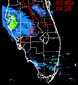
I agree with the westward drift. I'm also seeing a bulge in the NW Quadrant. Similar to an elongation in that direction.
Westward movement can be seen in the two images below.
Top image is at 0038Z and the second image is at 0341z, or about 30 minutes ago.
They are zoomed and centered on the 11 PM Center location from .


|
vineyardsaker
Weather Guru
Reged:
Posts: 151
Loc: New Smyrna Beach, FL
|
|
well, except that her boss simply won't pay her if she does not show up...
Looks like Fay is moving West. God willing, she will not have the time be load up more energy before leaving the coast.
--------------------
Charley(eyewall), Ivan, Jeanne, Dennis, Wilma, Irma, Ian (eyewall), Nicole, Helene
|
Storm Hunter
Veteran Storm Chaser

Reged:
Posts: 1370
Loc: Panama City Beach, Fl.
|
|
Fay appears to be moving... the 50 mile wide coc is already made it pass I-95 there in Daytona Beach on the west side... hard to tell if its a true west movement of a slight north/south of west movement... one thing is for sure... thats the largest center of circulation of a tropical low i have seen in a long time! I saw a great big blow-up of convection this evening over NW of tampa.. so there appears to be some warm water off that way... will see what happens tomorrow... as for Fay, i think she's leaving the Atlantic now, SLOWLY.. but she's feeling the high to the north and now looking for the weakness to the west/north/west of her.
Help show what its like at the surface there near Daytona Beach, Fl
--------------------
www.Stormhunter7.com ***see my flight into Hurricane Ike ***
Wx Data: KFLPANAM23 / CW8771
2012== 23/10/9/5 sys/strms/hurr/majh
Edited by Storm Hunter (Thu Aug 21 2008 12:36 AM)
|
Genesis
Weather Guru

Reged:
Posts: 125
|
|
It does appear, after watching this beast all night, that she's going to head west across the Peninsula this evening and be poised to emerge into the gulf sometime tomorrow evening or night.
This is not good from my point of view (NW Florida Panhandle) as if the storm goes straight west across and exits around Crystal River there's a very good chance it will have enough time to make mischief in the Gulf, and there's plenty of warm water there.
The only good news would something north of west that keeps it on land, more or less. But I don't see that in the behavior of the storm at this point in time.
Blech. I don't mind rain, even lots of it, but we do not need even a moderately strong 'Cane. A "lawn furniture rearranger", ok, but nothing stronger than that please!
The 1800Z HWRF plot is, uh, "disturbing".
http://my.sfwmd.gov/portal/page?_pageid=3194,21328260,3194_21169354:3194_21260388:3194_21260861&_dad=portal&_schema=PORTAL
|
danielw
Moderator
Reged:
Posts: 3527
Loc: Hattiesburg,MS (31.3N 89.3W)
|
|
Thanks Colleen.
Emergency Services- Fire Departments, Law Enforcement and Emergency Medical Service usually cease outside Operations at 45 mph wind speeds due to it being hazardous to the personnel.
Believe me. You don't want to be in a van type ambulance or larger, police cruiser or any Fire Apparatus in high winds. You have a tendancy to change lanes at a moments notice. And Mother Nature doesn't signal before changing lanes!!
All Danny said and fire hose streams are not effective in 50+ mph winds
Edited by Storm Cooper (Thu Aug 21 2008 12:23 AM)
|
vineyardsaker
Weather Guru
Reged:
Posts: 151
Loc: New Smyrna Beach, FL
|
|
ok. She will stay home tomorrow. thanks!
--------------------
Charley(eyewall), Ivan, Jeanne, Dennis, Wilma, Irma, Ian (eyewall), Nicole, Helene
|
danielw
Moderator
Reged:
Posts: 3527
Loc: Hattiesburg,MS (31.3N 89.3W)
|
|
Southern drift too?? Or expanding circulation?
Expanding Circulation.....JK
Edited by wxman007 (Thu Aug 21 2008 12:36 AM)
|
Colleen A.
Moderator
Reged:
Posts: 1432
Loc: Florida
|
|
After looking at some of model plots shown on local TV, it appears that they have shifted furher south..which would be exactly why we've seen the westward movement.
As far as your wife's boss not paying her for not showing up, PM me with what she would lose in money tomorrow if she put herself in danger, and I'll write you a check if it means keeping her safe and sound at home. Nobody's life has a price tag on it.
--------------------
You know you're a hurricane freak when you wake up in the morning and hit "REFRESH" on CFHC instead of the Snooze Button.
|


 Threaded


