Bev
Weather Guru

Reged:
Posts: 132
Loc: Port Charlotte, FL and Abaco, ...
|
|
Ed,
One excellent reason for posting an early state of emergency is to prevent price gouging for those purchasing supplies and fuel. If for no other reason, that's a positive result that saves significant amounts of money for people just beginning to prepare for the hurricane season. Without that preventive measure your gas might shoot up a couple $ per gallon as people try to profit from those preparing for a possible storm.
In addition, strength forecasting is one of the most difficult and error-prone areas of hurricane studies. It's difficult for the models and the mets. Better safe than sorry would the motto of the officials.
Although I can agree that any hint of a storm leads to near hysteria these days, when in past years we simply prepared our properties and got out of the way. (or some of us, right in the way  I attribute this change to the non-stop sensationalism that continues to this day. I attribute this change to the non-stop sensationalism that continues to this day.
In some ways it's good, it was a strong wake-up call for government agencies, local, state and national. In other ways it isn't so good as it seems to reduce the populace to a panicked mess. When Gustav was clearly headed for NO and not the west coast of FL, we still received 103 phone calls from elderly people who wanted their homes boarded up now, this instant, hurry! We only received 4 calls prior to , many barrier island folks didn't evacuate and we were ground zero until that last minute dash into Port Charlotte. The contrast is stark.
So as lessons are learned, the pendulum will swing from hyper-alertness back into complacency if we aren't hit again by a major storm any time soon. But yes, there is the "cry wolf" syndrome to consider. That will usher in the complacency. I imagine fewer will leave NO next time, as their experience with the Gustav evacuation was unpleasant and costly when they weren't allowed to return home for many days. Unfortunate but inevitable.
--------------------
Survived Charley at Cat 4 under a staircase. Won't do that again. I watch SW Florida and Abaco primarily.
|
metwannabe
Weather Hobbyist

Reged:
Posts: 92
Loc: NC
|
|
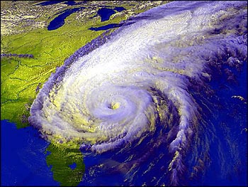
I do not want to write off Hanna just yet. Let's face it, in most years TC's would have dissapated by now in this hostile enviroment and yet she continues to be able to fire off convection. And this statement in the discusion catches my attention...
THE RECONNAISSANCE AIRCRAFT INVESTIGATING HANNA IS FINDING THE
CIRCULATION CENTER AT 850 MB DISPLACED TO THE NORTHWEST OF THE MEAN
CENTER OF ROTATION APPARENT IN THE LOW CLOUD LINES. THERE ARE ALSO
MULTIPLE SWIRLS...BUT IT DOES APPEAR THAT THE LOW-LEVEL CENTER HAS
JUMPED A LITTLE BIT TO THE WEST IN RESPONSE TO THE CONVECTIVE
ASYMMETRY.
Does this mean that the LLC is trying one last time to re-locate under the deep convection? And if so this would mean a slight westward shift in track and I would guess that if convection could maintain there is the warm waters of the gulf stream ahead, there could be a small window of possible strenghtening.
Also something not being mentioned much by or local mets is that the speed of Hanna would bring strong tropical storm force winds well inland and far up the coast line. Projections are for 60 mph winds around NC/VA border several hundred miles from landfall, some cat 2 or 3 hurricanes do not bring much more wind then this inland because they are not moving as fast. Just some thoughts and some things for NC/VA, and others in her path, to keep an eye on.
--------------------
Fran, Bertha, Dennis & Floyd (Tag Team)
|
TPuppy
Registered User
Reged:
Posts: 9
Loc:
|
|
State of Emergency
Hum, sounds bad, panicky, cry wolfish. Not so, the way this USA disaster system works is exactly like what Bev said, the sooner the better in the federal/state situation. A lot of ‘good things’ for residence happen once that ‘state of emergency’ declaration goes out. There is a long list of positives and not many negatives especially for the working class residents, so if you didn’t vote for your current governor this time around you may want to next time, because he must know the ropes. You may feel that it is alarmist, but in reality all kinds of safe guards and insurance benchmarks go into effect once a state of emergency is declared (and accepted). States cannot just declare without federal approval, so if a state of emergency has been declared and approved, you as a resident of the state can only benefit, as a business owner, you have to decide. But in most cases, if your county is declared a ‘state of emergency’, and things go wrong you will win the governmental struggle. If you have a bad situation, and your county is not in the ‘state of emergency’ envelope and something unexpected/bad happens : Re-elect, take an aspirin, change insurance companies, and bad mouth everyone else.
|
syfr
Verified CFHC User

Reged:
Posts: 19
Loc: Central NC
|
|
Some occasional heavy rain bands beginning here (SE of Raleigh ~30 miles). Going to be a soggy night for sure. Dead calm outside now, however.
|
|


 Threaded

 I attribute this change to the non-stop


