MikeC
Admin
Reged:
Posts: 4635
Loc: Orlando, FL
|
|
5PM Update Sep 25
Tropical Storm Kyle forms in the Atlantic North of the Caribbean moving Generally north. It appears to be no threat to the US, but may affect Canada later on. it is forecast to become a hurricane.
Original Update
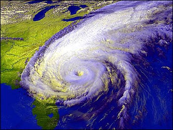
There is a new area of concern southeast of North Carolina that has formed from a stalled out cold front. It has the potential to at least cause some storm conditions (a decent lashing even) along the coast there, and may become a tropical or subtropical storm as it moves very slowly to the west over the next few days. This is being tracked as 94L.
The strong gradient associated with the system should cause a large area of brisk winds along the east coast.

Another system, 93L north of Hispaniola never formed before hitting the islands but has all the potential to become a depression or storm as early as today, it will then move more northward away from land.
We'll be watching both closely.
|
metwannabe
Weather Hobbyist

Reged:
Posts: 92
Loc: NC
|
|
Part of Ral NWC forecast discussion:
MEANWHILE SUGGEST THAT THE SYSTEM MAY GAIN SOME
SUB-TROPICAL CHARACTERISTICS AS IT DEPICTS A WARM CORE AT 850MB BY
THIS EVENING INTO THU. LOW LEVEL WIND FIELD HAS ALSO
STRENGTHENED WITH 850MB WINDS OF 60-70KTS PROJECTED FOR THE COASTAL
PLAIN BY DAYBREAK THU WITH 50-55KTS AT 925MB. MAY EVENTUALLY NEED A
WIND ADVISORY FOR THE EASTERN HALF OF CENTRAL NC FOR THURSDAY
MORNING.
IR sat. loop this morning almost has the look of something sub-tropical, although I doubt any warm core has started to develop. Either way interesting discussion and it would appear that here in Eastern NC will see just as much wind and rain if not more than we saw with Hannah.
--------------------
Fran, Bertha, Dennis & Floyd (Tag Team)
|
metwannabe
Weather Hobbyist

Reged:
Posts: 92
Loc: NC
|
|
Part of 10 am Ral NWC discussion...
...LIGHTNING ACTIVITY HAS GRAVITATED MORE TO THE CENTRAL CORE OF THE DEVELOPING
SYSTEM AND THOUGH THE SYSTEM IS CURRENTLY DEVELOPING ALONG A
STATIONARY FRONT THERE ARE INDICATIONS THAT THE SYSTEM COULD
BECOME WARM CORE AND DEVELOP INTO A SUBTROPICAL LOW PRESSURE
SYSTEM.
If this happens this could change the forecast drastically.
NHC has just issued STDS and I think that 'Kyle" has already formed, off of NC coast, not in the Carib., either sub-tropical or tropical. In fact IMHO I think will start issuing advisories before recon can get there.
--------------------
Fran, Bertha, Dennis & Floyd (Tag Team)
Edited by metwannabe (Wed Sep 24 2008 10:31 AM)
|
Raymond
Weather Guru
Reged:
Posts: 112
Loc: Germany
|
|
Yes, 94L could become Kyle and 93L later on Laura. Recon had been in the left overs of 93L and found a well defined flight level center well to the N of Hispaniola. Flight Level Winds max was 40 kt and surface level max 35 kt to the SE of the center. Convection has to start near the center and a distinct LLC has to form beneath it. Will take some time!
edit: I see a "eye-like feature" forming in the center of 94L!
Edited by Raymond (Wed Sep 24 2008 12:15 PM)
|
Marknole
Weather Watcher

Reged:
Posts: 47
Loc: Wacissa, FL
|
|
The visual presentation certainly looks like a hybrid ATTM. Very impressive convection currently wrapping from N-S on the north end of the circulation. Betcha starts advisories on Sub Tropical Storm Kyle soon.
Landfall/greatest effects over most of Carolinas' coasts seems reasonable, but limited models show JAX to N.E. Hope there's bettter guidance soon.
|
LoisCane
Veteran Storm Chaser

Reged:
Posts: 1237
Loc: South Florida
|
|
Looks a lot like other sub-tropicals that have clung to the coastline there.
Visually it looks very much like Karen in 2001 which was further to the East.
http://www.stormpulse.com/hurricane-karen-2001
It has very strong winds, is close to the coast and begs attention and the proper designation. I would think sub-tropical would fit and needs a name and advisories as it's not by any definition I can find a nor'easter. I'm sure someone could argue that. But... it's an interesting evolution either way and going to bring waves up and down the coast.
--------------------
http://hurricaneharbor.blogspot.com/
|
metwannabe
Weather Hobbyist

Reged:
Posts: 92
Loc: NC
|
|
NHC stated the following...
THE LOW IS PARTLY RESPONSIBLE FOR AN AREA OF WINDS TO HURRICANE FORCE WELL TO
THE NORTH AND NORTHWEST OF THE CENTER.
So why not start advisories? It would appear this meets sub-tropical requirements at least and IMHO people take these situations more serious when actual watches and warnings are posted, they do not tend to see the whole picture and seriousness of it when no warnings are issued.
--------------------
Fran, Bertha, Dennis & Floyd (Tag Team)
|
Bloodstar
Moderator

Reged:
Posts: 467
Loc: Tucson, AZ
|
|
Quote:
NHC stated the following...
THE LOW IS PARTLY RESPONSIBLE FOR AN AREA OF WINDS TO HURRICANE FORCE WELL TO
THE NORTH AND NORTHWEST OF THE CENTER.
So why not start advisories? It would appear this meets sub-tropical requirements at least and IMHO people take these situations more serious when actual watches and warnings are posted, they do not tend to see the whole picture and seriousness of it when no warnings are issued.
There are gale/storm warnings up for the coastal regions. But since the storm isn't considered a warm core storm by the and doesn't have tropical characteristics, then it isn't a tropical storm or hurricane. (though this appears to be changing, see below)
It looks like 93L has begun to fire some convection near it's nominal center. but there's a lot of shear over top which will probably prevent it from developing in the near term.
94L is a bit more complex, it seems to be warm core right now, at least according to phase analysis. However the low pressure still appears to be coupled to the frontal zone, which normally precludes a storm from being considered tropical. However, that is also changing and the frontal zone appears to be breaking down, which would give the system a much stronger case for being considered tropica/sub tropical.
--------------------
M. S. Earth and Atmospheric Sciences, Georgia Tech - May 2020
NOAA MADIS/HADS Programmer
U. Arizona PhD Student
|
cieldumort
Moderator

Reged:
Posts: 2484
Loc: Austin, Tx
|
|
Quote:
stated the following...
THE LOW IS PARTLY RESPONSIBLE FOR AN AREA OF WINDS TO HURRICANE FORCE WELL TO
THE NORTH AND NORTHWEST OF THE CENTER.
So why not start advisories?
As states, 94L looks to be essentially a well-developed and tightly-wound coastal "LOW" that is in the process of acquiring some tropical characteristics. The low is only "partly responsible" for the HF winds well to the north and northwest of the center. As of this morning, the area of interest was also still somewhat caught up in its parent fronts.
Recon might find enough reason to upgrade the system by 5PM, but is probably doing the right thing by not pulling the trigger just yet. This type of hybrid can sometimes fizzle out just as fast as it spun up.
|
LoisCane
Veteran Storm Chaser

Reged:
Posts: 1237
Loc: South Florida
|
|
My real question here is how has the forecasted track and intensity changed.
93 is looking red all of a sudden and 94 seems to be moving inland.. has the track changed if they both develop.
In Miami feels a lot like a coastal winter low or subtropical maybe. I know that's unscientific but for once I am not going to get hung up on a name. If this evolves into a subtropical it will .. it won't change what the weather conditions are and for NC and VA they are getting slammed either way with weather.
It's actually a very interesting set up to watch evolve. Tend to agree they can afford to wait a bit and see for sure as either way warnings and watches are up for high winds.
--------------------
http://hurricaneharbor.blogspot.com/
|
Hugh
Senior Storm Chaser
Reged:
Posts: 1060
Loc: Okaloosa County, Florida
|
|
Looking at the long-range Wilmington, NC, radar... I'd have to say 94L looks like it is closer to tropical than the reports. The strongest winds may be well removed but there is convection building near the LLC, and the radar presentation is improving. To me, if it looks like a hurricane, why not call it one, particularly when hurricane conditions are onshore?
--------------------
Hugh
Eloise (1975) - Elena and several other near misses (1985) - Erin & Opal (1995) - Ivan (2004)
|
vineyardsaker
Weather Guru

Reged:
Posts: 152
Loc: New Smyrna Beach, FL
|
|
Hi,
I just saw the following on the 8PM advisory on 94L:
Quote:
THIS STRUCTURE IS MORE CHARACTERISTIC OF AN EXTRA-TROPICAL WEATHER
SYSTEM. HOWEVER...THERE IS STILL THE POTENTIAL FOR THIS SYSTEM TO
BECOME A TROPICAL OR SUBTROPICAL CYCLONE TONIGHT OR THURSDAY
Could somebody please point me to a good (basic) definition of what a system needs to do to be considered , subtropical or tropical? Alternatively (or in addition) I would be interested in reading up on the kind of systems out there so maybe you could point me to a text available on the Internet which would provide an introduction to this topic for a layman?
Many thanks!
VS
--------------------
Charley(eyewall), Ivan, Jeanne, Dennis, Wilma, Irma, Ian (eyewall), Nicole, Helene, Milton
|
Random Chaos
Weather Analyst

Reged:
Posts: 1024
Loc: Maryland
|
|
The simplistic answer is:
Extratropical systems are asymmetric with winds well away from the center and the center generally exposed. They tend to look like a single spiral that rarely wraps more than about 1/2 to 3/4 around. A nor'easter is a good example of an system. These generally form over colder waters.
Tropical systems are symmetric with a tight inner wind maxima and clouds all the way up to the center (excluding an eye). Due to the dense , weak systems tend to look more like a single spiral, but more powerful systems develop a clear double spiral. These generally form over hot waters.
Subtropical systems are sort of half way between these too. They generally have the symmetric structure of a tropical system, but the winds are well away from the center and the center is sometimes exposed. These generally form over medium temperature waters.
Wikipedia info:
Extratropical: http://en.wikipedia.org/wiki/Extratropical_cyclone
Subtropical: http://en.wikipedia.org/wiki/Subtropical_cyclone
Tropical: http://en.wikipedia.org/wiki/Tropical_cyclone
I'm sure a met can give a much more detailed description, especially of exactly how to tell subtropical from the other two.
|
Raymond
Weather Guru
Reged:
Posts: 112
Loc: Germany
|
|
It´s time for at least TD 11 or even TS Kyle instead of 93 L. The system gets better defined around the core. There is also enough of a LLC at the western side of the convection and recon found recently SFMR surface winds up to 39 kt. The strom is sheared and also has to fight with dryer air from the west. I expect, that starts warnings on this one with the next update.
Another important thing about /tropical storm is, that the are cold in the core and the tropical are warm in the core. Warm waters below a system and undisturbed circumstnces help systems to transition to a tropical system. This needs time, usually 2-3 days, somtimes a bit faster. The conditions for 94 L to transition into a (sub)tropical system aren´t this good, because, it´s running out of time and has to fight with very dry air around the center. But as said in th warnings, it doesn´t matter much, because it´s a powerful storm in any case.
|
cieldumort
Moderator

Reged:
Posts: 2484
Loc: Austin, Tx
|
|
Have a vort that came in for 94L a little more supportive of naming it. 94L has developed a shallow warm core, and appears to be bringing in its radius of maximum sustained winds, while also exhibiting a little bit of banding-like structures around the center of circulation.
Highlights of center fix:
A. Time of Center Fix: 25th day of the month at 13:48:10Z
B. Center Fix Coordinates: 32°13'N 76°46'W (32.2167N 76.7667W) (View map)
D. Estimated (by SFMR or visually) Maximum Surface Wind: 54kts (~ 62.1mph)
E. Location of the Estimated Maximum Surface Wind: 31 nautical miles (36 statute miles) to the SSW (209°) of center fix
H. Minimum Sea Level Pressure: 994mb (29.35 inHg) - Extrapolated
I. Maximum Flight Level Temp & Pressure Altitude Outside Eye: 20°C (68°F) at a pressure alt. of 336m (1,102ft)
J. Maximum Flight Level Temp & Pressure Altitude Inside Eye: 23°C (73°F) at a pressure alt. of 334m (1,096ft)
Against naming 94L:
The Invest is still a bit wrapped up with its parent fronts.
The Invest continues to display a relatively structure on satellite.
|
metwannabe
Weather Hobbyist

Reged:
Posts: 92
Loc: NC
|
|
Long range Wilmington radar shows an almost large "eye" like feature present, that I don't think was there before. It also appears to be moving slowly n/nnw. It still has a small window of time to transition especially since it is moving or soon will be moving over the relatively warmer waters of the gulf stream.
Good news is it is running out of time.
--------------------
Fran, Bertha, Dennis & Floyd (Tag Team)
Edited by metwannabe (Thu Sep 25 2008 11:21 AM)
|
Ed in Va
Weather Master
Reged:
Posts: 489
Loc:
|
|
Looking more tropical...look at wrapping that is occuring...but may run out of ocean before it makes it:
http://www.intellicast.com/National/Radar/Current.aspx?animate=true
--------------------
Survived Carol and Edna '54 in Maine. Guess this kind of dates me!
|
Raymond
Weather Guru
Reged:
Posts: 112
Loc: Germany
|
|
Recon found 51 kt max. flight level winds at 500 feet height and estimated SFMR surface winds in the same range and there is a surface center. This is TS Kyle! It would be really a "political" decision by the to still refuse to give to 93L the TS-status with the next warnings.
94 L looks interesting. May be they`ll classify this one as subtropical before landfall. There is still the possibilty for it.
|
Thunderbird12
Meteorologist
Reged:
Posts: 644
Loc: Oklahoma
|
|
The 18Z SHIPS run for 93L is labeled as "Disturbance Kyle' with an initial intensity of 40 kts, so that would seem to indicate that it is about to finally be classified:
http://www.srh.noaa.gov/productview.php?pil=WBCCHGHUR
|
Rich B
British Meteorologist
Reged:
Posts: 498
Loc: Gloucestershire, England, UK
|
|
NRL and FNMOC both have 93L as Kyle... expect advisories to be issued around the usual 21z cycle.
--------------------
Rich B
SkyWarn UK
|


 Threaded


