MikeC
Admin
Reged:
Posts: 4544
Loc: Orlando, FL
|
|
9:00PM EDT 26 June 2010 Update
Recon aircraft in Alex has indicated that it may have regained Tropical Storm strength, and likely will be re-upgraded at 11PM.
8:00AM EDT 26 June 2010 Update
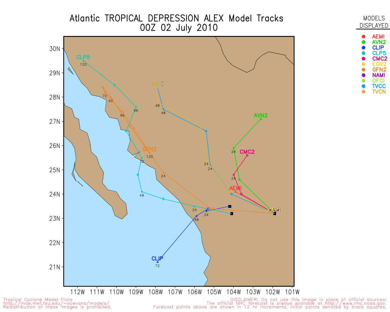
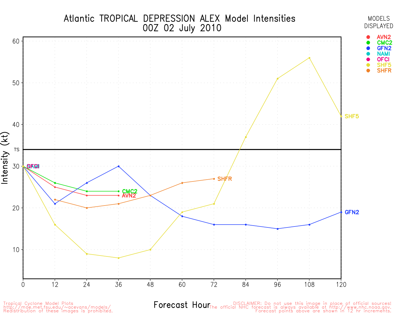
Alex has structurally held together quite well overnight, even being over land, but the max windspeed has lowered to a minimal Tropical Storm. There are two schools of thought, one is the more westwardly scenario (Which was talked about last night), which was based on the storm being weaker and the Euro, model trending, and one more northerly, which is based on the structure of the storm being stronger (GFS, Canadian).
Either way it will likely slow the forward motion over the storm quite a bit once back over water, and probably get enough of a chance to become a solid hurricane before landfall in Mexico. Those in the forecast cone will want to watch as the official forecast is forecasting a Category 2 hurricane, with a great deal of uncertainty either way. The potential for a major hurricane is there.
That said, the most likely scenario is that Alex makes a second landfall in Mexico. But confidence in that is low, and things could change. Those in the forecast cone need to watch Alex closely.

Key will be if it makes the left turn sooner or later, we probably won't know until Wednesday.
Belize Radar Recording (Flhurricane)
Belize City Webcam Recording(Flhurricane)
San Pedro Belize Webcam Recording(Flhurricane)
Weather at Belize City
Weather at Campeche, Mexico
Weather at Veracruz, Mexico
Weather at Poza Rica, Mexico
Weather at Tampico, Mexico
Flhurricane Facebook page
11:00PM EDT 26 June 2010 Update
Official forecast keeps Alex over the Bay of Campeche long enough to regain strength to hurricane force. We will watch trends into tomorrow.
9:30PM EDT 26 June 2010 Update
Alex appears to be inland now in Belize, and convection is running away from the center, judging by the way it's moving now it may never totally get in the Bay of Campeche at all and stay inland for an extended period of time. Whatever time it does get over the Bay, it seems it won't have much time to organize. This is good news as it likely will not develop as much as previously thought. In short it will likely stay a Tropical Storm, or less.
The wave northeast of the Caribbean (was 94L) is disorganize and likely will not develop.
4PM 26 June 2010 Update

Tropical Storm Alex is nearing landfall in Belize, and is strengthening as it does.
It is moving further west than the forecast track indicated, that means it may spend more time over the Yucatan before it gets in the Bay of Campeche. For Texas, it looks like you are not going to see any landfall, but Mexico, around Tampico, may.
7 AM 26 June 2010 Update
Tropical Depression one was upgraded to this year's first named storm, Alex. In response, Belize has put up Tropical Storm warnings. Alex has a little more time to strengthen (probably a good amount) before reaching the coast somewhere near the Belize/Mexico border.

Once over the Yucatan the system will likely weaken some, and may return to tropical depression status. It is likely to re-emerge Monday in the Gulf in the Bay of Campeche and generally head northwest. The most likely scenario after that is that it will bend back left and possibly landfall south of the Texas/Mexico border. However, there is some variation of that with the models, and those in south Texas will also want to watch the system closely. Those in the rest of the Gulf probably will not have to deal directly with Alex, but should monitor it in case things change.
Belize Radar Recording (Flhurricane)
Belize City Webcam Recording(Flhurricane)
San Pedro Belize Webcam Recording(Flhurricane)
Weather at Belize City
Weather at Veracruz, Mexico
Flhurricane Facebook page
Original Update
After careful recon, it appears 93L has formed well enough to become Tropical Depression #1. It is on the verge of becoming Tropical Storm Alex, and probably will before sometime tomorrow. Tomorrow night into Sunday early it will likely make landfall in the Yucatan
Then it is forecast to enter the Bay of Campeche Sunday night, and possibly reform into a Tropical Storm in the Western Gulf of Mexico.
Tropical Storm warnings are up in the Yucatan from Chetumal north to Cancun. They will likely see Tropical Storm Force winds and a lot of rain as it makes its way over the peninsula.

Those in the Western Gulf, from Louisiana, Texas and into Mexico will want to watch this system closely. Most likely scenario right now is that it stays further westward, but sits in the western central Gulf for a while--which complicates things. Landfall is a crapshoot, but south of the Texas/Mexico border as a Tropical Storm is the best guess. However, there is low confidence in that. This has more than enough time to change. Stronger windshear in the Gulf of Mexico and brisk upper level westerly winds could make for an interesting long range track (and weekend).
Where do you think it will go? If you want to discuss a guess or long range models, go to the lounge!
Those in the Gulf, especially Louisiana and Westward, need to watch this system over the next week.
94L northeast of the Caribbean has a 20% chance (and rising) to develop over the next 48 hours, but it is likely no threat to land at all.

More to come soon
Cancun Radar
|
doug
Weather Analyst
Reged:
Posts: 1006
Loc: parrish,fl
|
|
Not going to take long for upgrading now, as TD1 gets its act together quickly, continuing the organization that began this morning. Very evident center now with active blow ups of convection on both east and west sides. Movement looks to be NW as it crosses over 84W. Probably Alex already, but we will have to wait until next update.
--------------------
doug
|
MikeC
Admin
Reged:
Posts: 4544
Loc: Orlando, FL
|
|
TD#1 is looking like it'll hit Alex tonight, there is some very high cloud tops near the center of the system right now.
|
Hugh
Senior Storm Chaser
Reged:
Posts: 1060
Loc: Okaloosa County, Florida
|
|
Quote:
TD#1 is looking like it'll hit Alex tonight, there is some very high cloud tops near the center of the system right now.
You aren't joking. I've never seen cloud tops like this in a depression. I've rarely seem them in a tropical storm, in fact - they're normally not this high except in major hurricanes! And, it's HUGE.
--------------------
Hugh
Eloise (1975) - Elena and several other near misses (1985) - Erin & Opal (1995) - Ivan (2004)
|
WeatherNut
Weather Master
Reged:
Posts: 412
Loc: Atlanta, GA
|
|
This is going to ramp up quickly. There is an amazing amount of deep oceanic heat that is at record levels. I think there will be a better track forecast come morning once we see how quickly this develops.
--------------------
Born into Cleo (64)...been stuck on em ever since
Edited by WeatherNut (Fri Jun 25 2010 11:50 PM)
|
Storm Hunter
Veteran Storm Chaser

Reged:
Posts: 1370
Loc: Panama City Beach, Fl.
|
|
Quote:
This is going to ramp up quickly. There is an amazing amount of deep oceanic heat that is at record levels. I think there will be a better track forecast come morning once we see how quickly this develops.
I agree..the sats are showing a huge blow-up of convection over center... Things may get ugly tonight... Upper Level conditions are almost perfect now and with the covection firing near center... its prolly a TS now!
--------------------
www.Stormhunter7.com ***see my flight into Hurricane Ike ***
Wx Data: KFLPANAM23 / CW8771
2012== 23/10/9/5 sys/strms/hurr/majh
|
Hugh
Senior Storm Chaser
Reged:
Posts: 1060
Loc: Okaloosa County, Florida
|
|
Quote:
I agree..the sats are showing a huge blow-up of convection over center... Things may get ugly tonight... Upper Level conditions are almost perfect now and with the covection firing near center... its prolly a TS now!
NHC says it's still just barely below TS strength.
--------------------
Hugh
Eloise (1975) - Elena and several other near misses (1985) - Erin & Opal (1995) - Ivan (2004)
|
ftlaudbob
Storm Chaser

Reged:
Posts: 828
Loc: Valladolid,Mx
|
|
I have to say I'm also blown away by those cloud tops!It is wasting no time getting organized now.The ingredients are all there.The Yucatan is going to have a rough Sunday.Amazing to see what this system is doing now.
--------------------
Survived: 10 hurricanes in Rhode Island,Florida and the Yucatan of Mexico .
|
Hugh
Senior Storm Chaser
Reged:
Posts: 1060
Loc: Okaloosa County, Florida
|
|
Quote:
I have to say I'm also blown away by those cloud tops!It is wasting no time getting organized now.The ingredients are all there.The Yucatan is going to have a rough Sunday.Amazing to see what this system is doing now.
The outer bands have already hit the Yucatan - this thing is that big.
--------------------
Hugh
Eloise (1975) - Elena and several other near misses (1985) - Erin & Opal (1995) - Ivan (2004)
|
Storm Hunter
Veteran Storm Chaser
Reged:
Posts: 1370
Loc: Panama City Beach, Fl.
|
|
00z data is coming out... most models shifted to the left!
--------------------
www.Stormhunter7.com ***see my flight into Hurricane Ike ***
Wx Data: KFLPANAM23 / CW8771
2012== 23/10/9/5 sys/strms/hurr/majh
|
Hugh
Senior Storm Chaser
Reged:
Posts: 1060
Loc: Okaloosa County, Florida
|
|
Quote:
00z data is coming out... most models shifted to the left!
Good! From my standpoint, at least. I'm not sure one model run is a trend, though.
--------------------
Hugh
Eloise (1975) - Elena and several other near misses (1985) - Erin & Opal (1995) - Ivan (2004)
|
JordanBell
Registered User
Reged:
Posts: 4
|
|
Where are you getting this data?
--------------------
University of Missouri-2012
Atmospheric Science-GIS Minor
|
Hugh
Senior Storm Chaser
Reged:
Posts: 1060
Loc: Okaloosa County, Florida
|
|
Quote:
Where are you getting this data?
http://www.skeetobiteweather.com/picservice.asp?t=m&m=01
has most of the 00Z runs.
--------------------
Hugh
Eloise (1975) - Elena and several other near misses (1985) - Erin & Opal (1995) - Ivan (2004)
|
danielw
Moderator

Reged:
Posts: 3525
Loc: Hattiesburg,MS (31.3N 89.3W)
|
|
Models.
The only model I personally give any credit at this point is the . Fluid dynamics model.
It hasn't changed much. No further east than Appalachicola,FL and no further west than South Marsh Island, LA.
Use the loop at on the main page.
Have to wait and see what the 06 and 12Z models do with respect to consistancy.
The Yucatan Channel is roughly 600 miles from the mouth of the Mississippi River. Divide that by the storm movement speed and you get a rough estimate of landfall approximation.
600/ 15mph is 30 hours
600/ 10 mph is 60 hours
48 hours after the leading edge of the storm enters the GOM someone is going to be getting wet and windy. Exception at this point is Texas.
SATELLITE TROPICAL DISTURBANCE RAINFALL ESTIMATES
NWS TPC/NATIONAL HURRICANE CENTER MIAMI FL
0015 UTC SAT JUN 26 2010
SYSTEM NAME/IDENTIFIER...T.D. ONE (AL012010)
MAX RAINFALL
DATE/TIME LOCATION MOTION MEAN LAST
----------- ------------ ------ ------- -------
26/0015 UTC 16.6N 83.9W 295/07 14.3 IN 7.0 IN
LAST RAINFALL DISTRIBUTION...
DISTANCE LEFT OF CENTER RIGHT OF CENTER
------------- --------------- ---------------
0 TO 1 DEGREE 1.0 TO 3.5 IN 0.7 TO 2.2 IN
1 TO 2 DEGREE 1.1 TO 7.0 IN 0.1 TO 1.0 IN
2 TO 3 DEGREE 1.0 TO 3.2 IN 0.7 TO 3.3 IN
3 TO 4 DEGREE 0.0 TO 2.4 IN 0.0 TO 2.4 IN
|
mwillis
Weather Hobbyist

Reged:
Posts: 68
Loc: Cape canaveral
|
|
Its amazing the cloud presentation in this sat. image.
http://cimss.ssec.wisc.edu/tropic2/real-time/atlantic/images/xxirng8.GIF
|
Storm Hunter
Veteran Storm Chaser
Reged:
Posts: 1370
Loc: Panama City Beach, Fl.
|
|
00z moves wnw then west after landfall on Yucatan. Interesting to watch the setup with the model and the first 24hrs on the run.
--------------------
www.Stormhunter7.com ***see my flight into Hurricane Ike ***
Wx Data: KFLPANAM23 / CW8771
2012== 23/10/9/5 sys/strms/hurr/majh
Edited by Storm Hunter (Sat Jun 26 2010 02:17 AM)
|
Hugh
Senior Storm Chaser
Reged:
Posts: 1060
Loc: Okaloosa County, Florida
|
|
New advisory package is out. No significant changes. Forecast shifted slightly west at day 4/5, but not much else changed.
--------------------
Hugh
Eloise (1975) - Elena and several other near misses (1985) - Erin & Opal (1995) - Ivan (2004)
|
Storm Hunter
Veteran Storm Chaser
Reged:
Posts: 1370
Loc: Panama City Beach, Fl.
|
|
11pm Adv. is out., and no change in strength... still a TD.. but they did shift the track slightly left and at the end a turn toward the MX/TX border.
--------------------
www.Stormhunter7.com ***see my flight into Hurricane Ike ***
Wx Data: KFLPANAM23 / CW8771
2012== 23/10/9/5 sys/strms/hurr/majh
|
LakeToho
Unregistered
|
|
I found a really nice site that give you a lot of information in one area. It maybe useful to many.
http://www.stormpulse.com/fullscreen/current
|
WeatherNut
Weather Master
Reged:
Posts: 412
Loc: Atlanta, GA
|
|
Looks like latest recon has found 50mph winds SW of the center
--------------------
Born into Cleo (64)...been stuck on em ever since
|


 Threaded


