Ed Dunham
Former Meteorologist & CFHC Forum Moderator (Ed Passed Away on May 14, 2017)
Reged:
Posts: 2565
Loc: Melbourne, FL
|
|
8 AM EDT 20 August 2010
The first sign of activity for next week is the East Atlantic system, designated 95L this morning.
This system is likely to develop slowly at first, but is fairly likely to develop. But not until early next week (Monday or Tuesday).
Once it does develop, odds highly favor it becoming a hurricane that goes out to sea well before the islands of the Caribbean.
6 PM EDT 19 August 2010
Continued slowness throughout the Atlantic basin, with two areas with a slight development chance.
The first area, in the West Caribbean is running out of time to develop and likely will just impact central America with rainfall, and another area in the far west Atlantic that may develop next week if it persists, but even if it does odds are it would stay out to sea.
There may be other activity next week to watch, but nothing this week.
7:45 AM EDT 18 August 2010
The area in the Caribbean likely won't develop and will just be a rainmaker, and the rest of the basin is fairly quiet, and likely to remain so most of this week.
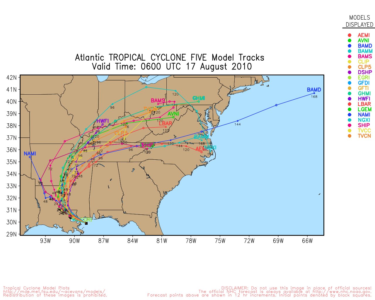
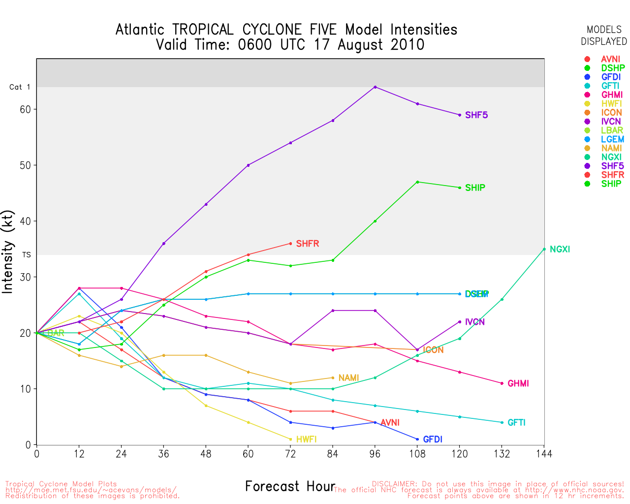
7:45 AM EDT 17 August 2010
The remnants of Tropical Depression five have moved back onshore eliminating the chances for development it had, This leaves the Atlantic without any pending areas to track. Which for this time in August is pretty rare. One wave in the east Atlantic has fizzled and likely will not develop, another may later.
There is also an area in the East Caribbean that may be worth watching. Convection has increased as the wave interacts with an upper level low in the central Caribbean.
In short, not much happening in the next few days. Late this week into next week may get busy, however.
6:45 AM EDT 16 August 2010
The system formerly known as tropical depression 5 has a chance to reform as early as this afternoon, but will likely only bring more rainfall to the area. Most of the rain is currently offshore and south of the center of the storm, which right now is just south of Panama City Beach in the Florida panhandle.

The system is forecast to loop over the gulf and make landfall again somewhere near the Louisiana/Mississippi border likely Thursday.
In the meantime the system has a chance to become a Tropical Storm and cause minor surge and plenty of rainfall. For most areas of the gulf it will be a non-event.
Beyond that, it is quiet in the Atlantic, and the next hint of development may be in the Eastern Atlantic late this week.
7 AM 15 August 2010
It's mid August, and with a mostly quiet Atlantic there is a system that has hung around and is likely to move back over water, the former Tropical Depression #5 area.
The system is currently near Montgomery, Alabama, the area is expected to drift southward over the Florida Panhandle and re-emerge into the Gulf of Mexico overnight tonight, there it has a brief opportunity to regain strength and become a tropical depression or storm again. Conditions are actually more favorable once it gets back into the gulf than when TD#5 originally formed.
Looping tropical systems are notoriously hard to predict, but the best guess is another landfall early Wednesday near Louisiana as a tropical storm or depression.
Overall though, Odds are that it just will continue to bring rain, as the biggest issue with it developing is likely to be not enough time over water.
Original Update
The remnants of former TD5 are now over eastern Louisiana, southern Mississippi and southern Alabama. position estimate at 13/18Z was 31.4N 88.2W. Some models poke it back out over the northern Gulf, but as weak as this system has become, I don’t think that it would be of much consequence since some models still maintain a mid-level low over the Florida panhandle and Alabama. Area is worth watching since heavy rain potential still exists in Alabama. Added: At 14/00Z the center position estimate was 32.2N 87.0W - the system has been moving to the northeast on Friday - away from the coast.
A broad area of lower pressure north of Panama and east of Nicaragua has some cyclonic curvature. The area is centered near 13.5N 79W and has been stationary. Convection remains on the outer limits of the system. The Atlantic side of Panama has no windshear, but the Pacific side is under moderate easterly shear. There is a slight chance for some slow development in this area.
A non-tropical system east of the Carolinas is developed into a stronger system by many of the longer range models and slowly transitioned into a more tropical system as it heads off to the northeast. Probability for tropical cyclone development is still low, but it has some potential and worth keeping an eye on.
A well developed tropical wave will exit the west African coast at about 18N in a couple of days – this wave has remained intact and large and looked well developed when it was at 17E quite a few days ago. Another SAL outbreak started yesterday and now extends south to the Cape Verde Islands, so like others before it, this new wave will have dry air ahead of it to contend with. But this one seems to have enough structure to have a better chance for survival and could become a tropical system in about a week.
Sat24 West Africa Loop
Just some areas to watch - nothing is expected to develop in the next few days.
ED
Edited by Ed Dunham (Sat Aug 21 2010 10:17 AM)
|
MichaelA
Weather Analyst

Reged:
Posts: 951
Loc: Pinellas Park, FL
|
|
The wave approaching the African coast does look strong. We'll see if it survives after emerging into the Atlantic, though. Looks like there are two more waves traversing the African continent behind it, but they don't appear to be quite as strong. The area in the Caribbean looks a little less organized now than it did earlier today, but certainly bears watching while the area on the Pacific side has succumbed to the shear over it today. The Caribbean area does have a lot of moisture to work with and fairly good UL divergence. That's a heck of a trough off the East coast with lots of shear, so betting nothing develops there. The trough moving across the central US should help kick the remains of TD5 to the NE and E in the next few days.
--------------------
Michael
PWS
|
berrywr
Weather Analyst

Reged:
Posts: 387
Loc: Opelika, AL
|
|
All kidding aside; time to take TD5 Remnants more serious....Marine Weather Discussion and models have the system returning to the GOM next week and are now hinting at the possibility of redevelopment with a track once again to the west across the northern portion of the GOM. Models are all over the place in regards to how strong the remnants are likely to become; being much, much stronger at 96 hours and the having the system remaining weak.
Stu Ostro made a pretty darn good case for the remnants of TD5 in fact being a depression (on his Facebook page) as it stalled just SE of LA and S of MS with radar having convective bands almost completely wrapping around the low level center Thursday morning.
Depending on how far the system re-emerges into the GOM will go a long way determining if the models verify and to what degree the system can be classified a depression or storm next week.
--------------------
Sincerely,
Bill Berry
"Survived Trigonometry and Calculus I"
Edited by berrywr (Fri Aug 13 2010 05:32 PM)
|
WesnWylie
Weather Guru
Reged:
Posts: 155
Loc:
|
|
The remnants of TD 5 are flaring up a lot over the inland this afternoon. The center appears to be along the south-central border of Mississippi and Alabama. The latest model runs are not showing this system getting as strong in the gulf as they were with the previous run or two. I guess we'll see what it does during the early to mid part of next week. BTW, Joe Bastardi has a good commentary regarding the remnants of TD 5 on Accuweather.com.
--------------------
2011 Season Forecast: 16/09/04
2011 Systems: 10/01/01
|
MikeC
Admin
Reged:
Posts: 4627
Loc: Orlando, FL
|
|
It's going to be a quiet weekend, but later in the week it looks like there may be more to track, and the pattern is starting to change, late August into September will likely be pretty busy.
|
berrywr
Weather Analyst
Reged:
Posts: 387
Loc: Opelika, AL
|
|
To borrow a few lines from MythBusters - Everybody take a look at the 14/00Z global models package and ask yourself - Busted or Plausible? I think the is a bit overdone, but the which has been very, very good this season along with every model I looked at put this low back in GOM moving it south starting tomorrow. This morning it looks very good on satellite imagery despite appearing a bit elongated. It even has some banding.
--------------------
Sincerely,
Bill Berry
"Survived Trigonometry and Calculus I"
|
MichaelA
Weather Analyst
Reged:
Posts: 951
Loc: Pinellas Park, FL
|
|
It certainly looks like the remains of TD5 are doing a loop over Alabama this morning moving generally toward the SE. Persistent little bugger, isn't it? The does appear to be a bit over-aggressive.
--------------------
Michael
PWS
|
Ed Dunham
Former Meteorologist & CFHC Forum Moderator (Ed Passed Away on May 14, 2017)
Reged:
Posts: 2565
Loc: Melbourne, FL
|
|
The latest SAL outbreak that started a couple of days ago is turning out to be rather significant and it could shut off the eastern Atlantic for awhile.
UW SSEC SAL Loop
Here is a link where you can watch the easterly waves as they approach the west coast of Africa:
Sat24 West African Satellite Loop
Cheers,
ED
|
MichaelA
Weather Analyst
Reged:
Posts: 951
Loc: Pinellas Park, FL
|
|
I've been watching that SAL outbreak. It's also visible on the vis sat pics as well. That's a fairly strong SAL air mass and I'm wondering how those African waves will fare once they enter the Atlantic.
--------------------
Michael
PWS
|
berrywr
Weather Analyst
Reged:
Posts: 387
Loc: Opelika, AL
|
|
NHC has a bullseye over Alabama and 20% chances. Models continue to suggest re-development is plausible.
--------------------
Sincerely,
Bill Berry
"Survived Trigonometry and Calculus I"
|
danielw
Moderator

Reged:
Posts: 3527
Loc: Hattiesburg,MS (31.3N 89.3W)
|
|
Since it's a once in a year occasion that a TD forms over the Southeast US. I'm going to post the graphic. Yes, a 20% chance of tropical development from an overland system.
And while I'm posting things that are strange. did run the basic tropical models on the remnants of TD5. It generated one 6 or 12 hour period with 15 kt winds and the models dissipated XTD 5.
I don't think it's going to go away that easy. Kind of in a cutoff low situation. Canadian model takes it well offshore and down to 1005 mb. Which probably isn't much lower than it is right now.

|
danielw
Moderator
Reged:
Posts: 3527
Loc: Hattiesburg,MS (31.3N 89.3W)
|
|
Very good presentation/ explanation of what X TD 5 is doing and is forecast to do. Might belong in the forecast lounge, but system is somewhat current.
MARINE WEATHER DISCUSSION NWS TPC/NATIONAL HURRICANE CENTER MIAMI FL 350 AM EDT SUN AUG 15 2010
(excerpt~danielw)
...THE RIDGE WILL WEAKEN NEXT 30 HOURS AS GLOBAL MODELS CONTINUE TO
SHIFT LOW PRES INTO THE NE GULF COASTS MON MORNING THEN DRIFT IT
W AND ACROSS SE LOUISIANA THROUGH TUE EVENING BEFORE TURNING NW
AND COMPLETELY INLAND ACROSS SW LA TUE NIGHT-WED MORNING.
CONTINUES TO BE VERY AGGRESSIVE WITH THIS LOW AND DEEPENS IT MON
NIGHT INTO TUE TO TROPICAL STORM STRENGTH. CANADIAN IS SOMEWHAT
SIMILAR AND A BIT FARTHER S IN TRAJECTORY WHILE REMAINDER OF
MODELS HAVE SIMILAR MOTION BUT DO NOT SHOW NEAR THE
STRENGTHENING. THIS LOW IS PERSISTING UNDERNEATH AN UPPER LEVEL
HIGH AND WILL MOVE SW THEN W WITHIN THE INNER PERIPHERY OF THIS
UPPER ANTICYCLONE AS IT MOVES OVER WATER. WE ARE MONITORING THIS
SYSTEM DURING ITS EVOLUTION NEXT 48 HOURS...BUT STILL REMAIN ON
THE CONSERVATIVE SIDE ATTM UNTIL SOME DEFINITIVE IMPROVED
STRUCTURE IS EVIDENT IN STLT OR RADAR. WILL CONTINUE TO GO WITH
15-20 KT WINDS ON S AND SE QUADS OF THIS LOW AS IT MOVES ACROSS
THE N CENTRAL GULF MON THROUGH TUE...
http://weather.cod.edu/kamala/TPC/latest.agxx40.KNHC.html
|
Hugh
Senior Storm Chaser
Reged:
Posts: 1060
Loc: Okaloosa County, Florida
|
|
Just when you thought it was safe to go back into the water....
Looking at the satellite loops, the convection is growing around the remnants of TD 5 at an alarming rate very near to the coast. The LLC is still over land, but it's headed for the northeast Gulf, and while there's no convection near the LLC right now, the actual spin looks intact. It would not surprise me for it to be bumped up to code orange at 2pm. Heck, it looks better right now - with the LLC over land! - than it did for the last 12-24 hours when it was over the eastern Gulf before the recon couldn't locate a LLC. I almost got caught in the rain yesterday from this system - it was just light sprinkles when I was out and about but for a brief period of time there was a heavy downpour.
Regardless of whether the decides to re-pull the trigger and call this thing TD 5 again, it's going to be a wet week along the Gulf coast.
--------------------
Hugh
Eloise (1975) - Elena and several other near misses (1985) - Erin & Opal (1995) - Ivan (2004)
|
WesnWylie
Weather Guru
Reged:
Posts: 155
Loc:
|
|
I have a feeling we will have a tropical depression to track by sometime tomorrow. I think this is the type of system that can catch a lot of people off guard by "spinning up" quickly. I'll definitely be watching it since if its track were to shift just a little west my area could be affected by it. 
--------------------
2011 Season Forecast: 16/09/04
2011 Systems: 10/01/01
|
Hugh
Senior Storm Chaser
Reged:
Posts: 1060
Loc: Okaloosa County, Florida
|
|
Quote:
I have a feeling we will have a tropical depression to track by sometime tomorrow. I think this is the type of system that can catch a lot of people off guard by "spinning up" quickly. I'll definitely be watching it since if its track were to shift just a little west my area could be affected by it.
It's not supposed to get south enough to make it to Texas, I don't think.
Looking at the ball of convection south of Mobile, if the LLC were to reform (which wouldn't be out of the ordinary I don't think), we could have a depression or even a storm VERY quickly. Right now the LLC is over land, so the won't pull the trigger even if there are reports of 40mph winds offshore, I don't think... but... you never know.
--------------------
Hugh
Eloise (1975) - Elena and several other near misses (1985) - Erin & Opal (1995) - Ivan (2004)
|
WesnWylie
Weather Guru
Reged:
Posts: 155
Loc:
|
|
When the LLC gets into the GOM which will it be labeled prior to being a tropical depression again?
1.As the old wave it was before (94L)
2.A new wave (95L)
3.The Remnants of TD 5, so 05L
Just curious.
Edited by WesnWylie (Sun Aug 15 2010 11:50 AM)
|
orlandoweather
Registered User
Reged:
Posts: 3
Loc:
|
|
Should be TD5 should be a strong tropical storm not so sure about a hurricane though
|
Hugh
Senior Storm Chaser
Reged:
Posts: 1060
Loc: Okaloosa County, Florida
|
|
Quote:
When the LLC gets into the GOM which will it be labeled prior to being a tropical depression again?
1.As the old wave it was before (94L)
2.A new wave (95L)
3.The Remnants of TD 5, so 05L
Just curious.
My gut feeling, based upon satellite presentation, is that it will immediately be re-classifed as TD Five - possibly even before the LLC gets over the GOM. It's hard to pinpoint, but I think the LLC is just southwest of the AL/GA/FL tri-border, and moving south. Convection near that locaton is almost non-existent, but it's very impressive southwest of there in the Gulf. I've seen systems - including this one - with less convection call a tropical depression before.
There is no sound reasoning to call it 95L, since it is the exact same system that became TD 5.
--------------------
Hugh
Eloise (1975) - Elena and several other near misses (1985) - Erin & Opal (1995) - Ivan (2004)
|
mwillis
Weather Hobbyist

Reged:
Posts: 68
Loc: Cape canaveral
|
|
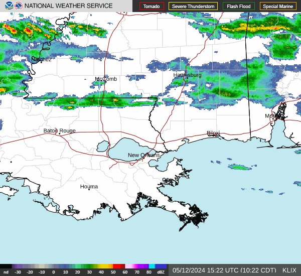
Does anyonne know if this looks like a new convestion center forming off gulf coast? Not sure if its just thunderstorm related or low pressure related. look at the right side of the radar, do u see the"circle" of thunderstorms?
http://radar.weather.gov/radar.php?rid=LIX&product=NCR&overlay=11101111&loop=yes
|
Hugh
Senior Storm Chaser
Reged:
Posts: 1060
Loc: Okaloosa County, Florida
|
|
Quote:
Does anyonne know if this looks like a new convestion center forming off gulf coast? Not sure if its just thunderstorm related or low pressure related. look at the right side of the radar, do u see the"circle" of thunderstorms?
http://radar.weather.gov/radar.php?rid=LIX&product=NCR&overlay=11101111&loop=yes
Too far west to be a LLC forming - yet. It does show a very high cloudtop on the AVN loop at that spot, though.
--------------------
Hugh
Eloise (1975) - Elena and several other near misses (1985) - Erin & Opal (1995) - Ivan (2004)
|


 Threaded


