Bloodstar
Moderator

Reged:
Posts: 462
Loc: Tucson, AZ
|
|
Quote:
In response to your analysis - the latest run reflects on Fiona stalling and looping off the FL Coast at 6 and 7 days out. This seems to be a direct result of Earl "cleaning" things out and leaving little in his path to steer Fiona. Thoughts?
Personally, I can't imagine Fiona stalling and looping right now, While steering currents may weaken in a short term, I think the model in question has kinda missed with the latest run. If other models start picking the idea of a stall or loop, then it could be worth looking into.
Now mind you, we are looking at a steering environment made more complicated by a major hurricane. So the models may have more trouble handling a vastly stronger storm relatively close to a weaker one. The models may handle it fine, but it's worth keeping in mind for each run.
--------------------
M. S. Earth and Atmospheric Sciences, Georgia Tech - May 2020
Brookhaven National Laboratory
U. Arizona PhD Student
|
danielw
Moderator

Reged:
Posts: 3525
Loc: Hattiesburg,MS (31.3N 89.3W)
|
|
Fiona's BAMD is an outlier, off topic, But it appears to be following the CIMSS steering current maps. To some degree.
http://moe.met.fsu.edu/~acevans/models/al082010.png
Steering Currents for > 1000mb
Edited by danielw (Tue Aug 31 2010 07:04 PM)
|
MikeC
Admin
Reged:
Posts: 4544
Loc: Orlando, FL
|
|
Earl's eyewall replacement cycle may be nearly over, and the result may be a smaller (and more turbulent) eye , which may give it a shot to strengthen more. Dry air to the northwest may starve Earl and weaken it some on the other hand.
|
MichaelA
Weather Analyst

Reged:
Posts: 944
Loc: Pinellas Park, FL
|
|
Although, it does appear that there may be some dry air advection beginning on the W and SW side and some hint of increasing shear as well, looking at both the vis loop and WV loop.
--------------------
Michael
PWS
|
Old Sailor
Storm Tracker

Reged:
Posts: 293
Loc: Florida
|
|
The latest run on Earl with 1200Z shows Boston as the bull eyes, time will tell but feel eastern New England is under the gun...
|
bobbutts
Weather Hobbyist

Reged:
Posts: 71
Loc: New Hampshire
|
|
Not quite Boston..

|
k___g
Weather Guru

Reged:
Posts: 110
Loc: Leesburg, FL
|
|
Based on the current visuals, Earl has made his turn poleward!!! He will send some high tides and stormy weather into the U. S. East coast but that should be it. However, areas north of Maine need to watch out.
|
danielw
Moderator
Reged:
Posts: 3525
Loc: Hattiesburg,MS (31.3N 89.3W)
|
|
Something has flattened Earl's Western and Southern sides. A Square Hurricane???

|
ftlaudbob
Storm Chaser

Reged:
Posts: 829
Loc: Valladolid,Mx
|
|
Quote:
The latest run on Earl with 1200Z shows Boston as the bull eyes, time will tell but feel eastern New England is under the gun...
Looks to me like the bulls eye is Rhode Island.
--------------------
Survived: 10 hurricanes in Rhode Island,Florida and the Yucatan of Mexico .
|
MichaelA
Weather Analyst
Reged:
Posts: 944
Loc: Pinellas Park, FL
|
|
It looks like another wobble, similar to yesterday's to me. It's still pretty much on a mostly WNW path with maybe a slight tendency more toward NW.
--------------------
Michael
PWS
|
Rad
Weather Guru

Reged:
Posts: 173
Loc: St. Pete Fl. {27.8N 82.7W}
|
|
Quote:
Quote:
The latest run on Earl with 1200Z shows Boston as the bull eyes, time will tell but feel eastern New England is under the gun...
Looks to me like the bulls eye is Rhode Island.
Dont worry , It will change by then
--------------------
RIDE 2 LIVE 2 RIDE
|
danielw
Moderator
Reged:
Posts: 3525
Loc: Hattiesburg,MS (31.3N 89.3W)
|
|
DRY Air Entrainment. Excellent photo. Thanks NOAA.
If this dry air keeps going Earl might just Poof.

Edited by danielw (Tue Aug 31 2010 08:45 PM)
|
bobbutts
Weather Hobbyist
Reged:
Posts: 71
Loc: New Hampshire
|
|
Quote:
Quote:
The latest run on Earl with 1200Z shows Boston as the bull eyes, time will tell but feel eastern New England is under the gun...
Looks to me like the bulls eye is Rhode Island.
No.. the center is well east of both Boston and Rhode island (on the 12Z euro)
|
danielw
Moderator
Reged:
Posts: 3525
Loc: Hattiesburg,MS (31.3N 89.3W)
|
|
I hate to ask you guys to stop the dialogue about the models. But 5 days is a long period in the tropics.
Models are very inconsistant at 5 days... with 360 mile/ 6 degrees of leeway left or right of track.
If you would like to continue the model discussion you can discuss at will in the Forecast Lounge.
Current model departure at 120 hour/ 5 day ranges from the EGRR model at 325 sm to the BAMD at 779 sm.
http://www.tropicalatlantic.com/models/d...verage#position
http://www.tropicalatlantic.com/models/data.cgi?basin=al&year=2010&storm=07
THIS PRODUCT IS UNDER DEVELOPMENT. FEEL FREE TO TEST IT,
BUT DO NOT TRUST THE OUTPUT UNTIL MORE TESTING IS DONE.
Edited by danielw (Tue Aug 31 2010 09:12 PM)
|
MichaelA
Weather Analyst
Reged:
Posts: 944
Loc: Pinellas Park, FL
|
|
I noticed that a couple of hours ago. 
Earl is still trying to ignore that entrainment and appears to be trying to suck what life Fiona has out of her too.
--------------------
Michael
PWS
|
danielw
Moderator
Reged:
Posts: 3525
Loc: Hattiesburg,MS (31.3N 89.3W)
|
|
Earl appears to be fighting the dry air entrainment by placing a wall on the western side of the center.
Shaped like a croissant the western side is steadily gaining height while the NE Quadrant is eroded to a much lower height.
Notice the thin cirrus fingers on the western side. Dry air has abated somewhat, or dropped to lower levels, as they cover more of the western semicircle than a few hours ago.

|
MichaelA
Weather Analyst
Reged:
Posts: 944
Loc: Pinellas Park, FL
|
|
Earl is regaining symmetry again, so the dry air was insufficient to have had a lasting effect it seems. It looks like that NWesterly turn is beginning to take shape too.
--------------------
Michael
PWS
|
Random Chaos
Weather Analyst

Reged:
Posts: 1024
Loc: Maryland
|
|
I think in many ways the water vapor image shows your point even better, Daniel. You can really see the dry air spun into the storm just north of the COC.
Regional:
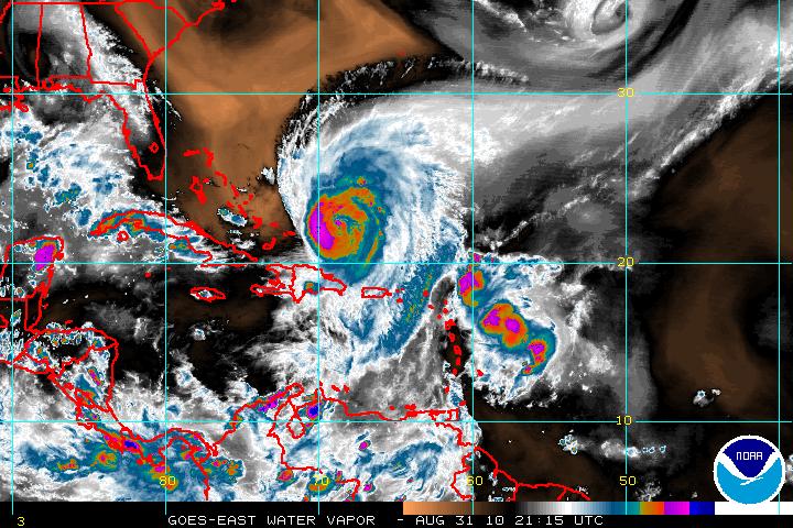
Floater:

Also, no beauty pictures today. TERRA and AQUA's overpasses were all edge-on views of the storm today.
|
civil2183
Registered User
Reged:
Posts: 3
Loc: Tampa, FL
|
|
Just a passive observer of the site. It seems to only be briefly mentioned, but it seems clear to me that Earl has been drawing Fiona into itself over the past day. I know in the past, this has happened (I believe it was the 95 season I saw it happen, might of been Karen), though rarely, that the stronger storm swallows the weaker storm. I believe it also effects the stronger storm during this process. Can anyone give some clarity to what the effects on Earl will be during this process? How long this might take and do the models have this predicted in already?
Thanks
|
mcgowanmc
Weather Hobbyist
Reged:
Posts: 96
Loc: NW ARKANSAS
|
|
Yes. This is exactly what is happening.
http://www.ssd.noaa.gov/goes/east/watl/flash-wv.html
This will push Earl farther to the West. Maybe South Carolina Cat 5.
Connie/Diane 1955 came close until this pm.
Tomorrow Dawn, Earl will be a different hurricane.
|


 Threaded


