MikeC
Admin
Reged:
Posts: 4560
Loc: Orlando, FL
|
|
8AM EDT Update - Sunday, 5 September 2010
Earl is no longer, Ex-Gaston and an area in the Bay of Campeche (90L) Both have a chance to form today or tomorrow.
The area east of Gaston fell apart and is no longer being tracked as 99L.
90L has a chance to make tropical storm status before moving inland in Northern Mexico or extreme southern Texas, but it will not have the time to strengthen.
b]4PM EDT Update - Saturday, 4 September 2010
Earl is inland over Nova Scotia in Canada. The remnants of Gaston are set to reform likely later tonight or tomorrow, and another disturbance in the Southwest Gulf of Mexico has a shot at forming into a Tropical Storm tomorrow before Landfall in Northeast Mexico or southern Texas (not currently an invest). And Fiona dissipated. The other system east of Ex-Gaston (99L) will have to be watched later in the week as well.
Gaston's Remnants are likely to edge along the Northern Leewards and just north and continue westward, so it appears the Bahamas and perhaps Florida will want to watch what happens with what was Gaston later this week. Those in the Leewards will want to watch even sooner because if it redevelops they will likely be in the cone.
11PM EDT Update - Friday, 3 September 2010
Earl is now a strong Tropical Storm moving about 80 miles southeast of Cape Cod and heading toward eastern Nova Scotia on Saturday. Sustained winds are now at 60 knots and Earl is moving to the northeast at 22 knots. Updated Warnings and Watches are listed in the Meteorological Blog.
New England Hourly Weather Reports
Fiona has degenerated into a remnant low that is expected to dissipate over the weekend.
The former Gaston is once again developing deep convection and will likely become a tropical cyclone again over the weekend as the system moves to the west northwest.
Invest 99L is slowly organizing off the west coast of Africa as it moves to the northwest at about 8 knots. Still not certain as to whether 99L will be able to survive the dry air environment that it is moving into.
ED
7:00 AM EDT Update Friday, 3 September 2010
t

Earl is Northeast of Cape Hatteras this morning, and most of the wind has stayed offshore, with the extreme eastern outer banks seeing strong tropical storm force winds.
Hurricane Earl is expected to near Cape Code in the Early Morning hours tomorrow.
8:30 PM EDT Update Thursday, 2 September 2010
Earl is nearing the North Carolina Coastline, but is moving more northerly now and thankfully, it appears the center of the system will not make landfall, although winds will be very high. Earl has weakened to a category 2 storm
Those in the Cape Cod area will like also see a very close call.
Gaston has been downgraded to an open wave, but may regenerate later and will be watched.
Flhurricane Recording of Radar (and more) of Earl US Approach
Keep up with where Mark Sudduth (Hurricanetrack.com) is as he drives around the Outer Banks of North Carolina
Hatteras Lighthouse Cam flhurricane recording
Kill Devil Hills Pier Video Stream
Flhurricane recording of HurricaneTrack's Tower Cam
Media:
WECT 6TV - Wilmington, NC
WITN 7 - Eastern North Carolina TV (NBC)
WCTI 12 - Eastern North Carolina (ABC)
WNCT TV 9 - Eastern North Carolina (CBS)
Wavy 10 (NBC) - Hampton Roads/VA Beach, VA TV
WTKR 3 (CBS) - Hampton Roads/VA Beach, VA
WVEC 13 (ABC) - Hampton Roads/VA Beach, VA
Papers:
Outer Banks Sentinel
Wilmington Star News Online
Hampton Roads Pilot
Keep up with where Mark Sudduth (Hurricanetrack.com) is as he drives around the Outer Banks of North Carolina
Flhurricane Recording of French Antilles radar for FIona Approach
6:15 AM EDT Update Thursday, 2 September 2010
Hurricane Earl has probably peaked earlier this morning, but remains a strong category 4 storm. It is forecast to come very close (40-60 miles) of the outer banks, still as a major hurricane. Any deviation to the west would bring the worst of it onshore. Those in the warning areas should pay attention to local media and officials about any evacuations or recommendations.
Today should be spent in final preparations and leaving as conditions will begin to deteriorate in North Carolina in the late afternoon or evening. Closest approach to North Carolina would likely bit in pre-dawn hours tomorrow.
After passing near/over North Carolina, Earl is forecast to stay offshore the mid Atlantic, but Nantucket has a chance to get part of the western eyewall. Because of this hurricane watches are in effect now (in addition to the other warnings/watches) from north of the NC/VA Border to Cape Henlopen in Delaware. And now also from westport to Plymouth, MA (along with cape code/Martha's Vineyard and Nantucket) Those in Martha's Vineyard and Nantucket would be wise to begin preparations now.

Wind fields tend to expand when the storms get further north, so there is a good chance a large area in the northeast may experience some strong winds.
Beyond that, Extreme Northeast Maine may be a landfall, and Canada will either way, and it is likely Earl still will be a hurricane when it does.
Fiona is on the out to sea path, but has a chance to come close to Bermuda (on the west side). Therefore Bermuda is under a Tropical Storm watch for FIona.
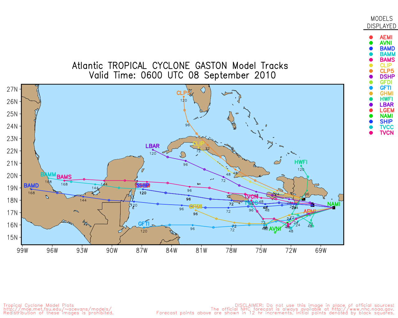
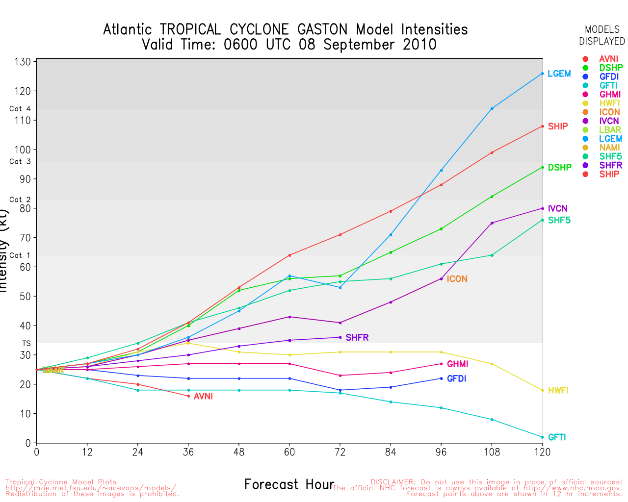
Gaston is remaining weak this morning, but expected to continue to track west. Gaston is moving much slower than the other storms, and may not reach closer to the Leeward islands until mid-late next week. Odds favor Gaston not going out to sea, so it will be one to watch then.
Beyond Gaston is another wave (not being tracked as a proper invest yet) that has a 10% chance to develop over the next 48 hours, but more of one later on.
8:30PM EDT Update Wednesday 1 September 2010
Recon airfract has found a lower pressure in Earl of 932mb, which indicates Earl is continuing to strengthen.
Those still on the outer banks are highly recommended not to take the risk of a major storm approaching your area and leave.
Odds favor the center of it staying offshore, but the large size will still pound hurricane force winds along parts of the coast.


6:00PM EDT Update Wednesday 1 September 2010
Earl has continued to strengthen with maximum sustained winds reaching 135MPH and Tropical Depression 9 has become Gaston, the 7th tropical storm of the season.

Meanwhile Fiona is struggling and may not survive to the weekend. Since Gaston remains far from land, all eyes remain on Earl with Tropical Storm and Hurricane Watches and Warnings stretching from North Carolina to the New Hampshire border.
There is another wave just off Africa (east of Gaston) that we'll need to watch next week also.
10:30AM EDT Update Wednesday 1 September 2010
The wave in the Central Atlantic looks to be upgraded to Tropical Depression 9 at 11AM.
Hurricane Earl was re-upgraded to Category 4 status, and Earl is forecast to remain a major as it goes right next to the outer banks of north Carolina. With a storm of this size, I would not stay on the outer banks if you are there.
8AM EDT Update Wednesday 1 September 2010
Fiona has strengthened a bit since influence from Earl has been decreasing, it is now up to 60MPH Winds.
Chances for Development of the wave in the central Atlantic (98L) have gone up to 80%. This system would be named Gaston, and odds favor the more westerly track.
See original update for Earl information:
Original Update
Hurricane Earl has weakened a bit overnight due to dry air and small amounts of shear, but it is still a major hurricane. Earl is forecast to be at it's closest point to the outer banks of North Carolina Thursday night into Friday morning.
The majority of models keep Earl just offshore, but close enough to cause problems. A few, such as the take it inland into North Carolina. Those in the warning area, In short, prepare for the worst and hope for the best, and you should be looking at local advisories, officials, and Media.
The Hurricane Watches for North Carolina may be upgraded to Hurricane Warnings later today.
Those north of there along the coast will want to watch Earl closely for any changes or additional watches and warnings. Especially in Eastern Massachusetts/Cape Cod.
Those in Canada in the forecast track zone should begin to prepare as well.

Tropical Storm FIona is being caught up in the northerly flow from Earl, and currently is just offshore North and East of the Leeward islands, the official forecast takes it northward and eventually stalls near Bermuda, but there is some uncertainty with the forecast so the next day or two is critical for the eventual path of FIona. Fiona will likely stay weak, unless effects from Earl drop off quicker than expected or a center relocation southward happens. Fiona is still very much worth watching.
Tropical Storm warnings and Watches are up for the Leewards for Fiona.
Out east of both is the wave 98L, which now has a 50/50 shot at development over the next few days. Odds favor this going generally westward, so those in the Leewards, again, will have to watch it closely.
Another system just over the west side off Africa also has a chance to develop into next week, and odds favor it moving more westward (Ie not out to sea) as well.
|
MikeC
Admin
Reged:
Posts: 4560
Loc: Orlando, FL
|
|
Fiona is looking very interesting right now, (not strong, just interesting). It's not quite caught up in Earl, and a lot of the convection is south of the center. And I'm very curious to see if the current Fiona forecast track sticks or not.
Those in the outer banks will want to keep watch on Earl.
|
MikeC
Admin
Reged:
Posts: 4560
Loc: Orlando, FL
|
|
Added several links to the main page in prep for Earl/Fiona:
Media:
WECT 6TV - Wilmington, NC
WITN 7 - Eastern North Carolina TV (NBC)
WCTI 12 - Eastern North Carolina (ABC)
WNCT TV 9 - Eastern North Carolina (CBS)
Wavy 10 (NBC) - Hampton Roads/VA Beach, VA TV
WTKR 3 (CBS) - Hampton Roads/VA Beach, VA
WVEC 13 (ABC) - Hampton Roads/VA Beach, VA
Papers:
Outer Banks Sentinel
Wilmington Star News Online
Hampton Roads Pilot
Flhurricane Recording of French Antilles radar for FIona Approach
Also Mark Sudduth Tracker Sudduth Tracker/Hurricanetrack
|
Random Chaos
Weather Analyst

Reged:
Posts: 1024
Loc: Maryland
|
|
Just a few notes this morning.
Earl:
1. Earl is currently down to a Category 3 as of the 5am update.
2. Earl's pressure is currently 943mb per Dropsonde at 11:32 GMT (7:32 EDT), up slightly but not significantly.
3. Earl's IR appearance looks to be improving steadily.
Fiona:
1. Fiona is down to 998mb per Vortex Recon and Dropsonde at 11:30 GMT (7:30 EDT). This is a 8mb drop in an hour and a quarter from the 10:15 GMT Dropsonde and Vortex Recon, but only a 3mb drop over the past 5 hours based on other Dropsondes and Vortex Recons.
2. The distance between Earl and Fiona is increasing, which should allow Fiona to stop experiencing such strong negative effects due to Earl, which may allow it to strengthen a little.
Invest 98L:
1. Edit: As of 8am update, Invest 98L now has an 80% chance of development by . Original Update: Invest 98L has been raised to a 50% development change by , up from a 10% chance last night.
Edited by Random Chaos (Wed Sep 01 2010 08:06 AM)
|
hogrunr
Weather Guru

Reged:
Posts: 153
Loc: Spring, TX
|
|
Now have TD 09 according to site.
|
WeatherNut
Weather Master
Reged:
Posts: 412
Loc: Atlanta, GA
|
|
I saw that as well. It has good rotation and has generated some convection near the center. It is also about 3 degrees south of where the other storms have been moving so west so upwelling wont be as significant of a problem. This should also follow a more southerly track.
--------------------
Born into Cleo (64)...been stuck on em ever since
|
MikeC
Admin
Reged:
Posts: 4560
Loc: Orlando, FL
|
|
We're dealing with some site traffic issues today and are tweaking settings apologizing in advance if the site briefly goes down occasionally.
Donations haven't quite reached the needed level for the new hardware, yet. We may have to turn off a few features if traffic keeps climbing.
|
doug
Weather Analyst
Reged:
Posts: 1006
Loc: parrish,fl
|
|
Fiona: looks to be in dire straits...being ripped apart by the shear from Earl's outflow. Circulation exposed, and by all appearances will become merged with the huge feeder to its west. I cannot see this surviving another 24 hours.
--------------------
doug
|
CFHC

Reged:
Posts: 149
Loc: East Central Florida
|
|
We apologize for the outages of flhurricane.com. We had to drive to the data center location of the server to do a power reset first one in over 5 years.. Current Hardware has been working hard now for 8 years. If you would like to donate for hardware upgrades please click here, or visit the Site Donations on the left menu bar. Thank You for you continued support. -CFHC
Edited by MikeC (Wed Sep 01 2010 05:16 PM)
|
MikeC
Admin
Reged:
Posts: 4560
Loc: Orlando, FL
|
|
We did some large config changes this afternoon in hopes of clearing up the issues faced earlier today. Our hardware is getting a bit old (we run a lot of background cane info services), so hopefully the optimizations will pull us through for the next few weeks at least.
Thanks for those that donated, and them and everyone else for coming to the site!
|
Random Chaos
Weather Analyst
Reged:
Posts: 1024
Loc: Maryland
|
|
A beautiful hurricane!

Higher Resolution Versions: http://rapidfire.sci.gsfc.nasa.gov/gallery/?2010244-0901/Earl.A2010244.1801.2km.jpg
|
typhoon_tip
Meteorologist
Reged:
Posts: 576
|
|
Well ... we have our selves a real dicey situation up in eastern Long Island, RI and eastern/SE MA.
I have been watching the water vapor imagery over the northwest Atlantic Basin periodically during the day and the ridge prominence in the vicinity is impressive as an anticyclonic lobe is currently pressing ESE toward the lower Maritimes. Enough so to make me want to question the NAM's recent east trend per the 12Z and now 18Z guidance cycles.
The key is going to be the exact morphology of the of the current closing deep layer vortex over the Great Lakes, and what effect that has on tipping the flow more south to north in orientation in the steering levels along and off the East Coast. The past 48 hours of modeling has unilaterally showed gradually more latitudinal amplitude (not just wind maxes) with that large synoptic evolution, which I believe is pretty strongly related to why we have inched Earl west over time.
That said, Earl seems really on a NNW trajectory to me as of the last 3 hours. We'll see how this holds ... but the last 1 hour "wobble motion" is also pretty clearly due N. The more north component this system gets earlier on, the better off SE New England will be. So this may tentatively be good news farther up the Coast.
NC and VA residence should definitely keep up with on-going preparations relative to advisory status
Edited by typhoon_tip (Wed Sep 01 2010 06:53 PM)
|
Random Chaos
Weather Analyst
Reged:
Posts: 1024
Loc: Maryland
|
|
Those of us on the Chesapeake Bay also need to watch.
Western shore of the bay (NWS Sterling):
Quote:
DEPENDING ON HOW CLOSE EARL IS TO THE REGION AND HOW FAST THE STORM IS MOVING WILL DETERMINE TIDAL ANOMALIES. AT THIS POINT...WATER LEVELS ARE EXPECTED TO RANGE FROM 1 TO 3 FEET ABOVE NORMAL DURING TIMES OF HIGH TIDE THURSDAY AND THURSDAY NIGHT. THIS WILL BRING THE POSSIBILITY OF MINOR TO MODERATE TIDAL FLOODING THURSDAY AND THURSDAY NIGHT.
With the Bay's orientation and the storm positioning us in the NW and W quadrants primarily, we can expect significant wave effects. Those with NE or N exposure are most at risk between combined waves and tidal effects.
Most models keep the system far enough offshore that we don't expect major effects, but a few models have trended west over the past couple of runs, so everyone needs to continue watching this along the mid-Atlantic.
|
RevUp
Weather Guru
Reged:
Posts: 181
Loc:
|
|
Earl has made a decidedly more northward turn in the last few hours, now moving toward 330 at 18 mph. Good news for the US east coast.
--------------------
"Let tomorrow worry about itself. Each day has enough trouble of its own."
|
Random Chaos
Weather Analyst
Reged:
Posts: 1024
Loc: Maryland
|
|
Miss Piggy is in the storm.
Eyewall dropsonde:
Surface winds of 113 kts, 951mb surface pressure in the eyewall.
Low altitude winds at 944mb were at 142 kts!
Eye vortex recon:
Surface pressure down to 932mb!
Edited by Random Chaos (Wed Sep 01 2010 08:25 PM)
|
ftlaudbob
Storm Chaser

Reged:
Posts: 829
Loc: Valladolid,Mx
|
|
Quote:
Miss Piggy is in the storm.
Eyewall dropsonde:
Surface winds of 113 kts, 951mb surface pressure in the eyewall.
Low altitude winds at 944mb were at 142 kts!
Eye vortex recon:
Surface pressure down to 932mb!
This is getting more serious by the min.Earl is getting stronger.
--------------------
Survived: 10 hurricanes in Rhode Island,Florida and the Yucatan of Mexico .
|
MichaelA
Weather Analyst

Reged:
Posts: 945
Loc: Pinellas Park, FL
|
|
And approaching the Gulf Stream - deep, warm water with lots of heat content. This is not good for the Outer Banks.
--------------------
Michael
PWS
|
danielw
Moderator

Reged:
Posts: 3525
Loc: Hattiesburg,MS (31.3N 89.3W)
|
|
We had what appeared to be a rather fast moving trough or dry front move through Mississippi this afternoon. I'm not real sure what that might do. ( I think I know, and it's not very good for folks on the Eastern Seaboard.)
I don't recall seeing mention of any fronts passing through here until Thursday or Friday.
Will the shortwave push or pull Earl?
932mb gives a maximum possible windspeed of 143 mph.
The following Model Discussion is a bit old. But worth reading, I think.
MODEL DIAGNOSTIC DISCUSSION
NWS HYDROMETEOROLOGICAL PREDICTION CENTER CAMP SPRINGS MD
221 PM EDT WED SEP 01 2010
VALID SEP 01/1200 UTC THRU SEP 05/0000 UTC
...HURRICANE EARL...
THE 09Z/SREF MEAN...ALONG WITH THE 12Z NAM...12Z/GFS...AND THE
12Z/CMC HAVE TRENDED WEST WITH TRACK OF EARL DURING DAYS 2 AND 3.
THE 12Z/UKMET INDICATES AN EASTWARD TREND COMPARED TO ITS 00Z
RUN...WHILE THE 12Z/ECMWF MAINTAINS A CONSISTENT TRACK. THE SREF
AND INDICATE A SLOWER TREND...WHILE THE HAS TRENDED FASTER
THAN ITS PREVIOUS RUNS. THE MODEL CONSENSUS TAKES THE CENTER
CLOSE TO THE 40N/70W BENCHMARK. THE 12Z/GFS TRACK IS NOTABLY WEST
OF THE MODEL CONSENSUS. SEE THE LATEST ADVISORY FROM THE NATIONAL
HURRICANE CENTER.
Edited by danielw (Wed Sep 01 2010 08:58 PM)
|
Random Chaos
Weather Analyst
Reged:
Posts: 1024
Loc: Maryland
|
|
A 2nd dropsonde, this one in the outgoing eyewall, read 927mb surface pressure / 104kt surface winds. That is 5mb lower than the vortex recon reported the eye being only a few moments earlier. Weird.
Earl is shedding outer convective bands. Generally you only see this when a storm is becoming annular. Everyone needs to watch this storm very closely. Microwave shows no sign of an to weaken the storm anytime soon.
The loss of outer convective bands on the north and west sides can be easily seen on IR: http://www.ssd.noaa.gov/goes/east/nwatl/flash-rb.html
Also, note the close up AVN IR loop: The eye is almost completely cloud free with a very cold eyewall now - http://www.ssd.noaa.gov/goes/flt/t2/flash-avn.html - and also on the water vapor loop - http://www.ssd.noaa.gov/goes/flt/t2/flash-wv.html
Edited by Random Chaos (Wed Sep 01 2010 09:13 PM)
|
MichaelA
Weather Analyst
Reged:
Posts: 945
Loc: Pinellas Park, FL
|
|
Does this WV loop shed any light on that?
US WV Loop
--------------------
Michael
PWS
|


 Threaded


