MikeC
Admin
Reged:
Posts: 4667
Loc: Orlando, FL
|
|
7PM EDT Update
Hurricane Irene has much better satellite presentation this evening than it did earlier today, and now has a "pinhole" eye. The official forecast track has moved slightly west and now makes landfall near Atlantic Beach, NC. Saturday Afternoon. After this it exits near Virginia Beach, skims Delaware, and then makes another landfall near Wildwood, NJ. Sunday Afternoon, then over New York CIty, NY and up through CT. MA, NH, and ME. The rough side of the storm is forecast to be in Boston.
The wind field of Irene is very large and strong Tropical Storm force winds will be felt on either side of the system quite a ways out, and hurricane force closer to the center. Large amount of storm surge along the coast as the size of Irene will move large amounts of water.
Those in areas affected need to prepare and listen to local media and official.

Hurricane Warnings up for:
Little River Inlet, SC (AT the SC/NC Border) to The NC/VA Border
Hurricane Watches north of there into Sandy Brook, NJ
Tropical Storm Warnings south to Edisto Beach
Tropical Storm Watches up for the Chesapeake Bay and Tidal Potomac
5PM EDT Update
Hurricane Warnings up for North Carolina. Hurricane Watches up to Sandy Hook, NJ. Tropical Storm Warning for most of South Carolina.
Those in the Watch and warnings areas need to prepare for dangerous conditions and possibly days without power in some areas. Please listen to local media and officials for information about your local area.
Original Update
Hurricane Watches are now up from Surf City, NC along the outer banks to the North Carolina/Virginia border. This means hurricane conditions are expected in the area by 48 hours.
Those in the outer banks should consider evacuating today if you haven't already, this system will be over or much closer to the coast and larger than Hurricane Earl that passed by to the east last year. Earl is expected to be a major hurricane at Landfall. Please heed all evacuation orders, Irene's models have been trending back into North Carolina rather than away since noon of yesterday. Listen to local media and officials in the watch/warning areas.
Conditions will likely slowly deteriorate tomorrow night into Saturday, with landfall probably midday Saturday in the Outer Banks.
Tropical Storm watches are up south of Surf City into Edisto Beach in South Carlina (Between Hilton Head and Charleston, SC).
For Florida, some extreme outer rainbands from Irene will begin approaching South Florida later this morning, and may spread north later in the day. This can be seen on south Florida Radar

Once Irene has passed the Outer Banks, Irene is expected to stay just offshore near the Delmarva peninsula and into western Long Island , NY, Sunday afternoon still as a hurricane. Guidance trends suggest this is fairly likely latest trends have it possible for the track to be slightly west of the current one as well, which would cause the core of Irene to move along the Delmarva, into New Jersey and ride the coast into New Hampshire and Maine, a large portion of New England north of New York and Rhode Island may be affected by a weaker (but still destructive) Irene.
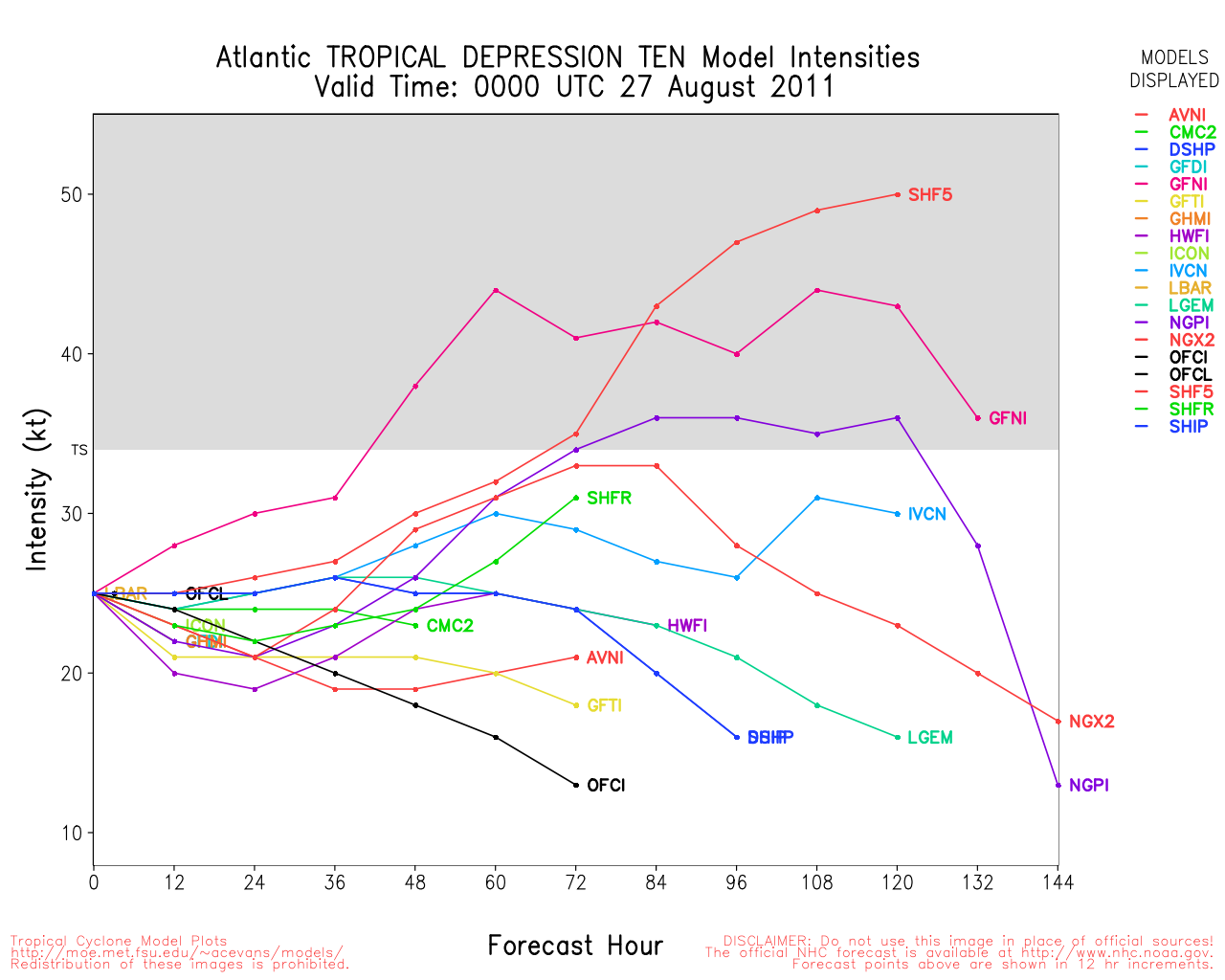
Tropical Depression 10 has formed in the Far Eastern Atlantic, is expected to remain far out to sea without affecting any land areas. It is likely it will become a Tropical Storm.
Irene went through an eyewall replacement process last night that has temporarily weakened the storm wind wise, when the eye reemerges it is likely to be larger than previously seen and regain its strength to be a major hurricane as it crosses or clips the Outer Banks of North Carolina. The wind gradient is flatter right now,so the drop in windspeed is valid. The pressure is the lowest it has ever been in Irene, at 950mb, so when it recovers from the eyewall replacement cycle winds will likely pick up again drastically. After 2 days though vertical shear should halt any more strengthening of Irene.
What's happening weather wise or people wise regarding Irene in your area? Let us know here.
See the Forecast Lounge for more speculation on Irene.
Event Links
Flhurricane Disaster and preparatory information thread.
Landfall Area Media:
WECT 6TV - Wilmington, NC
WITN 7 - Eastern North Carolina TV (NBC)
WCTI 12 - Eastern North Carolina (ABC)
WNCT TV 9 - Eastern North Carolina (CBS)
Wavy 10 (NBC) - Hampton Roads/VA Beach, VA TV
WTKR 3 (CBS) - Hampton Roads/VA Beach, VA
WVEC 13 (ABC) - Hampton Roads/VA Beach, VA
Papers:
Outer Banks Sentinel
Wilmington Star News Online
Hampton Roads Pilot
Power Outage Maps
Eastern Carolinas Power outage Map
Virginia Power outage Map
Maryland/DC Power Outage Map
Keep up with where Mark Sudduth (Hurricanetrack.com) is as he drives around the Outer Banks of North Carolina
Irene Storm Surge Probabilities
We are now recording the Rocky Bay webcam at Abaco Island in the Bahamas -- note these images are large.
Hope Town Fire rescue on Abaco Island, storm information
Updated Map of Mark Sudduth from HurricaneTrack.com, with video and radar for Irene approach See HurricaneTrack.com for more information.
RGB satellite recording of Irene.
Long Term Long Range US Radar of Irene
Map plot of Irene overlaid on Hurricane Floyd (1999) track
Long term Central Atlantic wide area Water Vapor Satellite for Hurricane Season Peak flhurricane)
Long term West Atlantic wide area Water Vapor Satellite for Hurricane Season Peak flhurricane)
|
Random Chaos
Weather Analyst

Reged:
Posts: 1024
Loc: Maryland
|
|
We also have Tropical Depression 10 in the mid Atlantic. It's heading north and should do nothing but spin fish.
Recon
6:30am update: Vortex recon about an hour ago found the eye to be 30nm in diameter, but the max winds out at a band around 45nm diameter. Looks like the mentioned at 11pm is wrapping up and it's now trying to clear out the old core. Central pressure has been steady around 950mb for the last several hours, with an HDOB message within the last few minutes still at that level.
6:50am update: HDOB messages from AF300 found the strongest winds around 35 miles from the center at 112kt. This supports surface winds up to 115mph, matching the 5am advisory. Miss Piggy will be sampling that same region in the next half hour or so.
7:00am update:
Product: Air Force Vortex Message (URNT12 KNHC)
Transmitted: 25th day of the month at 10:49Z
Aircraft: Air Force Aircraft (Last 3 digits of the tail number are 300)
Storm Number & Year: 09L in 2011
Storm Name: Irene (flight in the North Atlantic basin)
Mission Number: 19
Observation Number: 11
A. Time of Center Fix: 25th day of the month at 10:24:50Z
B. Center Fix Coordinates: 25°08'N 76°18'W (25.1333N 76.3W)
B. Center Fix Location: 65 miles (105 km) to the E (86°) from Nassau, Bahamas.
C. Minimum Height at Standard Level: 2,687m (8,816ft) at 700mb
D. Estimated (by SFMR or visually) Maximum Surface Wind: 55kts (~ 63.3mph)
E. Location of the Estimated Maximum Surface Wind: 27 nautical miles (31 statute miles) to the SSW (210°) of center fix
F. Maximum Flight Level Wind Inbound: From 290° at 58kts (From the WNW at ~ 66.7mph)
G. Location of Maximum Flight Level Wind Inbound: 25 nautical miles (29 statute miles) to the SSW (208°) of center fix
H. Minimum Sea Level Pressure: 952mb (28.11 inHg)
I. Maximum Flight Level Temp & Pressure Altitude Outside Eye: 12°C (54°F) at a pressure alt. of 3,045m (9,990ft)
J. Maximum Flight Level Temp & Pressure Altitude Inside Eye: 17°C (63°F) at a pressure alt. of 3,051m (10,010ft)
K. Dewpoint Temp (collected at same location as temp inside eye): 11°C (52°F)
K. Sea Surface Temp (collected at same location as temp inside eye): Not Available
L. Eye Character: Open in the southwest
M. Eye Shape & Diameter: Circular with a diameter of 30 nautical miles (35 statute miles)
N. Fix Determined By: Penetration, Radar, Wind, Pressure and Temperature
N. Fix Level: 700mb
O. Navigation Fix Accuracy: 0.02 nautical miles
O. Meteorological Accuracy: 2 nautical miles
Remarks Section - Remarks That Were Decoded...
Maximum Wind Outbound: 112kts (~ 128.9mph) in the northeast quadrant at 10:32:00Z
Maximum Flight Level Wind: 112kts (~ 128.9mph) in the northeast quadrant at 10:32:00Z
Remarks Section - Additional Remarks...
EYE WALL WELL DEFINED 020-090
Every IR satellite update the storm is looking healthier right now. Eye is starting to become visible on the last image and is clearing out nicely. It is open south (rotated some from the southwest noted in the vortext recon), but I would expect that to fill quickly. The storm looks very healthy and very large. There is nothing to stop it strengthening over the next few hours.
Track
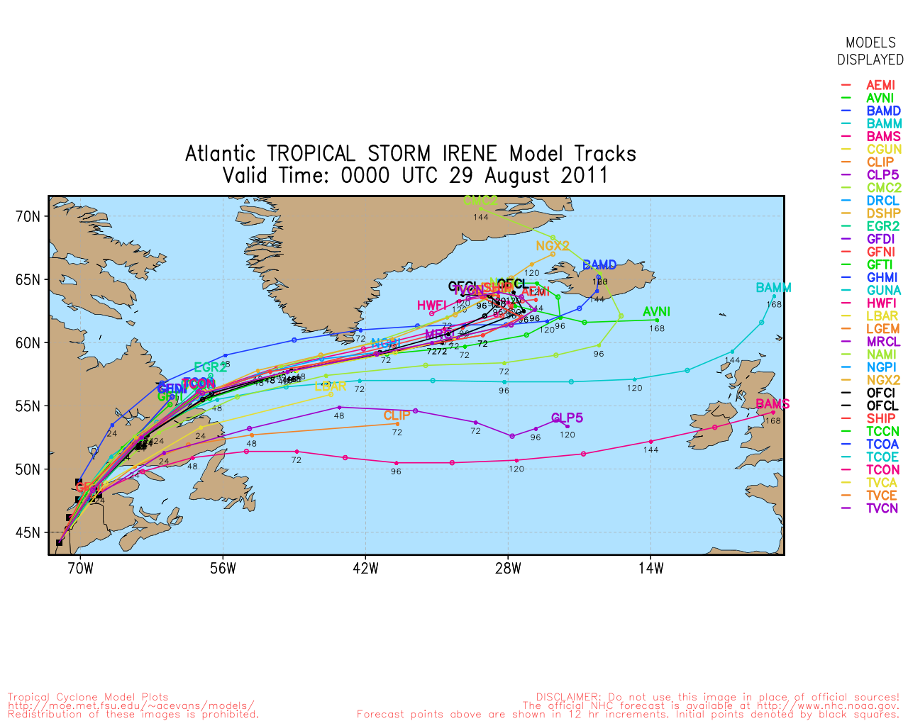
Majority of the models have shifted far enough west to make the hit in North Carolina rather than Long Island in around 72 hours. There is some divergence following landfall, with some models having the storm re-exit land in North Carolina, while other models drag the storm inland after landfall. This is still far enough off that models will continue to shift, and the storm could move east or west of it's current official track. Given it's track nearly parallel to land, a small shift can result in a huge difference in where landfall occurs, anywhere from South Carolina through Canada.
Land effects on hurricanes tend to drag them to the right when impacting directly due to the spin of the storm and the land-based drag due to the terrain. However, if a storm grazes land on it's left side, as this storm will do, I am not sure if this will cause a faster or slower landfall. The models do not take into account this effect.
The models showing the more inland track are the and kin, including the GFDT, GFDI, and GFTI. The GFNI and GFDN also make an inland jog, but not so much. Given the accuracy of the and kin models with past storms, I would not ignore the potential of these tracks. See: http://www.ral.ucar.edu/guidance/realtim..._track_late.png
Edited by Random Chaos (Thu Aug 25 2011 07:25 AM)
|
danielw
Moderator

Reged:
Posts: 3527
Loc: Hattiesburg,MS (31.3N 89.3W)
|
|
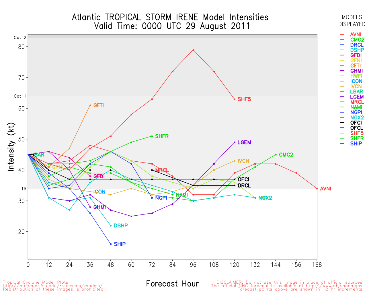
With a 950mb storm and an completing I would think that the winds speeds would increase to 125 mph or better in the next 6 hours.
950mb gives a Max Possible windspeed of 125mph.
Storms can and do exceed the Mpw.
But it's a rare event.
|
MikeC
Admin
Reged:
Posts: 4667
Loc: Orlando, FL
|
|
Based on recon, Irene is starting to move north north northwest this morning and picking up a little speed, it'll be racing along by the time it gets to New England.
Right now it's basically over Eleuthera Island in the Bahamas.
|
Random Chaos
Weather Analyst
Reged:
Posts: 1024
Loc: Maryland
|
|
Concentric eyewalls again.
Product: NOAA Vortex Message (URNT12 KWBC)
Transmitted: 25th day of the month at 11:31Z
Aircraft: Lockheed WP-3D Orion (Reg. Num. N43RF)
Storm Number & Year: 09L in 2011
Storm Name: Irene (flight in the North Atlantic basin)
Mission Number: 20
Observation Number: 13
A. Time of Center Fix: 25th day of the month at 11:11Z
B. Center Fix Coordinates: 25°18'N 76°30'W (25.3N 76.5W)
B. Center Fix Location: 55 miles (88 km) to the ENE (73°) from Nassau, Bahamas.
C. Minimum Height at Standard Level: Not Available
D. Estimated (by SFMR or visually) Maximum Surface Wind: 85kts (~ 97.8mph)
E. Location of the Estimated Maximum Surface Wind: 32 nautical miles (37 statute miles) to the E (95°) of center fix
F. Maximum Flight Level Wind Inbound: From 172° at 116kts (From the S at ~ 133.5mph)
G. Location of Maximum Flight Level Wind Inbound: 37 nautical miles (43 statute miles) to the E (94°) of center fix
H. Minimum Sea Level Pressure: 951mb (28.08 inHg)
I. Maximum Flight Level Temp & Pressure Altitude Outside Eye: 17°C (63°F) at a pressure alt. of 2,450m (8,038ft)
J. Maximum Flight Level Temp & Pressure Altitude Inside Eye: 20°C (68°F) at a pressure alt. of 2,442m (8,012ft)
K. Dewpoint Temp (collected at same location as temp inside eye): 17°C (63°F)
K. Sea Surface Temp (collected at same location as temp inside eye): Not Available
L. Eye Character: Open in the southwest
M. Eye Shape: Concentric (has an inner and outer eye)
M. Inner Eye Diameter: 20 nautical miles (23 statute miles)
M. Outer Eye Diameter: 40 nautical miles (46 statute miles)
N. Fix Determined By: Penetration, Radar, Wind, Pressure and Temperature
N. Fix Level: Other - Not surface, 1500ft, 925mb (if vortex is newer than about mid 90's; see note for more), 850mb, 700mb, 500mb, 400mb, 300mb or 200mb
O. Navigation Fix Accuracy: 1 nautical mile
O. Meteorological Accuracy: 1 nautical mile
Remarks Section:
Maximum Flight Level Wind: 116kts (~ 133.5mph) in the east quadrant at 10:53Z
|
danielw
Moderator
Reged:
Posts: 3527
Loc: Hattiesburg,MS (31.3N 89.3W)
|
|
For those of you living along the East Coast. Here is a direct link to Irene's Storm Surge Graphics.
Please check it daily... or more.
http://www.nhc.noaa.gov/psurgegraphics_at4.shtml?gm
|
MikeC
Admin
Reged:
Posts: 4667
Loc: Orlando, FL
|
|
Irene's windfield is expanding, it may not be as strong in the center as a typical smaller storm, but the strong winds will cover a much wider area. Based on the in North Carolina hurricane force winds may be felt quite a ways inland away from the center near the coast, especially if the track drifts any westward. Right now Irene is about the level of Ike was at landfall in 2008, but larger area wise.
Unfortunately, at this point odds favor that it will be a history making storm from about North Carolina northeastward through new England. Please take evacuations seriously, and heed local media officials. Most of the Northeast along the coast is likely to be without power for a while after it passes.
|
MikeC
Admin
Reged:
Posts: 4667
Loc: Orlando, FL
|
|
Outermost Rainbands are affecting West Palm Beach and Jupiter right now, and will probably crawl up the coast during the day, but what they have now should be about the worst of it.
The concentric eyewalls are doing some interesting things on recon observations, pressure is holding around 950-952 mb though. The wind field expansion may temporarily weaken Irene (max windspeed wise).
|
vineyardsaker
Weather Guru

Reged:
Posts: 154
Loc: New Smyrna Beach, FL
|
|
Quote:
For those of you living along the East Coast. Here is a direct link to Irene's Storm Surge Graphics.
Please check it daily... or more.
http://www.nhc.noaa.gov/psurgegraphics_at4.shtml?gm
If I read that correctly, Volusia County has something like a 10-20% chance of seeing a storm surge over 2 feet.
Why so little?!
With a CAT4 hurricane only 150-200 miles out should we not get a much bigger surge?
Thanks
--------------------
Charley(eyewall), Ivan, Jeanne, Dennis, Wilma, Irma, Ian (eyewall), Nicole, Helene, Milton
|
MikeC
Admin
Reged:
Posts: 4667
Loc: Orlando, FL
|
|
That's the base level water rise, it doesn't include wave heights.
|
JMII
Weather Master

Reged:
Posts: 546
Loc: Cape Coral & Margate, FL
|
|
Looks like Spanish Wells, Bahamas took a direct hit between 6 and 7 this AM, yet its wind report doesn't reflect it... I guess the equipment has malfunctioned. Great Abaco is now in the eyewall. Beyond that is nothing but open water for Irene until she scraps the outer banks of NC late Saturday night.
--------------------
South FL Native... experienced many tropical systems, put up the panels for:
David 79 - Floyd 87 - Andrew 92 - Georges 98 - Frances 04 - Wilma 05 - Matthew 16 - Irma 17
Lost our St James City rental property to Ian 22
|
vineyardsaker
Weather Guru
Reged:
Posts: 154
Loc: New Smyrna Beach, FL
|
|
Quote:
That's the base level water rise, it doesn't include wave heights.
Thanks! Can you point me to a site which would predict how much storm surge + wave height Volusia can expect?
Thanks a lot
--------------------
Charley(eyewall), Ivan, Jeanne, Dennis, Wilma, Irma, Ian (eyewall), Nicole, Helene, Milton
|
MikeC
Admin
Reged:
Posts: 4667
Loc: Orlando, FL
|
|
Quote:
Quote:
That's the base level water rise, it doesn't include wave heights.
Thanks! Can you point me to a site which would predict how much storm surge + wave height Volusia can expect?
Thanks a lot
http://www.weather.gov/forecasts/wfo/sectors/mlbMarineDay.php
|
MikeC
Admin
Reged:
Posts: 4667
Loc: Orlando, FL
|
|
HPC Extended discussion From here
Quote:
...MAJOR HURRICANE IRENE TO STRONGLY AFFECT THE EAST COAST FROM NC
INTO THE NEW ENGLAND THIS WEEKEND...
THE LATEST NUMERICAL GUIDANCE CONTINUES TO ADJUST WESTWARD AS HAS
THE LAST SEVERAL TRACK FORECASTS WHICH NOW HAVE EYE OF IRENE
COMING THRU THE NORTH CAROLINA OUTER BANKS LATE SATURDAY BEFORE
GRAZING THE DELMARVA AND NEW JERSEY THEN MOVING INTO THE NORTHEAST
ON SUNDAY. THIS POTENTIALLY COULD BE EXTREMELY DESTRUCTIVE WITH
MASSIVE DISRUPTIONS TO SOCIETY AND COMMERCE ALONG ITS ENTIRE TRACK
WITH VERY HIGH WINDS/STORM SURGE/OCEAN OVERWASH/BEACH
EROSION/SOUND AND BAY SIDE COASTAL FLOODING AND EXTREME TIDE
POTENTIAL. WIDESPREAD HEAVY RAINS IN THE 6-10 INCH RANGE WILL BE
COMMON WITH GREATLY INCREASED INLAND FLOOD POTENTIAL. REFER TO THE
NHC FOR THE LATEST FORECAST OF IRENE ALONG WITH LOCAL NWS
WARNINGS/STATEMENTS AND ADVISORIES FROM NC INTO NEW ENGLAND.
In short very disruptive to power and infrastructure in the Northeast is being projected officially. In addition the very large size of Irene greatly increases the storm surge risk along the coast of New England. (Perhaps 2 categories more that the storm is at landfall if you look at older maps before the surge was separated from the Saffir Simpson scale)
|
ralphfl
Weather Master
Reged:
Posts: 435
|
|
I dunno i read it says "THIS POTENTIALLY" not them predicting it will.Just saying.
|
MikeC
Admin
Reged:
Posts: 4667
Loc: Orlando, FL
|
|
Appears that Irene's eye is going to cross Abaco Island fairly soon.
|
sailor
Verified CFHC User
Reged:
Posts: 11
Loc: cape cod
|
|
In addition the very large size of Irene greatly increases the storm surge risk along the coast of New England. (Perhaps 2 categories more that the storm is at landfall if you look at older maps before the surge was separated from the Saffir Simpson scale)
Mike I am in Buzzards Bay MA and expecting the surge. Where could I find the "old maps" on line?
|
MikeC
Admin
Reged:
Posts: 4667
Loc: Orlando, FL
|
|
Quote:
In addition the very large size of Irene greatly increases the storm surge risk along the coast of New England. (Perhaps 2 categories more that the storm is at landfall if you look at older maps before the surge was separated from the Saffir Simpson scale)
Mike I am in Buzzards Bay MA and expecting the surge. Where could I find the "old maps" on line?
http://www.nhc.noaa.gov/ssurge/risk/index.shtml Is probably the best place.
For current surge probabilities the link is Storm Surge Probabilities for Irene
|
mikethewreck
Weather Hobbyist

Reged:
Posts: 52
Loc: Treasure Coast FL
|
|
Is anyone else reminded of the 1985 Hurricane Gloria (struck NC, grazed Delmarva, struck Long Island and CT)? Gloria didn't come quite so close to FL. I actually rode Gloria out at sea in a nuclear submarine (our boat was based out of New London, CT). We could feel her waves 300 feet below the ocean surface. Lost power at our house for several days.
--------------------
Earliest memory Hurricane Cleo!
Went under Hurricane Gloria!
|
Mike V
Weather Watcher
Reged:
Posts: 35
Loc: Cape Coral, FL
|
|
Quote:
Is anyone else reminded of the 1985 Hurricane Gloria (struck NC, grazed Delmarva, struck Long Island and CT)? Gloria didn't come quite so close to FL. I actually rode Gloria out at sea in a nuclear submarine (our boat was based out of New London, CT). We could feel her waves 300 feet below the ocean surface. Lost power at our house for several days.
Wow, I did not think a sub would be affected at that depth!
Mike V
--------------------
Donna, Betsy, Cleo, George, Floyd, David, ANDREW (Eye wall adventure), Wilma, Katrina, Irma, Ian flood adventure.
|


 Threaded


