danielw
Moderator

Reged:
Posts: 3526
Loc: Hattiesburg,MS (31.3N 89.3W)
|
|
HIGH SEAS FORECAST
NWS National Hurricane Center MIAMI FL
0430 UTC SUN JUN 24 2012
SUPERSEDED BY NEXT ISSUANCE IN 6 HOURS
SEAS GIVEN AS SIGNIFICANT WAVE HEIGHT...WHICH IS THE AVERAGE
HEIGHT OF THE HIGHEST 1/3 OF THE WAVES. INDIVIDUAL WAVES MAY BE
MORE THAN TWICE THE SIGNIFICANT WAVE HEIGHT.
SECURITE
ATLANTIC FROM 07N TO 31N W OF 35W INCLUDING CARIBBEAN SEA AND
GULF OF MEXICO
SYNOPSIS VALID 0000 UTC SUN JUN 24.
24 HOUR FORECAST VALID 0000 UTC MON JUN 25.
48 HOUR FORECAST VALID 0000 UTC TUE JUN 26.
.WARNINGS.
...TROPICAL STORM WARNING...
.TROPICAL STORM DEBBY NEAR 26.3N 87.5W 998 MB AT 0300 UTC JUN 24
MOVING IS STATIONARY. MAXIMUM SUSTAINED WINDS 45 KT GUSTS 55 KT.
TROPICAL STORM FORCE WINDS WITHIN 150 NM E SEMICIRCLE AND 0 NM W
SEMICIRCLE. SEAS 12 FT OR GREATER WITHIN 180 NM NE QUADRANT AND
90 NM SE QUADRANT WITH SEAS TO 15 FT.
.48 HOUR FORECAST TROPICAL STORM DEBBY NEAR 27.2N 89.8W. MAXIMUM
SUSTAINED WINDS 60 KT GUSTS 75 KT. TROPICAL STORM FORCE WINDS
WITHIN 120 NM E SEMICIRCLE...80 NM SW QUADRANT AND 90 NM NW
QUADRANT. SEAS 12 FT OR GREATER WITHIN 150 NM N SEMICIRCLE AND
90 NM SE QUADRANT WITH SEAS TO 20 FT.
.72 HOUR FORECAST HURRICANE DEBBY NEAR 27.2N 91.8W. MAXIMUM
SUSTAINED WINDS 65 KT GUSTS 80 KT.
EXTENDED OUTLOOK...USE FOR GUIDANCE ONLY...ERRORS MAY BE LARGE.
.96 HOUR FORECAST HURRICANE DEBBY NEAR 27.2N 93.7W. MAXIMUM
SUSTAINED WINDS 70 KT GUSTS 85 KT.
.120 HOUR FORECAST HURRICANE DEBBY NEAR 27.2N 95.2W. MAXIMUM
SUSTAINED WINDS 70 KT GUSTS 85 KT.
edited~danielw
|
Ed Dunham
Former Meteorologist & CFHC Forum Moderator (Ed Passed Away on May 14, 2017)
Reged:
Posts: 2565
Loc: Melbourne, FL
|
|
The 24/00Z continues to eventually track Debby across the central Florida peninsula. The 24/00Z has shifted from a Mississippi landfall to a track across the north Florida peninsula. It will be interesting to see if the 24/12Z UKMet still maintains a westward motion. Gulf storms are notorious for busting well-intentioned forecasts  Everyone along the Gulf coast should remain vigilant - any current track forecast has to be viewed with low confidence until Debby goes toward _____ (fill in the blank). Everyone along the Gulf coast should remain vigilant - any current track forecast has to be viewed with low confidence until Debby goes toward _____ (fill in the blank).
ED
|
weathernet
Storm Tracker
Reged:
Posts: 296
Loc: Elsewhere
|
|
Quote:
To add to what Daniel has shared above, the only major model to swing Debby across Florida and out to sea has been the , and when you actually break down the into its ensemble members, generally half of them actually take Debby west, not east.
Viewed in total, the vast majority of models take Debby west or northwest.
 As an update to the prior model discussion, the 0Z runs show an eastward shift for most of the major models, the UK now shifted to the east and no longer takes Debby to Texas and instead moves the storm N.W. into New Orleans. The Canadian now takes the storm across the Florida panhandle and into the Atlantic, the takes Debby across the Florida Panhandle. As I see it, 3 major models take Debby northeast across N. Florida (GFS, , ), one to the NNW across S.E. Louisiana (UK), which leaves the EURO as the outlier taking the storm to Texas (and still awaiting its 0Z update) As an update to the prior model discussion, the 0Z runs show an eastward shift for most of the major models, the UK now shifted to the east and no longer takes Debby to Texas and instead moves the storm N.W. into New Orleans. The Canadian now takes the storm across the Florida panhandle and into the Atlantic, the takes Debby across the Florida Panhandle. As I see it, 3 major models take Debby northeast across N. Florida (GFS, , ), one to the NNW across S.E. Louisiana (UK), which leaves the EURO as the outlier taking the storm to Texas (and still awaiting its 0Z update)
|
LoisCane
Veteran Storm Chaser

Reged:
Posts: 1237
Loc: South Florida
|
|
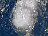
I see the forecast discussion written. I also see the Water Vapor Loop.
http://www.esl.lsu.edu/webpics/goes/Storm/AOI0/latest_wv_loop.gif
The stalemate is over with regard to steering currents i think and the path to the north is no longer blocked... or rather a path towards the Panhandle/NW Florida area...
Canadian also supports this and in the end the may have been right.
That water vapor loop changed drastically over the last few hours. Possibly the moisture itself from the east side of the storm helped to break it down. Not sure, but it's not just about a strong cold front diving down.
It's about the path that is easiest to take... that is what weak storms do..they go with the flow or they go with the easy road... and they try and stay away from sand traps or other negative factors.
Will see how she looks on morning visible.
Anyone's guess is as good as anyone else's right now.
--------------------
http://hurricaneharbor.blogspot.com/
|
MikeC
Admin
Reged:
Posts: 4625
Loc: Orlando, FL
|
|
Models are interesting overnight, pretty much stayed the same, toward central Gulf Coast, and most surprisingly the Euro moved quite east, (To New Orleans).
Debby remaiins relatively unorganized.
|
weathernet
Storm Tracker
Reged:
Posts: 296
Loc: Elsewhere
|
|
Quote:
Quote:
...one to the NNW across S.E. Louisiana (UK), which leaves the EURO as the outlier taking the storm to Texas (and still awaiting its 0Z update)
UPDATE: Well, perhaps the still takes Debby to the Texas coast; 0Z EURO has Debby making landfall in extreme S.E. Louisiana as a 985mb hurricane. Could still drag westward from there, but a significant "right hand" shift here as well.
If in fact if Debby moves N.N.E. and over N. Central Florida as it appears to be doing, I believe post analysis of model discrepancies will bare out that with this particular storm, the had "better initialized" strength & position for each of its more recent runs. Therefore, if Debby were right now a more vertically developed storm and perhaps 150 miles farther to the west, perhaps Debby would now be moving more westward.
|
LoisCane
Veteran Storm Chaser
Reged:
Posts: 1237
Loc: South Florida
|
|
Yeah watched the shift in the models blurry eyed last night or rather than early this morning.
Figures the Euro would shift. Question is does it shift on the next run as well?
As I said, the WV loop showed this becoming an easy path for Debby.
http://www.esl.lsu.edu/webpics/goes/Storm/AOI0/latest_wv_loop.gif
She is still in ORGANIZATIONAL mode, still organizing, we need to remember that.
I do think it's putting the horse before the cart worrying where she will go in 5 days while the West Coast of Florida and the beaches to the North are getting slammed. If twisters form again today, a possibility...she could take a tremendous financial toll on Florida while making landfall further to the North.. around Mobile Bay or even La... though the Florida Panhandle is looking more and more like ground zero.
Discounting the is sort of like pretending it's not raining in Florida. Even if you don't go with it, you still need to keep watching it in the rear view mirror... consistency in a forecast model is worth noting.
It's not just whistling Dixie, it's reading something that the others are not reading or giving emphasis to ..
--------------------
http://hurricaneharbor.blogspot.com/
|
WeatherNut
Weather Master
Reged:
Posts: 412
Loc: Atlanta, GA
|
|
I'm thinking the center fixes from recon this morning are more likely relocation of the center than actual movement. Also the ULL in the western gulf is chugging SW at a good clip now and looks to be weakening. I dont, however, see the ridging on the water vapor loop look like it is pushing in an east/west orientation. Its like Debby is caught directly in the middle of the trough diving SE and the high over TX. I am also seeing more banding like clouds popping up on the western side (not too much), and they dont seem to be getting blown off so quickly like they have been
--------------------
Born into Cleo (64)...been stuck on em ever since
|
cieldumort
Moderator

Reged:
Posts: 2434
Loc: Austin, Tx
|
|
This appears to be the situation. The models did a poor job handling the intensity and location of the ULL in the northwest GOM, which I think ultimately forced Debby more to the northeast, ahead of, and possibly helping delay or prevent, the eastward building of the ridge that the and other models relied on to make their forecasts.
At this point, Debby is so far north that it probably now has a slightly better than 50% chance of being picked up by the digging trough, and as been discussed elsewhere, may go ahead and flip the cone in the next few hours to account for this.
A track across north Florida, or Florida & south Georgia, looks like an increasingly pretty good bet.
|
LoisCane
Veteran Storm Chaser
Reged:
Posts: 1237
Loc: South Florida
|
|
Debby is so close to land her weather is basically making landfall... as in tropical storm conditions are being experienced over a good swath of land...
Even has changed from N at 2 to NE at 6...
look at the weather warnings on the opening page of the site............
models did not do such a bad job, people did a bad job of reading the models... hey everyone makes mistakes, tropical forecasting is not for the faint of heart
the ULL was not weighted as strong as it should have been as everyone was looking north at the front
this is where the water vapor comes in hand
you have to match up all the data and models and if they don't make sense, you are missing something
--------------------
http://hurricaneharbor.blogspot.com/
|
danielw
Moderator
Reged:
Posts: 3526
Loc: Hattiesburg,MS (31.3N 89.3W)
|
|
I have been alerted to a possible track change in the 12Z models.
The , Canadian and UKMET are now indicating a possible track toward the Florida Big Bend area.
GFS and Canadian are now faster with the movement and that would place Debby ahead of the trough.
Waiting to see what the shows in it's 12Z run. (Should be out in a little over two hours.)
My personal opinion is that of Lois'. The major portion of the storm is near or at landfall in the Pensacola / Appalachee Bay area. I'm basing this on storm symmetry and where the CoC would normally be located.
The LLC is still displaced to the west-southwest of the major convection. It had tried to wrap convection at first light but something in the main storm disrupted the process. Most likely an outflow boundary or something similar.
Edited by danielw (Sun Jun 24 2012 01:19 PM)
|
MikeC
Admin
Reged:
Posts: 4625
Loc: Orlando, FL
|
|
Recon found a 77 knot flight level wind recently, in a system like this, it means weather will be extremely haphazard, some areas along the coast may not see much, others may get hammered. I doubt this holds since the system is still pretty unorganized. It does indicate that it's still trying to organize, and may make us miserable for as long as it holds out over water.
|
LoisCane
Veteran Storm Chaser
Reged:
Posts: 1237
Loc: South Florida
|
|
possibly a worst case scenario is she could skim the coast if she can follow the plan and go west... creating havoc across an ever larger swatch of beaches in Alabama and Mississippi. However, she'd have to do that without the weather that is racing inland and hovering over Tampa Bay and other points across Florida.
I do see her visible circulation... but again as said and needs to be said again she is a work in progress
if this all verifies tho.. the has won big time the battle of the models
--------------------
http://hurricaneharbor.blogspot.com/
|
MikeC
Admin
Reged:
Posts: 4625
Loc: Orlando, FL
|
|
Euro has moved to a landfall in the Panhandle near Pensacola 3 days from now.
|
LoisCane
Veteran Storm Chaser
Reged:
Posts: 1237
Loc: South Florida
|
|
question is does it make landfall and then bounce down and retrograde back into the Gulf again......or what?
saw the model, I think it left some long term questions IF you go with the Euro... which left the at the Altar
do you blend that with the and say she moves INLAND... and is gone... or do you believe it lingers around Pensacola Bay and Mobile Bay?
unclear on what it shows for the long term forecast
on the Visible imagery she looks to be trying to wrap moisture and wondering if she can intensify before landfall
--------------------
http://hurricaneharbor.blogspot.com/
|
Ed Dunham
Former Meteorologist & CFHC Forum Moderator (Ed Passed Away on May 14, 2017)
Reged:
Posts: 2565
Loc: Melbourne, FL
|
|
The 12Z UKMet is now in:
UKMet Model
Just about a complete 180 from 24 hours ago. It should be enough to generate quite a revision in the next update.
ED
|
Ed Dunham
Former Meteorologist & CFHC Forum Moderator (Ed Passed Away on May 14, 2017)
Reged:
Posts: 2565
Loc: Melbourne, FL
|
|
I'm leaning toward landfall near Keaton Beach, Florida, in Apalachee Bay around 12-15Z Monday morning (which means that Debby will probably come to a screeching halt at any moment now). 
Given the current displacement of the convection away from the center, additional intensification does not seem likely.
ED
|
GlenJohnson
Weather Hobbyist

Reged:
Posts: 62
Loc: Waldo Florida
|
|
Quote:
I'm leaning toward landfall near Keaton Beach, Florida, in Apalachee Bay around 12-15Z Monday morning (which means that Debby will probably come to a screeching halt at any moment now). <img src="http://flhurricane.bamffl.com/cyclone/images/graemlins/tongue.gif" alt="" />
Given the current displacement of the convection away from the center, additional intensification does not seem likely.
ED
Ok, I've learned a lot from you folk, but I'm still just an IT nerd that works for Macys. What the sam hill is 12-15z? And I've been going with the Florida model for a while. Only problem is, I'm just north of Gainesville, so that put's your prediction just about 90 miles from me.
--------------------
|
Wingwiper
Verified CFHC User
Reged:
Posts: 14
Loc: Florida
|
|
Quote:
Ok, I've learned a lot from you folk, but I'm still just an IT nerd that works for Macys. What the sam hill is 12-15z? And I've been going with the Florida model for a while. Only problem is, I'm just north of Gainesville, so that put's your prediction just about 90 miles from me.
z is GMT, or UTC (Google 'em). EDT = Z-4, so possible landfall between 0800 and 1100 tomorrow morning.
|
Wingwiper
Verified CFHC User
Reged:
Posts: 14
Loc: Florida
|
|
BULLETIN
TROPICAL STORM DEBBY ADVISORY NUMBER 6
NWS National Hurricane Center MIAMI FL AL042012
400 PM CDT SUN JUN 24 2012
...THREAT TO LOUISIANA LESSENS...TROPICAL STORM WARNINGS
DISCONTINUED...
|


 Threaded


