MichaelA
Weather Analyst

Reged:
Posts: 951
Loc: Pinellas Park, FL
|
|
Looking at the 12Z run, it has Debby making landfall near St. Marks on Tuesday afternoon. The 12Z (which has been consistent with the eastward track) has it making landfall closer to Cedar Key late Tuesday afternoon or early evening. Of course, the heaviest weather remains well to the east of the center over West Central Florida. Apparently, we have a few days of periods of heavy rain and gusty winds ahead of us before all of this is over and done with.
--------------------
Michael
PWS
|
danielw
Moderator

Reged:
Posts: 3526
Loc: Hattiesburg,MS (31.3N 89.3W)
|
|
I hate to throw a snag in the forecast. But the new 00Z and BAM Suite take the storm back west toward MS/ LA.
Granted the SHIP and DSHIP are at Tropical Depression wind speeds. It would still take Debby 120 hours or 5 days to reach those forecast points.
I'm still looking at the new guidance. Will update as necessary.
Links are time sensitive and display the latest Guidance
http://www.srh.noaa.gov/productview.php?pil=CHGHUR&max=61
http://www.srh.noaa.gov/productview.php?pil=CHGQLM&max=61
Looking at the 18Z and HWRF they are now considered old.
GFDL makes an initial landfall at the Mouth of the Mississippi River and then bounces over to a second landfall near Gulfport,MS at 992mb.
HWRF makes a single landfall near Orange Beach,AL or the eastern side of Mobile Bay.
GFDL/GHM and HWRF-use nested area
Edited by danielw (Sun Jun 24 2012 09:00 PM)
|
kromdog
Weather Hobbyist
Reged:
Posts: 66
Loc:
|
|
For technical reasons, the "official" landfall is still debatable. Living in Tampa, Debby has landed!
|
LoisCane
Veteran Storm Chaser

Reged:
Posts: 1237
Loc: South Florida
|
|
I've been saying Mobile Bay to Pensacola Bay for days... though agree with many in "spirit" the "tropical storm weather" associated with Debby made landfall in Tampa, Port St. Joe, etc.......and points up and down the Florida coast. A strong squall line/band is moving across Florida with severe weather towards the East coast of Florida.
But, we go with the exact center when we talk "landfall" however...........the problem with messy, poorly formed tropical storms is they don't have the worst weather in an "eye wall" around the center of circulation.
This happens all the time. Sometimes it slides into swampy, low areas and other times it hits densely populated areas....
I wish there was a way to handle tropical storms like this that was different from the way we track and cover hurricanes or well formed tropical storms.
Deaths have been reported across a wide area. Will the name be retired now?
Dry air wrapping around Debby have created one heck of a dry line racing through Florida ...now on it's way to Fort Pierce....
And, suddenly she appears "gone" like "poof" in the night.. but she is still there ....even though she is hard to find.
http://www.ssd.noaa.gov/goes/east/gmex/flash-avn.html
Glad I'm not writing the discussion tonight, can't wait to read it... need good discussion out of the .
A storm that will need to be reviewed in retrospect to learn from the mistakes made...
Tornado Warnings abound currently......
--------------------
http://hurricaneharbor.blogspot.com/
|
dolfinatic
Weather Guru
Reged:
Posts: 129
Loc: St. Petersburg, Fl
|
|
It should be an interesting discussion tonight from . It appears Debby has gone poof. I cant find a circulation anywhere on sats. Of course i am an amatuer and probably am not looking for it correctly. All the same, i am beginning to wonder if Debby survives the night
|
WeatherNut
Weather Master
Reged:
Posts: 412
Loc: Atlanta, GA
|
|
Is anyone else noticing the big convective blowup north of the YP? It seems to be heading in Debby's direction? That reminds me that originally the said this would be a double barrel system
Edited by WeatherNut (Sun Jun 24 2012 11:00 PM)
|
cieldumort
Moderator

Reged:
Posts: 2434
Loc: Austin, Tx
|
|
Quote:
It should be an interesting discussion tonight from . It appears Debby has gone poof. I cant find a circulation anywhere on sats. Of course i am an amatuer and probably am not looking for it correctly. All the same, i am beginning to wonder if Debby survives the night
Debby is still there, but her center has never had much convection to speak of -- thus, because the sun has gone down and we are using IR now, her center is barely visible. That said, she is in a weakening phase at the moment, and even the peripheral convection has waned quite a bit. More than likely, this is transient, and within a few hours to half a day some kind of resurgence of convection will commence.
|
cieldumort
Moderator
Reged:
Posts: 2434
Loc: Austin, Tx
|
|
Quote:
Is anyone else noticing the big convective blowup north of the YP? It seems to be heading in Debby's direction? That reminds me that originally the said this would be a double barrel system
The blowup near the Yucatan is just her tail. However, it is possible that her tail does eventually become the focal point of some brand new TC development (maybe a 10% - 20% chance, IMHO).
It is probably "exploding" at the moment in response to upper air dynamics and dry air causing the line to gust out, producing a gust front that appears to be racing south and southeast, firing convection as it goes. This is not indicative of new development. In fact, that is unfavorable for tropical cyclone development.
|
MikeC
Admin
Reged:
Posts: 4625
Loc: Orlando, FL
|
|
The overnight and Euro runs now take Debby right across Central Florida (over orlando) around wed. night / thursday. Florida won't be clear of Debby until Thursday night with that scenario. The keeps it weak, while the Euro brings it back tuesday/wed.
Beyond that it may move up offshore the east coast and possibly affect cape cod or Newfoundland, which would imply about another 10-12 days of Debby tracking.
What could change this is if the naked swirl dies out and no new center really forms.
|
LoisCane
Veteran Storm Chaser
Reged:
Posts: 1237
Loc: South Florida
|
|
Might I suggest that the first signs of the really being on the money might be a deepening of the system as it's convection hits the Atlantic which is what the kept showing over and over. Well, it showed a few things but basically it wrapped up more after it exited South Florida than in the Gulf.
Something we might see play out. Worth looking for... as it will say a lot as to the forecast down the line.
Other than the forecast of her being anchored for days...
http://www.ssd.noaa.gov/goes/east/gmex/flash-avn.html
I'd watch that and the funktop for any signs of that odd part of the forecast playing out. Because, if it does play out I believe the system could slide up along the coast with one model showing it coming very close to the Outer Banks.
--------------------
http://hurricaneharbor.blogspot.com/
|
kromdog
Weather Hobbyist
Reged:
Posts: 66
Loc:
|
|
The latest Advisory now extends Tropical Storm Warnings south to Englewood, FL.
THE LATEST ENSEMBLE MEMBERS FAVOR AN EASTWARD MOTION
BY ABOUT A 3 TO 1 RATIO. THE NEW FORECAST TRACK REPRESENTS A
SUBSTANTIAL CHANGE FROM THE PREVIOUS ONE BUT IS STILL SLOWER THAN
THE MULTI-MODEL CONSENSUS IN THE SHORT TERM.
|
k___g
Weather Guru

Reged:
Posts: 110
Loc: Leesburg, FL
|
|
Kudos to those who kept faith in the . I caved into the Texas solution many days ago. As I live in Orlando I am happy to see that Debby is not much of a threat any longer.
|
doug
Weather Analyst
Reged:
Posts: 1006
Loc: parrish,fl
|
|
Is landfall occurring on St. George Is. now?
--------------------
doug
|
MikeC
Admin
Reged:
Posts: 4625
Loc: Orlando, FL
|
|
Don't think so, perhaps a big cyclonic loop, and dragging in some convection back in. It did seem to get close, and either an elongated or multiple vortex situation. Still unsure.
|
doug
Weather Analyst
Reged:
Posts: 1006
Loc: parrish,fl
|
|
Yeah, you are probably right.
--------------------
doug
|
Wingwiper
Verified CFHC User
Reged:
Posts: 14
Loc: Florida
|
|
Quote:
Is landfall occurring on St. George Is. now?
I called the SGI state park ranger station this morning at 9AM and there was no answer. I suspect thay have more important things to do than answer the phone right now 
--------------------
Rode out Charlie on Sanibel Island 2004
|
k___g
Weather Guru
Reged:
Posts: 110
Loc: Leesburg, FL
|
|
I guess it is once again time to change the future course, as Debby has obviously blown into the Florida panhandle.
(Actually, it obviously didn't!)
Edited by Ed Dunham (Fri Jun 29 2012 11:31 PM)
|
GlenJohnson
Weather Hobbyist

Reged:
Posts: 62
Loc: Waldo Florida
|
|
Been calling Florida all along, and since I live in Gainesville, I'm extremely glad to see we're dealing with TS and not hurricane. This is really going to fill up the water table, something we've needed for years. Odd that the first two named storms started just north of Jacksonville, and gave us plenty of rain, now we have this. Don't look a gift horse in the mouth. Just sorry I have Dish Network, cause it sure does not work in this weather. Tornado watch till 11, flood warning till Wed, still a lot better than the snow and tornadoes of Chicago.
--------------------
|
Ed Dunham
Former Meteorologist & CFHC Forum Moderator (Ed Passed Away on May 14, 2017)
Reged:
Posts: 2565
Loc: Melbourne, FL
|
|
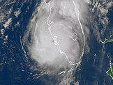
Interesting to note that dry air aloft is really shoving eastward - already over the northern half of the peninsula - and there is very little deep convection left with this system. I'm sure that the dry air has limited the aggressive development of the existing feeder bands. Center now seems to have moved more toward the east northeast over the past few hours although the system is such a slow mover it probably takes at least a half of a day to determine a trend.
ED
|
berrywr
Weather Analyst

Reged:
Posts: 387
Loc: Opelika, AL
|
|
Debby is becoming more and more elongated from ENE to WSW and is near shore and showing some sign of accelerating. There's an interesting feature on the models which splits the vorticity with this system. I wouldn't be surprised if there is a non-tropical low that forms on the frontal system off the coasts of GA, SC and FL. Debby has been a shallow system now for two days and water vapor shows no upper level circulation of any kind above her...I say non-tropical given there is shear from the SW aloft and the longwave trough along the Eastern Seaboard...if and when it weakens and lifts away; what remains might re-acquire tropical characteristics.
--------------------
Sincerely,
Bill Berry
"Survived Trigonometry and Calculus I"
|


 Threaded


