cieldumort
Moderator

Reged:
Posts: 2519
Loc: Austin, Tx
|
|

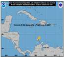
A tropical low pressure system located several hundred miles east of Miami, Florida is being tracked as Invest 97L. This system has become better organized today, and a tropical cyclone may be forming despite low probability odds per .
While 97L is expected to merge with a front later this week and move off to the east or northeast, there is a window of opportunity for the incipient cyclone to head more southerly instead, and impact the Bahamas, Cuba, and locations in that general area.
This is where to put your mid to long range best guesses on potential for further development, intensity, and forecast track. Longer range model output discussions are also appropriate here.
Title edited to reflect upgrade.
Edited by cieldumort (Fri Oct 12 2012 10:19 PM)
|
LoisCane
Veteran Storm Chaser

Reged:
Posts: 1237
Loc: South Florida
|
|
A very typical sort of troubling system that often happens in November, however this October seems to be last years November... " incipient cyclone to head more southerly instead, and impact the Bahamas, Cuba, and locations in that general area."
Well said... looks as if it is beginning to separate from that front, the new one is moving across the country but might be too little too late... and will it dip DOWN enough to grab it?
Too much going on there to ignore http://www.ssd.noaa.gov/PS/TROP/floaters/97L/flash-vis-short.html
--------------------
http://hurricaneharbor.blogspot.com/
|
cieldumort
Moderator

Reged:
Posts: 2519
Loc: Austin, Tx
|
|
Invest 97L has become Tropical Depression #16. Sixteen is presently centered near 25.5N 72.5W, and has been drifting ever so slowly to the south with an expected turn more to the southwest; however, models are somewhat split, with several in the group taking TD 16 off to the northeast, and others suggesting variations of a loop.
Shear over TD 16 is not terribly prohibitive for some further strengthening in the near term, but is forecast to deal a death blow to the cyclone within 48 hours. Still, it is worth noting that 97L/16 has been rather tenacious.
|
LoisCane
Veteran Storm Chaser

Reged:
Posts: 1237
Loc: South Florida
|
|
16 is currently Tropical Storm Patty... and am curious why the models stay and play with her longer than the forecast does...though they wrote the forecast earlier. 11 PM should be interesting.
http://moe.met.fsu.edu/cgi-bin/cmctc2.cg...;hour=Animation
They are all Cuban bound...for the most part with the LBAR going NE
http://icons-ak.wunderground.com/data/images/at201216_model.gif
Edited by Ed Dunham (Thu Oct 11 2012 11:56 PM)
|


 Threaded


