After a bit of activity last week, both systems fizzled out and now there isn't as much to watch in the tropics this week.
There is an area of convection in the Gulf of Mexico, southwest of Florida that will need to be monitored because of the time of year, but there are no models currently developing the system. If this persists through tomorrow, things may change.
Outside of this, not much going on in the Tropics, which is very unusual for this time in August.
It is indeed unusual for the week of 19-25 August to not have a named storm. In the past 50 years it has only happened 7 times: 1967, 1968, 1977, 1978, 1982, 1997 and 2002. A very weak cyclonic curvature is noted near Cape Sable - but that's it for the entire basin.
ED
The GFS does hint at a system off the African west coast in a few days, however, its probably developing the system that was at 10N 5E at 20/18Z. That however is no guarantee since stronger systems have been noted over the African continent in the past couple of weeks and many of them didn't develop. Time to wait and look for model consistency from run to run, but the basin looks uncommonly quiet for the next few days. Any model output beyond that is fodder for the Lounge.
ED
I'll give this a 10% chance just for being in the Eastern Caribbean.
Cyclonic curvature noted in the low and mid level clouds. Currently a moderate sized convective complex is in the NE sector of the complex and has what appears to be something close to a CHT- convective hot tower. CHT's are basically turbochargers or power cells in developed tropical cyclones. I've been watching this system for several hours after local sunset and it seems to be holding together, to a degree.
Moderately dry air to the west of the system and dry air to the north of the system.
TROPICAL WEATHER DISCUSSION
NWS National Hurricane Center MIAMI FL
805 PM EDT TUE AUG 20 2013-edited~danielw
....IN THE UPPER LEVELS...A
SMALL UPPER LEVEL LOW IS CENTERED OVER THE NW CARIBBEAN NEAR
20N84W. A SMALL UPPER LEVEL HIGH IS S OF HISPANIOLA NEAR 15N76W.
UPPER LEVEL DIFFLUENCE E OF THIS HIGH ENHANCED THE CONVECTION E
OF THE TROPICAL WAVE. EXPECT OVER THE NEXT 24 HOURS FOR...
CONVECTION OVER THE MONSOON TROUGH TO CONTINUE...AND FOR THE
TROPICAL WAVE TO MOVE W WITH CONVECTION.
NHC is giving this Low a 10% chance at becoming a tropical cyclone in the next 48 hours to 5 days. That percentage will probably increase with the 8 PM Tropical Weather Outlook.
First image is centered on the Center of Circulation for the system. Notice the overshooting cloud spike (small grey dot) just west of Tampa,FL. Small CHT?
Water Vapor image. Small yellow dot just west of Tampa. Cloud spike.
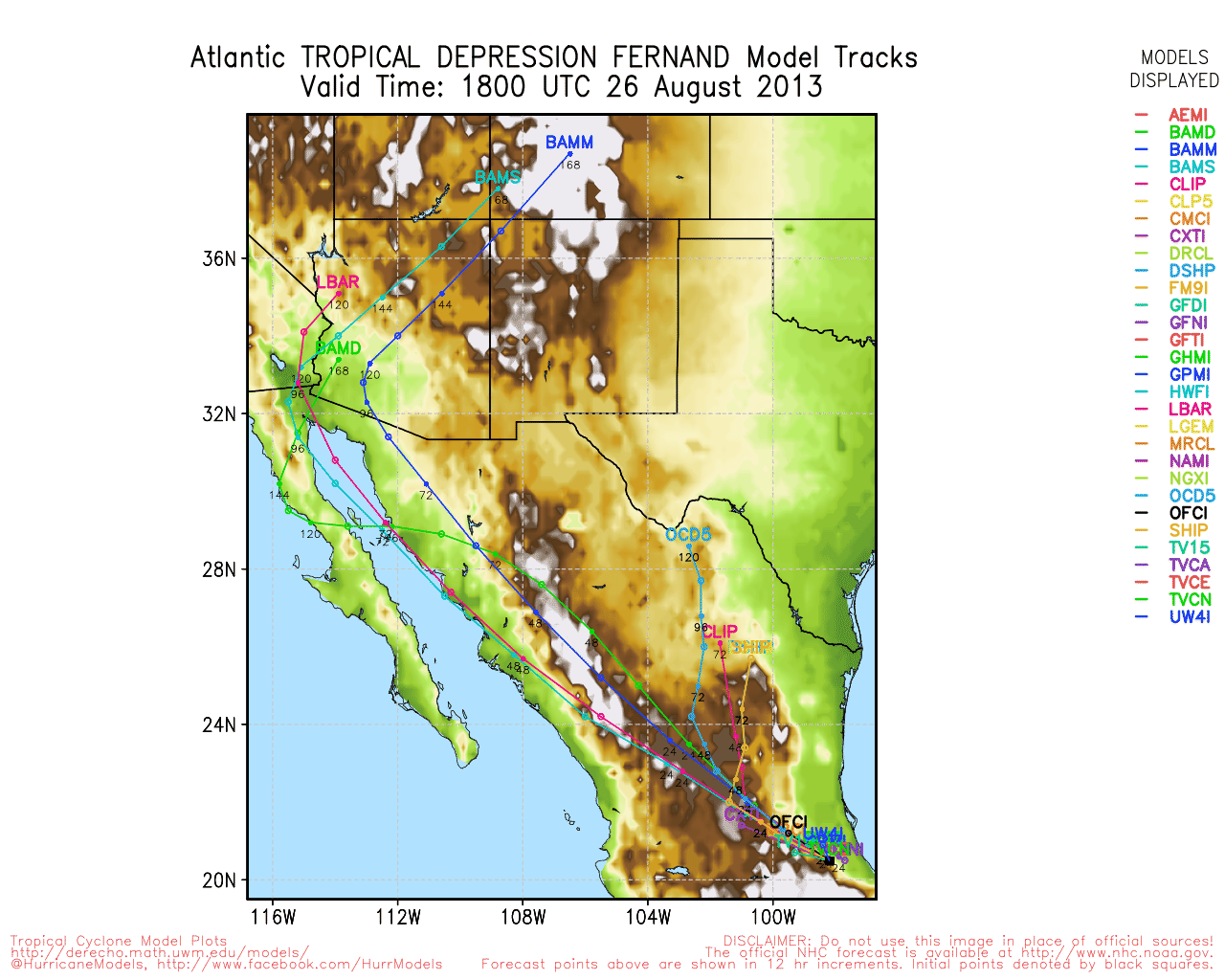
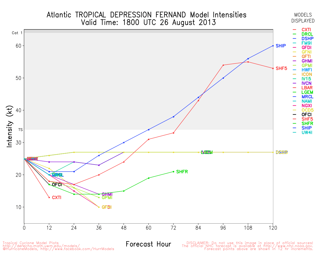
It appears 95L in the Bay of Campeche is close to TD status if not already there. It doesn't have much time over water, but it's making the most of it so far.
Looking at the GFS next week might get interesting way out in the Atlantic. I am hoping the model is wrong or we get a few Fishes which is what i hope they will be.
Forum Permissions
You cannot start new topics
You cannot reply to topics
HTML is disabled
UBBCode is enabled
Rating:
Topic views: 6607
Note: This is NOT an official page. It is run by weather hobbyists and should not be used as a replacement for official sources.
CFHC's main servers are currently located at Hostdime.com in Orlando, FL.
Image Server Network thanks to Mike Potts and Amazon Web Services. If you have static file hosting space that allows dns aliasing contact us to help out! Some Maps Provided by:
Great thanks to all who donated and everyone who uses the site as well.
Site designed for 800x600+ resolution
When in doubt, take the word of the National Hurricane Center


 Threaded


