cieldumort
Moderator

Reged:
Posts: 2531
Loc: Austin, Tx
|
|

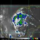
Above: Recent IR4 Image of Disturbance In the NW Caribbean
A disturbance mostly in the mid-levels has slowly been developing in the western Caribbean, and is now given a 60% chance of becoming a tropical cyclone within the next five days, per .
The system presently has limited organized convection, but intermittently good cyclonic flow.
Movement is to the northwest at around 10 MPH. The disturbance is expected to cross the Yucatan, and enter the southwestern Gulf of Mexico later in the week, where it should have a better chance of getting a name.
This is where to put mid to long range thoughts on this feature's potential for further development, intensity, and forecast track. Longer range model output discussions are also appropriate here.
Title edited to reflect upgrade to Tropical Storm.
Edited by Ed Dunham (Sat Sep 14 2013 11:25 PM)
|
Random Chaos
Weather Analyst

Reged:
Posts: 1024
Loc: Maryland
|
|
Firstly, anything in the gulf has to be watched. That said, longer range models aren't bringing it too far north - not even really Texas. Doesn't mean it won't happen, especially if it develops in the nearer term rather than longer term.
I am watching it closely while being distracted by the beautiful pinwheel spinning on the eastern side of my wide-view Atlantic IR loop.
|
doug
Weather Analyst
Reged:
Posts: 1006
Loc: parrish,fl
|
|
I know the experts are stating this will move slowly westward. But the dynamic now suggests, to me at least, for more northward motion of the energy related with it. It depends, I guess on the relative strength of the persisting mid-upper level cyclone to the NW of the system which cannot but influence this system. It will either facilitate outflow on the west-northwest portion of the system, or produce a westerly shear which will inhibit the development.
12:50 update: the system is moving rather deliberately to the west but is being sheared by the sw'ly flow aloft...the LLC is exposed...
--------------------
doug
Edited by doug (Thu Sep 12 2013 12:53 PM)
|


 Threaded


