CFHC

Reged:
Posts: 163
Loc: East Central Florida
|
|
We've got two systems, that could develop, one southeast of Cape Hatteras, North Carolina (the longer shot) and one near Bermuda (Which may be a depression today).
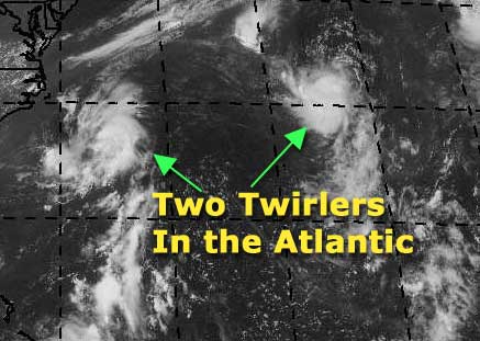
The Navy already has an eye on them, and so do I. The one near Bermuda is a candidate for the first depression of the year. It won't last long because of a low nearby, but it is something to track.
Let's throw up some chances:
On my development scale, where is the system southeast of Hatteras now?
code:


forget it) 0 1 2 3 4 5 6 7 8 9 10 (sure thing)


         [--*-------------------]
This one has a much lower chance to form, although it is showing some signs of spinning. Definitely don't want to write it totally off yet...
As for the Bermuda System..
code:


forget it) 0 1 2 3 4 5 6 7 8 9 10 (sure thing)


          [----------*-----------]
A much better chance, overall, and my personal choice for first almost if not complete tropical depression of 2002.
We'll See...
NASA GHCC Interactive Satellite images at:
North Atlantic Visible (Daytime Only), Infrared, Water Vapor
Some forecast models:
NGM, AVN, MRF, ETA ECMWF
DoD Weather Models (NOGAPS, AVN, MRF)
AVN, , , , , UKMET
Other commentary at Mike Anderson's East Coast Triopical Weather Center, Accuweather's Joe Bastardi, Hurricane City, Gary Gray's Millennium Weather, Even more on the links page.
- [mike@flhurricane.com]
|
Matthew
Unregistered
|
|
That 100 percent are first system as of right now and the has it as 93L. The d number is 1.5 that is 25 to 30 mph wind and the low leavel yes I think it a low leavel spin is just on the northern enge of the thunderstorms this low is looking like there some outflow and I will say that we got are system we been looking for a long time this storm even starting to look like a tropical storm but you all now that the nation hurricane center will just sleep on this and never give it a chance so don't but your hunder dollar bill on it because if they see it they might but the way there going it going to take a hurricane to hit the u.s before they might start waking up so that what I think the chance are low but all say tropical system number one and that all I can do as of right now.
|
Matthew
Unregistered
|
|
I was wrong to say that the nation hurricane center is slow and normal sleeps on these storm. Because that the 5:30 update side that we might see a storm or some thing form by tonight and there a few other the atlantic is firing up so get ready and let the storms begin to form and hit the u.s but stay away from texas they are having killing rains. Back to the tropical weather there also a spin to the southwest and a another southwest to that one and a low leavel low and the gulf of mexico. There is another one dieing to the northeast of the one the nation hurricane center is forecasting to became a tropical system so that the tropics so there no one else on this site. It looks like won'd there nothing there 100s of post and now there now and the tropical atantic is going off?
|
Anonymous (HF)
Unregistered
|
|
a'right. the on the rated system is up to 1.5 as of 1745z, but its convection and low level center are a bit disjointed. theyre sort of wanting to move northeast at different angles, with the convection now clinging to the southern edge and looking quite healthy. hasnt classified it just yet, theyre playing it safe, just alluding to the fact that they may choose to later. i was around half confident earlier, now just a little lower... just dont see this thing getting much better organized.
the hatteras system is looking better than i expected, with a good are of low pressure at the mid levels but little at the surface. a narrow upper trough has dug in to the east ahead of a burgeoning upper high, and is bringing in southwesterly shear.. i'm thinking that it will turn around to northeasterly shear by tomorrow. this is the next upper system that will be rolled under and retrograde down across the gulf. the system is slowly drifting NE.. expect it to turn north later.
nhc isnt bothering with the northeasternmost system.
then theyve also cared to mention the surface trough setting up in the NE gulf, in relation to the upcoming cutaway upper trough. it's weak and not near organization, but will take a few days to move west across the gulf. so basically, all of a sudden, several things of interest are going on.
didnt expect anything to happen until late july, now several things are threatening that idea.
HanKFranK 3.07 aiken, sc 2148z05july
|
Anonymous (HF)
Unregistered
|
|
that poll should read july 9th.
|
ShawnS
Storm Tracker
Reged:
Posts: 226
Loc: Pearland,Tx
|
|
I need some help with something. I can't remember when I said the first tropical system would pop up. This was back when we all were making our predictions on when we thought the first storm would be. I think I said it would be July 6th or 7th but I can't remember. John C., can you please let me know exactly what date I put? ALL I CAN SAY IS THAT THE PEOPLE IN THE CENTRAL PART OF THIS STATE DO NOT NEED ANY MORE RAIN!
|
Anonymous
Unregistered
|
|
tropical scale a t.d is a will formed low leavel center and some thunder storms this even so the thunder storms are kind of falling apart should of been close to tropical storm and the this is tropical low is weak low pressure and or off a tropical wave are forming from thunder storms and and the mid lat from mid or upper leavel low this low has a warm core and some thunderstorms and a nice spin even so it might be geting shear and so it needs to be upgraded as soon as can be or it going to die and neaver get it chance so the north most system is over cold water and neaver got it chance give this one and as for the one of the coast line some time and the next day or so that might be another system so tropical low lose spin tropical.d tight spin so give its number and start is quit hurricane season off fast so we can see some storms.
|
Kevin
Weather Master

Reged:
Posts: 524
Loc: EC Florida
|
|
It appears Arthur may finally rear his little head out. The system northeast of Bermuda has now developed an LLC on the southern edge of the convection, which btw is holding together very well. Sheer is light SST's are going to be warm for a little bit longer and I believe TD 1 will form tonight or early tommorrow. It may become Arthur for a very short time period. 
A poll... 
kabudd87@hotmail.com
|
Matthew
Unregistered
|
|
100 percent a storm will form by morning and at lease 50 percent for arthur by morning and this storm is really spining and think with the 10:30 they might say that we got are tropical system. start the updates
|
Matthew
Unregistered
|
|
some things telling me that this storm is going to haved to form a eye to be classifed as a tropical system with 35 mph winds they just will not do it 10:30 they put up a fight that the system has no low leavel center that 100 pounds of clouds and fish there talking about. 
|
Anonymous (HF)
Unregistered
|
|
these systems should be named 93L and 94L based on previous order, and the page has them this way.. the NOAA page doesnt. 90 and 91, it says. thus the confusion.
for 93L i dont think it matters. the convection has become disjoined, and the low level circulation is further elongating as it begins to merge in to the digging deep layer cold system to the north. wont bother with it anymore.
94L is a different story. it is further south and conditions overhead are going to improve. an upper jet is splitting to its northwest, and this diffluent jet is forecast by some models to come closer SE.. this could provide ideal ventilation. right now some of 94Ls fire is stolen by a big complex over the eastern carolinas and another along the frontal zone to the north. this one i think will make a development run tomorrow.
other interests.. further south of 94L is some spotty tailing convection under tranquil upper conditions.. it could at least spawn another complex to worry about.
nogaps is developing a closed gulf system next week now, and all are moving a surface disturbance west to texas. considering the ongoing flood situation, a tropical system could really complicate things. so watch the light shear zone in the NE gulf, where the upper system is setting up. development up there would almost surely mean a landfalling gulf system.
we could go active tomorrow, it's a clear possibility.
HanKFranK aiken, SC 0409z06july
|
Matthew
Unregistered
|
|
As for droping that 93l that was to early I was looking at some of the lates and it look like alot more thunder storms formed on top of the low and this system will more likely be t.d one and the morning.
|
Matthew
Unregistered
|
|
The nation hurricane center could upgrade this soon.
|
Anonymous
Unregistered
|
|
fall apart the nation hurricane center will not make this a tropical.d and this will be in the upper low and 24 hours so sorry and no storm this july and think it will be 12 storms but that could be very high.    
|
ShawnS
Storm Tracker
Reged:
Posts: 226
Loc: Pearland,Tx
|
|
It looks like the has a recon scheduled to possibly check out the activity in the gulf tomorrow. Any thoughts on this?
|
Anonymous (HF)
Unregistered
|
|
nhc/tpc has gone and dropped some stuff prematurely.
93/94L or 90/91L, as they were being tracked under both names, were dropped this morning, with the being given as 1.5 on both at 0545z, then not reissued. 90/93 lost its convective nature over cooler waters, and 91/94 supposedly merged with a front. funny how today it looks as good as ever.. more pressed against the front than part of it. anyhow that sort of surprised me this morning, and now the thing is still there.. well, everybody voted that they wouldnt be classified.. and they arent. maybe they will post analyze one or the other as a subtrop or something much later on.. but i sort of doubt that (like the system in mid august of 2000).
there are two other things going on, as for some reason the empty, sheared basin suddenly came to life a few days ago and has multiple convective complexes at mid latitudes that arent falling apart.
last night one formed southeast of bermuda, and is still there, along with a little twist that may be mid level or surface, the Lord only knows. i expect nothing of it, like its brethren, as it may be a weak system that will never be classified.
the most interesting area is the gulf. convection is continuing there, and there is already a broad surface trough in the area. the recon will only go out tomorrow if it starts looking more ominous, right now it isnt all that threatening.. but it has a couple days to become so. regardless this will be another big batch of tropical moisture ready to come calling on texas, just where it isnt needed.
there are other less interesting areas of convection near florida, cuba, the bahamas. nothing is showing signs of development there.
still plenty going on, but nothing developing in a hurry.
not much noise from the regulars on the site, guess the 4th weekend has everybody out and about.
HanKFranK aiken, SC 2133z06july
|
BabyCat
Weather Guru
Reged:
Posts: 150
Loc: New Orleans, La.
|
|
Hopefully, it will head further south then the initial projections, IF it develops.
|
Anonymous
Unregistered
|
|
Pressure have consistantly fallen in the gulf south of New Orleans for the last five hours we might have a live one on our hands. Any comments?

|
Ed Dunham
Former Meteorologist & CFHC Forum Moderator (Ed Passed Away on May 14, 2017)
Reged:
Posts: 2565
Loc: Melbourne, FL
|
|
HankFrank was right about 94L. It sure looks well organized this evening with a good and the front hasn't captured it yet. Doubt that the will do anything with it though. Convection in the Gulf has died down somewhat, but this system will need to stew for a few days.
Cheers,
ED
|
Frank P
Veteran Storm Chaser
Reged:
Posts: 1299
|
|
Latest bouy observations in the GOM don't really show any significant low pressures, (lowest I could find tonight was 1013.5), same is true for wind velocities... IR not impressive either, so if anything does develop it will be really slow to occur.... regardless, it might be the only thing to watch with any interest for the next few days...
Remember all, its still early July, and we had only 20 named storms in the past 116 years... so we've only got about a 17% chance of any development during the first 10 days of this month.....
|


 Threaded


