cieldumort
Moderator

Reged:
Posts: 2517
Loc: Austin, Tx
|
|

A distinct second area of low pressure also associated with the broad monsoon trof that 91L has been tangled up in, is now being tracked by . This Low has been tagged Invest 92L.
92L's odds of development in the near term are marginal, but increasingly favorable beyond 48 hours, with some models' runs outright bullish. Movement is forecast to be to the west, or west-northwest.
This is where to place best guesses on this wave's development potential. The sharing of medium to long range model output is also encouraged here.
Aug 27 4:30PM EDT Edit: 92L has become TEN and the title has been updated. Advisories coming.
-Ciel
Edited by cieldumort (Sun Aug 27 2017 04:34 PM)
|
MikeC
Admin
Reged:
Posts: 4672
Loc: Orlando, FL
|
|
I won't be back in full action until next week, but this one has me a bit more concerned than the others for a US impact based on model trends, and the HWRF scenario. It'll be interesting to watch over the next week, euro keeps it weak, but I think its under doing it near the Bahamas.
|
Prospero
Storm Tracker

Reged:
Posts: 269
Loc: Gulfport, FL
|
|
FLhurricane.com has a lot of viewers like me, yet who do not post as much as I do, that look here for the latest info. In fact, I have sent many people here over the past 13 years and we all discuss what we see here when we talk about future possibilities.
That said, in Florida we are watching the plots of 92L which appear to be in agreement at this point that there is a possibility of something coming to visit. But without the experienced and professional members of these forums posting, we who are not professionals can only guess at what kind of time frames we are seeing and whether or not something may be in our future.
I know we are some time out (a week or so?), but even some discussion gives us a bit to work with. Granted, the discussions we have outside of this website might be just a topic over dinner with family, or a few beers with friends, but right now we are turning to other sources for the most current info when FLhurricane.com has always been the most up-to-date and accurate. I was surprised at the WeatherUnderground information on Weather Channel last night when I thought I was in the know on FLhurricane.
We miss Ed, but let's keep this going for him if nothing else.
I pay monthly for weather apps; RadarScope, SailFlow, and other storm geek services. Plus I have my own weather station and live streaming weather cams. I would pay for or support FLhurricane to be a bit more active.
Would be a sad day to see it go away...especially for we who live in Florida.
--------------------
Gulfport Florida Webcam - Gulfport Florida Weather Station - Clearwater Beach Cams
Edited by Prospero (Thu Aug 17 2017 09:34 PM)
|
cieldumort
Moderator

Reged:
Posts: 2517
Loc: Austin, Tx
|
|
Going to go deep into "Lounge talk" on 92L here. Take all of this with a few thousand pound grains of salt. We are still a long way off from potential US impacts from 92L.
It appears likely that 92L may already be a small tropical cyclone tonight, or at the very least, right on the cusp. The operative word is small, and this could have big implications going forward.
As discussed on Weather Underground's WUTV (Weather Channel), a possible shear monster lies in wait for 92L ahead, not to mention, robust pockets of dry air. However, models in aggregate suggest that 92L will travel within enough of a protective envelope to fend off the worst of it.. which would be more believable if 92L wasn't a small cyclone.
The track ahead for 92L into the Bahamas assumes that the system will weaken, at least some, and perhaps to the point of dissipation (though by no means the most likely scenario), or stay weak. This is potentially more unsettling than not. A tenacious system such as 92L has been, to then become a small TC, weaken - or even devolve back to an open wave, but doing so much closer to Florida - is never a good thing.
Over the next 48 hours, there is a window for 92L to not only gain size, but also intensity, and with any luck it may begin to feel the pull of the ULL to its northwest and gain enough latitude that it has a chance to recurve. (IMHO, the odds of this are under 15%, but far from zero).
However, other more likely scenarios are very troubling:
- Small TC with potential for rapid changes in intensity is kept or made weak enough that it in fact tracks into or near the Bahamas, but primarily not over land, and poses a real risk to Florida and possibly the Gulf states later next week (IMHO, 35% odds).
- Becomes larger in size and resists rapid weakening, but never strong enough to recurve. A mid-size strong tropical storm or hurricane, strengthening, as it rakes the Greater Antilles or nearly does so, and possibly still on its way to Florida and/or the Gulf (IMHO 25% odds)
Other scenarios exist and have some model, or at least ensemble member support, but as my own personal opinion goes, the rest all share what is left of the remaining 25% of the pie, and at this time do not seem plausible enough to give lounge time to. One of those of course is complete dissipation.. which is indeed supported by some models' runs.
Here's a breakdown of the Aug 18th 0z runs, so far
CMC
(You may have read elsewhere why I am giving more attention this year for systems that have good TC DNA)
Sends a deepening and mid-size hurricane across the Bahamas and then has it perform a Fujiwhara loop and then runs up the eastern seaboard, induced by the passing of a well-developed mid-size hurricane (93L) to its northeast... This assumes a lot. Maybe too much. While very plausible that 92L becomes a deepening and larger tropical cyclone over the Bahamas around the 25th of August, it is far from clear if (93L?) will even develop nearly that much, let alone at all.
GFS
Poorly initialized. This 'new and improved' has, IMHO, been less than stellar this season. The 18 0z run fails to even recognize that 92L is now very possibly a tropical cyclone, or will soon be. Keeps 92L as a weak wave and washes it out entirely before whatever is left of it crosses Florida as an afternoon shower. - I would call this a FAIL run.
More analysis of the models' analysis to come..
GFS Ensemble Members
There is zero model support from even a single ensemble member for anything more than 92L becoming a TD at this point. ALL wash it out in the face of dry air and shear. Again, it does appear that there is a bias for poor initialization, but even among members who handle 92L's current state better - 100% wash it out.
ECMWF
Euro, like the , never really develops 92L at all, and also washes it out into a passing rain shower over Florida later next week. So, being that and Euro are in lockstep on this solution, maybe there really is something to that. On the other hand, they were both very muted on 91L until recon flew in. Now the Euro has 91L (Harvey) heading to Tx as a seriously deepening Hur.
ECMWF Ensemble
Suggests 92L may try to redevelop in the northern Gulf
More model analysis to come...
HWRF
After briefly allowing for 92L to be a strong TD or low-end storm over the course of the past twelve hours (good initialization), the HWRF then weakens it and primarily keeps it as a very sloppy TD, or open wave, though frisky at times, up until the Bahamas. Only over the Bahamas does it start to slowly reorganize - perhaps a low-end TS upon hitting the Straits of Florida.
HMON (GFDL's replacement)
Like HWRF, allows for 92L to have been a TD/TS for the past twelve hours or so, and like the HWRF, then weakens it - but generally even more so, and never brings it back. Open wave, then death.
NAVGEM
The Navy initializes 92L as a sloppy wave at best, and sends most of the wave, or its remnants, to Florida for a shower or two. Apparently a piece of 92L breaks away to merge with (93L?) and cranks that up (mostly 93L at that point) well offshore of Florida.
UKMET
Initializes and keeps 92L as an open wave. Crosses Florida by late next week as a very weak wave, but suggests development is possible in the Gulf.
In summary, not a lot of model support for 92L to develop at all from the 18/0z runs. What is consistent, is a path towards Florida, which is why, given the wave's DNA, means it must continue to be watched. Should 92L find itself, even briefly, in a favorable environment if and once closer to the state, it could quickly organize (or further ramp up - depending on its state) and pose a threat.
Edited by cieldumort (Fri Aug 18 2017 10:51 AM)
|
JMII
Weather Master

Reged:
Posts: 546
Loc: Cape Coral & Margate, FL
|
|
A lot of "ifs" here with 92L. Given its small size, high shear ahead and some dry air its going to have to fight to stay alive. Its clearly on the pay attention to list but we got awhile before we get any good data for it.
--------------------
South FL Native... experienced many tropical systems, put up the panels for:
David 79 - Floyd 87 - Andrew 92 - Georges 98 - Frances 04 - Wilma 05 - Matthew 16 - Irma 17
Lost our St James City rental property to Ian 22
|
cieldumort
Moderator

Reged:
Posts: 2517
Loc: Austin, Tx
|
|
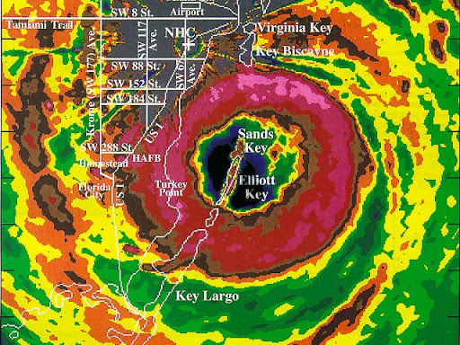
Newer site users or newer residents of Florida may wonder why some 'old timers' are seeming to get a little worked up over 92L. Well, there is some history involved, and it can be summed up easily in one image and some advisory text. Cr. Bryan Norcross @TWCBryan
" target="_blank">Bryan Norcross Twitter
Below: Aug 18, 1992 Tropical Storm Andrew

As noted in several replies above, it is still much too soon to begin placing bets on 92L's future track and intensity. However, 92L falls in the location/intensity/forecast track/time of year box that for residents of Florida means keep watch, and keep watch closely.
|
JMII
Weather Master

Reged:
Posts: 546
Loc: Cape Coral & Margate, FL
|
|
Not to cause alarm but this caught my attention this AM... another Andrew tie in: Eclipse 'Cane!
https://www.usatoday.com/story/weather/2...-sun/579047001/
the alignment is actually more on the next wave and not 92L - but it is a super rare, odd pairing for sure.
Andrew was weak as it moved N, then entered the Bahamas, cranked up and made a bee line due west for Homestead. It also stayed small (compact) the whole time. In retrospect this behavior is the opposite of what normally occurs: weaker storms tend to head west, then as they gain strength they get pulled north.
One of the great things about the is how consistent their communication and formatting is. Here we are 25 years later and that old message still holds up.
--------------------
South FL Native... experienced many tropical systems, put up the panels for:
David 79 - Floyd 87 - Andrew 92 - Georges 98 - Frances 04 - Wilma 05 - Matthew 16 - Irma 17
Lost our St James City rental property to Ian 22
|
doug
Weather Analyst
Reged:
Posts: 1006
Loc: parrish,fl
|
|
Since we are on a forecast lounge and speculation is expected, I see 92L this way based on current sat. representations (see the WV loop). It is highly possible that the current low level circulation that exists in 92L could be inhibited by a very vigorous ULL that seems to be digging down into the circulation around the low.. it is also possible that 92L could slide westward beneath this upper low. In short, the future of this system should be clearer in the next day or so and seems to be dependent on its interaction with that ULL. Should it survive that then a more real threat will exist. I think this is the factor that has kept the two more "reliable" models cautious on this system...
--------------------
doug
|
Bev
Weather Guru

Reged:
Posts: 132
Loc: Port Charlotte, FL and Abaco, ...
|
|
Quote:
Going to go deep into "Lounge talk" on 92L here. Take all of this with a few thousand pound grains of salt. We are still a long way off from potential US impacts from 92L....
Wonderful information, thank you!
--------------------
Survived Charley at Cat 4 under a staircase. Won't do that again. I watch SW Florida and Abaco primarily.
|
doug
Weather Analyst
Reged:
Posts: 1006
Loc: parrish,fl
|
|
92L continues to be affected by upper lows. The one to its NW is infusing dry air into its circulation and causing some shear. This system is moving westward and its influence on the tropical low may continue for several days. The has lowered the expectations for development to 40% or by a third this morning. It must still be monitored closely however.
--------------------
doug
|
Prospero
Storm Tracker

Reged:
Posts: 269
Loc: Gulfport, FL
|
|
Thanks for the latest participation everybody! 
So it's getting beat up a bit, but not done yet. The sats show the damage, but it doesn't seem to be destroyed yet, Yes we want it to go away, right?
OK, I'm the inappropriate one who loves a storm. Yes, please no harm, no damage, no financial cost, but outside of that, I love a beautiful spinning tropical storm and every wave I see I wish it would become an sight to behold. (Disclaimer: until it affects somebody.)
I was born to be a meteorologist, even at 7 or 8 years old in Colorado Springs I was predicting hail storms and blizzards. I would be outside staring at the sky examining every cloud, and breeze. And that started as young as 4 or so. Why I didn't pursue that path, I don't know. But I started fixing things (anything that had moving parts) as a kid and ended up fixing machines and in I.T. since 1978. Now mostly web programming these days.
Maybe since I am not a professional meteorologist I can freely "wishcast" and fantasize about being Jim Cantori in the upper right quadrant of the eye wall of a Cat 2 or 3 storm, clinging onto anything that keep me from flying away...

Yea, I know, sick, but I bet none of us would on this website if we didn't have a "little" bit of that in us!
Anyway, thanks again and let's keep this site as the best.
--------------------
Gulfport Florida Webcam - Gulfport Florida Weather Station - Clearwater Beach Cams
|
Robert
Weather Analyst

Reged:
Posts: 366
Loc: Southeast, FL
|
|
All good info, love the pic of Andrew, not many around from then, even so that picture shows a more robust system with system in carribean barely a wave, not saying this wont move a abit wind but when i expect a category five i like to a see a definitive storm hitting bad shear and coming through the other side north of purto rico.
How ever i noticed some long range out put like , navg gem, , showing a stall and then caught and pullled out before being blocked and possibly heading north north west toward new enlgland, or newfoundland.
Also harvey is suffering, the major that was supposed to be going off in the gulf same day 92L comes ashore, i just dont see both ocupying the same space.
Also apears a trough over the south east may prevent 92L from getting into the gulf, so rain tuesday with northeast winds 20-30knts, maybe gusts to 35knts.
Wednesday southwest or west depending where you are.
Then it pulls out Wednesday night and deepens gets trapped turns north and threatening land north.
Edited by Robert (Sun Aug 20 2017 03:30 AM)
|
doug
Weather Analyst
Reged:
Posts: 1006
Loc: parrish,fl
|
|
92L has escaped the tyranny of the ULL and a small anit-cyclonic flow is allowing some evacuation on its northern quadrant. The issue now is the dry environment that surrounds the system. A small channel of tropical moisture is being drawn up from the SE but that environment is not plentiful. This is why the keeps a 20% chance of development. The system will be in a better environment in a couple of days
--------------------
doug
|
ljmax
Registered User

Reged:
Posts: 4
Loc: Ocala
|
|
I haven't posted in a few years but this thread got my attention. I was living in South Florida when Andrew came roaring through. I was living at the Dade Broward County Line and the highest winds we saw were a steady 125 - 130mph with gusts above 155mph. The power was lost about an hour after Andrew hit so the entire night was for the most part powerless. I didn't sleep and was listening to my battery powered radio. The DJ said The Miami Hurricane Center had to be evacuated and initial reports coming in said Homestead was gone.
I was a F&I Manager for a large car dealership located near the county line and drove to check it out in the morning. There were 3 large plate glass windows shattered in the showroom and the entire detail area out back was destroyed. There was no power and we did not open however the next day we did. If you can believe it a guy came in and bought a Mitsubishi 3000GT. I told the owner something was not right with us being open and 25 miles south of us people lost there homes and were in dire straits. He told me he was already on it and that he had sent two tractor trailers loaded with supplies to the general Kendall and Homestead area. I sincerely hope this current storm is not another Andrew waiting to happen. 
--------------------
Never argue with an idiot as they will only drag you down to their level and beat you with experience!
|
doug
Weather Analyst
Reged:
Posts: 1006
Loc: parrish,fl
|
|
IMO the ubiquitous dry air surrounding what remains of the low will prevent any thing of consequence with this system...pure opinion not a prediction.
--------------------
doug
|
JMII
Weather Master

Reged:
Posts: 546
Loc: Cape Coral & Margate, FL
|
|
92L is a mess this AM, doubt anything will come of it based on its current appearance and surrounding environmental conditions.
--------------------
South FL Native... experienced many tropical systems, put up the panels for:
David 79 - Floyd 87 - Andrew 92 - Georges 98 - Frances 04 - Wilma 05 - Matthew 16 - Irma 17
Lost our St James City rental property to Ian 22
|
Prospero
Storm Tracker

Reged:
Posts: 269
Loc: Gulfport, FL
|
|
Well if it does come together, there won't be a lot of time for people to prepare if they haven't been paying attention.
What is there is starting to show up on the Gulf of Mexico sats already.
--------------------
Gulfport Florida Webcam - Gulfport Florida Weather Station - Clearwater Beach Cams
|
cieldumort
Moderator

Reged:
Posts: 2517
Loc: Austin, Tx
|
|
Several days ago 92L had what looked like a well defined low level circulation embedded within deep convection. This lasted for roughly 12 hours or so, with a little on-and-off shortly thereafter. During this entire time the system was missed by Scatterometer passes, and not sampled by recon, so we may never know if 92L was another short-lived storm. But the point worth making here is that the system has had a little more going for it than a garden variety wave.
This morning, Aug 21, it's not looking as healthy as yesterday. Maybe it's being eclipsed by the prospect of Harvey regenerating and becoming a hurricane in the Gulf, or maybe it's other skyward news of the day, and models may have backed off some, once again, on 92L's prospects. For the time being, at least.
I don't mean to throw too much shade on 92. The wave actually does have at least two persistent areas of mild low to mid level rotation associated with it *cough* sloppy *cough*, and conditions may become favorable 'just enough' for one of these (possibly even two eventually, however unlikely that is), to spin up into something more. But an Andrew over Florida, or anything close to that - probably not. Though this time of year, never say never.
Below: Potential most favorable areas for one or more of 92L's vorts to become a tropical or subtropical cyclone within 5 days (40% per at 8AM this morning). Possibly subtropical-ish as later in the week 92L may interact with a non-tropical system sweeping offshore.

Image below: Last night's (0z) run valid for tonight 22/0z at 850 hPa. This looks like it might be a little off, especially with regards to Harvey's development, but close enough to what we should see, to evaluate a few things. 1) 92L and Harvey might interact a little.. Impacts, if any on 92L's potential, still too early to say, and 2) Blocking highs to 92L's north will likely continue to guide the disturbance/s west or west-northwest for at least a few more days.

|
weatherhead
Verified CFHC User
Reged:
Posts: 13
Loc: Florida
|
|
Thanks everyone for keeping us up to date on the latest information and opinions.
I remember getting information and opinions on this site in 2004 (Francis Jeanne) well before the news had the latest information. It helped. Thanks again. Keep it coming with future storms.
I also wanted to give my two cents, even though it's probably worth half that.
There appears to be a very small L East of Grand Turk. Unless my eyes area deceiving me, looking at the latest loop of the RGB appears to be at the surface and not moving much at all.
--------------------
Claims Adjuster
|
cosmicstorm
Registered User
Reged:
Posts: 9
Loc: Florida
|
|
I just wanted to say I enjoy this discussion board so much and although I do not have the skill level to contribute I learn a lot from all of you. Thank you so much for your time and efforts to keep this going. 
|


 Threaded


