Hammhound
Registered User

Reged:
Posts: 3
Loc:
|
|
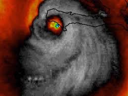
Is it just me? Irma looks to have wobbled North and is now running on the North side of the prediction cone the last hour.
|
chase 22
Weather Hobbyist

Reged:
Posts: 83
Loc: Lubbock, TX/St Pete, FL
|
|
I'm also not seeing how the blocking features will create such a sharp turn to the north like the models are plotting...that is unless Irma slows way down. I just can't see how 175 mph hurricane travelling WNW @ 16 mph will just turn to the north like that.
--------------------
Matt
|
Corkhill1
Verified CFHC User
Reged:
Posts: 10
Loc: Costa Rica
|
|
Hats off to a great website giving us accurate information and helping us to prepare.
It’s going to take a miracle to move it off shore but I’ll take it.
|
Bloodstar
Moderator

Reged:
Posts: 467
Loc: Tucson, AZ
|
|
Quote:
This system is so powerful that it virtually controls the environment surrounding it. My fear is that the statistical models may not be able to factor the potential for Irma to literally over power the customary blocking features to the west and north. That being the case a more westerly point before the turn is still logical and not out of the questionp
Totally agree, I also worry that the storm will also do a better job holding together against shear.
I do think the is trying to handle that, it is pushing the trough retrograde as Irma pushes in. It's also interesting to see the jet "streak" developing in apparent response to Irma (I put streak in quotes because it's not really that fast, less than 100 KTs).
Irma also seems to be following the PVA that develops over Georgia, which makes sense if there is some upper level divergence near the jet 'streak'.
Both the and 12z take the trough axis from positive to negative and retrograde - which could be what's pulling Irma more west after 84 to 96 hours. Then again, Irma could be what's inducing the trough to go negative, retrograde, and deepen. *Scratches head*
Figures, I don't get to take mesoscale until the spring! LOL
--------------------
M. S. Earth and Atmospheric Sciences, Georgia Tech - May 2020
NOAA MADIS/HADS Programmer
U. Arizona PhD Student
|
OrlandoDan
Weather Master

Reged:
Posts: 456
Loc: Longwood, FL
|
|
Quote:
This system is so powerful that it virtually controls the environment surrounding it. My fear is that the statistical models may not be able to factor the potential for Irma to literally over power the customary blocking features to the west and north. That being the case a more westerly point before the turn is still logical and not out of the questionp
Doug, can you cite some examples of recent history storms where this occurred? Just curious if there is a precedent.
--------------------
Keith (1988), Charley (2004), Frances (2004) , Jeanne (2004), Fay (2008), Mathew (2016), Irma (2017), Dorian (2019)
Personal Weather Station: https://www.wunderground.com/dashboard/pws/KFLLONGW67
|
scottsvb
Weather Master
Reged:
Posts: 1184
Loc: fl
|
|
Not that it matters too much but the 12Z Ukmet is about the same.. maybe not as far west but still has more of a S-N component on days 3-4 to take it up the state... 12Z again shifted west to be closer to the UKMet almost... waiting on GEM still.. but these 3 models aren't what we really go by.. just see them as if a trend might happen. 12Z slightly west but not much.. Euro still waiting. Will note the also went west but that's the last model we only glance at for hurricanes. If the 12Z Euro shows a more west via the and UKmet...then we'll have to see if the keeps slightly going west.. and it's the short term movement that will determine the landfall.. further south it stays thru saturday (and how fast it moves west) before the turn will determine the landfall location in Florida (or off the coast via 6Z and 12Z )
|
Owlguin
Weather Hobbyist
Reged:
Posts: 73
|
|
Seems to be running slightly North of the forecast points. What, if anything, might that mean?
|
Doombot!
Weather Guru

Reged:
Posts: 160
Loc: Lakeland, Fl.
|
|
Quote:
Seems to be running slightly North of the forecast points. What, if anything, might that mean?
Could be a lot of things.
Most likely it's a wobble, but I've also seen storms that parallel PR and Hispaniola move north to "avoid" land friction.
I'd guess there will be a bit of a more of a westerly bend to compensate soon, but if it keeps moving north of the line, that would indicate a weaker Bermuda High and a Florida miss.
Don't count on it, thought. Hurricanes wobble all the time.
|
scottsvb
Weather Master
Reged:
Posts: 1184
Loc: fl
|
|
I don't see it going north of the forecasted pts.. last night it went south of it... question when does it turn more back around 275dg.. tonight? Friday and for how long is the question into saturday before the turn
|
AgentB
Weather Guru

Reged:
Posts: 188
Loc: Winter Park, FL
|
|
12Z Euro pushed it back south and west. Skirts the northern coast of Cuba, through the Middle Keys, landfall around Naples and tracks up the peninsula between Orlando and Tampa.
--------------------
Check the Surf
|
Colleen A.
Moderator

Reged:
Posts: 1432
Loc: Florida
|
|
Quote:
I don't see it going north of the forecasted pts.. last night it went south of it... question when does it turn more back around 275dg.. tonight? Friday and for how long is the question into saturday before the turn
IF it turns...which I'm praying it does, but there's no guarantee it will with the speed at which it's going. We've been through this before. Remember Jeanne?
I sure do. and , too. I'll go with Mike C and Ceil with trusting the models.
--------------------
You know you're a hurricane freak when you wake up in the morning and hit "REFRESH" on CFHC instead of the Snooze Button.
|
MikeC
Admin
Reged:
Posts: 4689
Loc: Orlando, FL
|
|
Quick summary (I don't have much time this afternoon)
12Z slightly west, just offshore, closest to WPB (20-30 miles) midday Sunday. Landfall midday Monday near Savannah, GA.
12Z Euro shifts west, over Marathon Key as Cat 5. Then landfall southwest Florida Sunday morning, then up through the spine, over or just west of Orlando near Lake City, FL Midday Monday. Extremely devastating run.
More detail later
|
scottsvb
Weather Master
Reged:
Posts: 1184
Loc: fl
|
|
Yeah... trending in the models is the key.. went west but only slightly.. HMon and HRWF follow suit when the does things.. but trender further west again..same with GEM and even UKMet is more west into the Keys. This is looking like it will hit florida (80%) or at least skiming the east coast of FL with hurricane force winds... this is on the eastern outliner models.. or if it goes with the GEM/UKMet, Euro.. even Tampa will get TS winds and maybe Hurricane force winds .. especially in Naples,Ft Myers area.
|
cieldumort
Moderator

Reged:
Posts: 2522
Loc: Austin, Tx
|
|
Experimental IBM Deep Thunder model now progging a worst case scenario for Miami, S Florida.
906mb Cat 5 landfall near Key Largo at 04z Sunday Sep 10. Surge alone would demolish much of the region. Winds would likely exceed ability for even the most well-built buildings, high rises, condos to withstand having windows blown out, structural damage. Cranes would likely sway into buildings, or crash into and on them. Etc.
*EXPERIMENTAL MODEL. AS AS WITH ALL MODELS, USE WITH EXTREME CAUTION!*

Image cr: Dan Leonard, Senior meteorologist at the Weather Company.
|
Colleen A.
Moderator

Reged:
Posts: 1432
Loc: Florida
|
|
Quote:
Yeah... trending in the models is the key.. went west but only slightly.. HMon and HRWF follow suit when the does things.. but trender further west again..same with GEM and even UKMet is more west into the Keys. This is looking like it will hit florida (80%) or at least skiming the east coast of FL with hurricane force winds... this is on the eastern outliner models.. or if it goes with the GEM/UKMet, Euro.. even Tampa will get TS winds and maybe Hurricane force winds .. especially in Naples,Ft Myers area.
I just watched Governor Scott give an update. It doesn't sound great for where I live; we could get 100mph winds (not sustained, of course). I've never been a fear monger and I'm not going to start being one now. Just being cautious. I'm really tired of this storm, to be honest. 
--------------------
You know you're a hurricane freak when you wake up in the morning and hit "REFRESH" on CFHC instead of the Snooze Button.
|
Bloodstar
Moderator

Reged:
Posts: 467
Loc: Tucson, AZ
|
|
Quote:
Quote:
Yeah... trending in the models is the key.. went west but only slightly.. HMon and HRWF follow suit when the does things.. but trender further west again..same with GEM and even UKMet is more west into the Keys. This is looking like it will hit florida (80%) or at least skiming the east coast of FL with hurricane force winds... this is on the eastern outliner models.. or if it goes with the GEM/UKMet, Euro.. even Tampa will get TS winds and maybe Hurricane force winds .. especially in Naples,Ft Myers area.
I just watched Governor Scott give an update. It doesn't sound great for where I live; we could get 100mph winds (not sustained, of course). I've never been a fear monger and I'm not going to start being one now. Just being cautious. I'm really tired of this storm, to be honest. 
I probably shouldn't mention that Jose does a loop in some of the latest runs... J storms and loops LOL (Off topic I know, but gotta find an excuse to smile and not cry)

--------------------
M. S. Earth and Atmospheric Sciences, Georgia Tech - May 2020
NOAA MADIS/HADS Programmer
U. Arizona PhD Student
|
IsoFlame
Weather Analyst

Reged:
Posts: 382
Loc: One block off the Atlantic Oce...
|
|
Quote:
"I'm also not seeing how the blocking features will create such a sharp turn to the north like the models are plotting...that is unless Irma slows way down. I just can't see how 175 mph hurricane travelling WNW @ 16 mph will just turn to the north like that. "
-Matt
Agree. Given the historic intensity of this hurricane, the westward "inertia" in track since becoming a major a week ago, and the latitude of the weather features that are forecast to exert increasing influence in 48-72hr, the "turn" may be more of a "bend".
--------------------
CoCoRaHS Weather Observer (FL-VL-42) & Surf Forecaster: https://www.surf-station.com/north-florida-surf-forecast-3/
Edited by IsoFlame (Thu Sep 07 2017 04:19 PM)
|
Lamar-Plant City
Storm Tracker

Reged:
Posts: 392
Loc: Plant City, Florida
|
|
Quote:
Given the historic intensity of this hurricane, the westward "inertia" in track since becoming a major a week ago, and the latitude of the weather features that are forecast to exert increasing influence in 48-72hr , totally concur. The "turn" may be more of a "bend".
Yeah...we are on the left portion of the cone but I am sensing (and seeing) models trending back towards me. My house is up and flood-safe and I have pretty solid home-made shutters that can go up quickly. But my 80 year old mom is in eastern Polk country (right under the paths of Charlie, AND Jeanne) and with dad gone I will have to keep an eye out for her and the property as well.....THE TURN is what it is all about now...a little longer or less and we are dead center! Resting up today as the next 3 may be busy!
--------------------
If you don't like the weather, wait 5 minutes...
2023 Season Prediction: 17/6/2
|
cieldumort
Moderator

Reged:
Posts: 2522
Loc: Austin, Tx
|
|
GFS has been showing a distinct poleward bias vs . w/ the verifying much better. Almost spot-on.

Mapping cr. Brian Tang, Department of Atmospheric and Environmental Sciences University at Albany.
H/t Philippe Papin
|
Colleen A.
Moderator

Reged:
Posts: 1432
Loc: Florida
|
|
Quote:
Quote:
Quote:
Yeah... trending in the models is the key.. went west but only slightly.. HMon and HRWF follow suit when the does things.. but trender further west again..same with GEM and even UKMet is more west into the Keys. This is looking like it will hit florida (80%) or at least skiming the east coast of FL with hurricane force winds... this is on the eastern outliner models.. or if it goes with the GEM/UKMet, Euro.. even Tampa will get TS winds and maybe Hurricane force winds .. especially in Naples,Ft Myers area.
I just watched Governor Scott give an update. It doesn't sound great for where I live; we could get 100mph winds (not sustained, of course). I've never been a fear monger and I'm not going to start being one now. Just being cautious. I'm really tired of this storm, to be honest. 
I probably shouldn't mention that Jose does a loop in some of the latest runs... J storms and loops LOL (Off topic I know, but gotta find an excuse to smile and not cry)

I hear you. ;-) I'm doing laundry like I work at a laundromat and cleaning like a maniac. Including the fridge. Stay safe. Tampa is backed up on all roads.
--------------------
You know you're a hurricane freak when you wake up in the morning and hit "REFRESH" on CFHC instead of the Snooze Button.
|


 Threaded

 [Re:
[Re: 


