MikeC
Admin
Reged:
Posts: 4635
Loc: Orlando, FL
|
|
1PM Update 7 Aug 2018
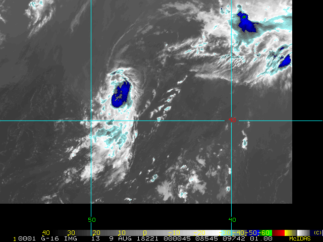
Invest 97L has become Sub-Tropical Storm Debby out in the north-central Atlantic. Debby is is expected to be short-lived and unlikely to affect land as a named cyclone.
-Ciel
9AM update 4 August 2018
Hurricane Hector is likely to stay south of the Hawaiian islands, but is close enough to feel some effects from rough surf, it should be monitored over the next week.
Invest 97L is out in the central Atlantic but likely to not affect land, it has a 20% chance for development.

Original Update
August has started and the Atlantic basin is quiet, which is fairly usual for the start of August, things typically don't get going until mid to late August, and that seems to be the case this year.
However, in the Pacific, Hurricane Hector has increased to 110mph winds tonight, and the official forecast is starting to close in near Hawaii. Flhurricane normally does not discuss systems outside of the Atlantic since we don't have as many tools available, but we do make exceptions for any Hawaii threats.
The Current 5 day forecast keeps Hector as a Major Category 3 hurricane southeast of the Big Island, and some models project it may get closer mid to late next week (See the forecast lounge for details on that) However, some of the models keep it south of Hawaii, so it's in the monitoring state right now, but with a few of the models taking it over or near Hawaii it's time to start watching it. Odds are it stays south of Hawaii, however.
This will likely change some as the days progress, but it is important to watch into next week. If it approaches Hawaii next week, it will likely weakening (slowly) as it approaches, however. the threat to the Big Island is irritated by the active lava flows in the Puna region, and the non-native extremely tall and brittle Albizia trees are very susceptible to being blown over in even moderate Tropical Storm force winds.

We'll be monitoring it and update if the threat increases or not, since the timeframe for landfall (if it were to occur) would be mid to late next week, there are no cones showing approach. By this weekend there may be a better idea of it, and much more of one early next week. Those in the Big Island, and Maui should keep tabs of the system.
Edited by cieldumort (Tue Aug 07 2018 02:47 PM)
|
cieldumort
Moderator

Reged:
Posts: 2497
Loc: Austin, Tx
|
|
Probably just about Cat 5 for a while now. Also, rather annular.
Eye Shape & Diameter: Circular with a diameter of 16 nautical miles (18 statute miles)
H. Estimated (by SFMR or visually) Maximum Surface Wind Inbound: 137kts (157.7mph)
I. Location & Time of the Estimated Maximum Surface Wind Inbound: 9 nautical miles to the NNW (329°) of center fix at 17:36:00Z
J. Maximum Flight Level Wind Inbound: From 52° at 146kts (From the NE at 168.0mph)
K. Location & Time of the Maximum Flight Level Wind Inbound: 10 nautical miles (12 statute miles) to the NNW (327°) of center fix at 17:35:30Z
L. Estimated (by SFMR or visually) Maximum Surface Wind Outbound: 101kts (116.2mph)
M. Location & Time of the Estimated Maximum Surface Wind Outbound: 10 nautical miles (12 statute miles) to the SE (137°) of center fix at 17:42:00Z
N. Maximum Flight Level Wind Outbound: From 240° at 123kts (From the WSW at 141.5mph)
O. Location & Time of the Maximum Flight Level Wind Outbound: 7 nautical miles to the SE (144°) of center fix at 17:41:00Z
P. Maximum Flight Level Temp & Pressure Altitude Outside Eye: 8°C (46°F) at a pressure alt. of 3,044m (9,987ft)
Q. Maximum Flight Level Temp & Pressure Altitude Inside Eye: 19°C (66°F) at a pressure alt. of 3,038m (9,967ft)
R. Dewpoint Temp (collected at same location as temp inside eye): 9°C (48°F)
R. Sea Surface Temp (collected at same location as temp inside eye): Not Available
S. Fix Determined By: Penetration, Radar, Wind, Pressure and Temperature
S. Fix Level: 700mb
T. Navigational Fix Accuracy: 0.02 nautical miles
T. Meteorological Accuracy: 0.5 nautical miles
Remarks Section:
Maximum Flight Level Wind: 146kts (~ 168.0mph) which was observed 10 nautical miles (12 statute miles) to the NNW (327°) from the flight level center at 17:35:30Z
|
|


 Threaded


