cieldumort
Moderator

Reged:
Posts: 2519
Loc: Austin, Tx
|
|
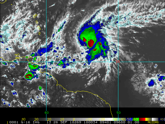
4AM ET Update 26 September 2018
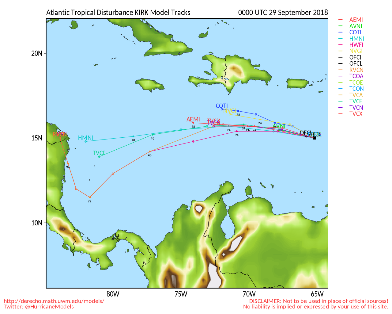
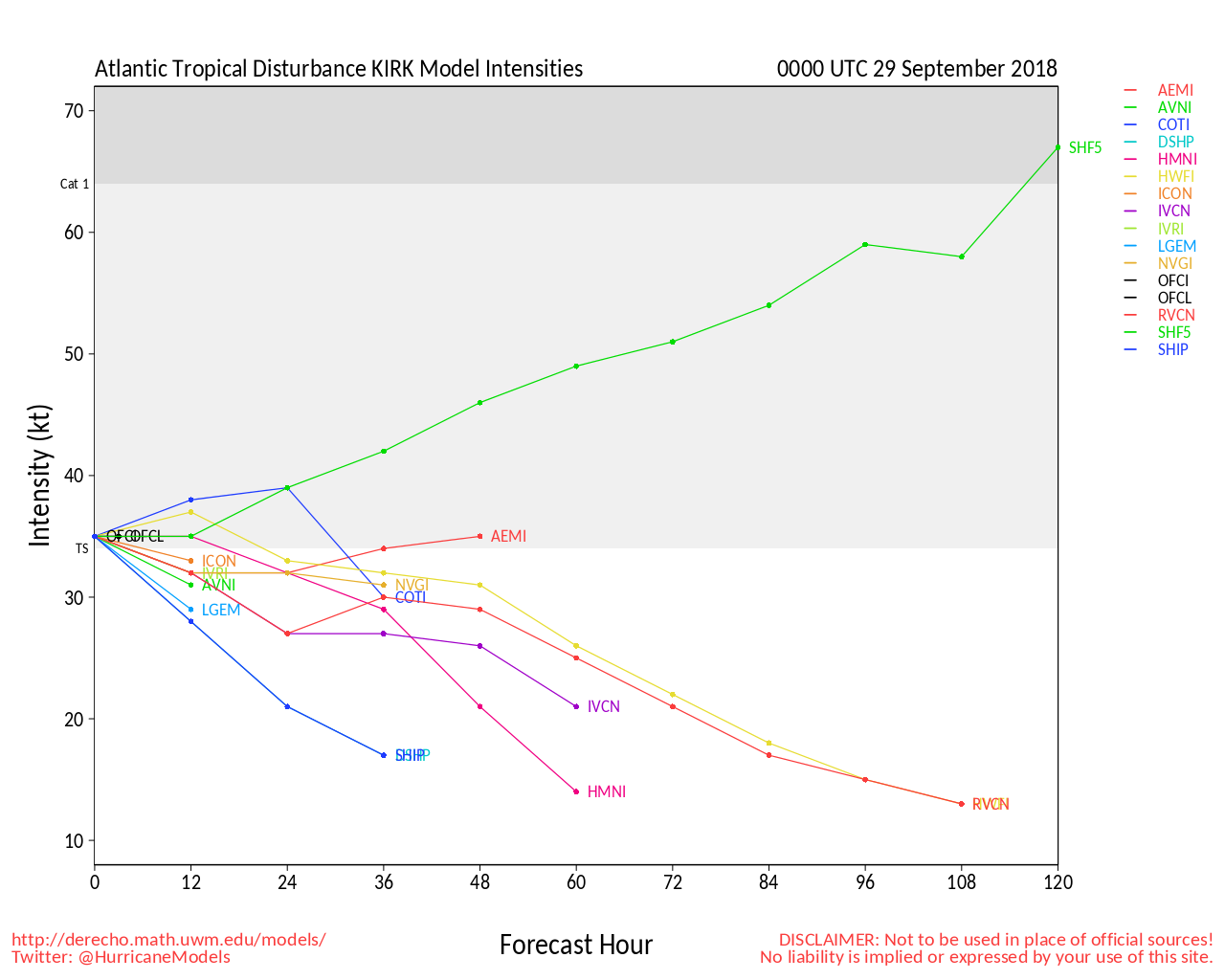
Kirk underwent tropical cyclone regeneration over the past 24 hours and Advisories are resuming. As winds are already blowing at or above 40 MPH and the storm is now also much closer to the Lesser Antilles, this includes Tropical Storm Watches and Warnings.
Elsewhere, Leslie is undergoing a rapid merging and regeneration. As enough of her core has remained intact, the cyclone is expected to keep the same name, and advisories are likely to resume as soon as later today. Leslie may become a very powerful tropical and/or hybrid cyclone and stay with us for quite a while, possibly racking up sizeable ACE points for the 2018 Atlantic Hurricane Season, but fortunately doing so well away from most land.
Invest 98L is passing by the Carolinas, adding to the influx of moisture in the region and reigniting flooding woes. The weak Low now has only a modest chance of becoming classified, and is likely to zip out to sea by Friday, either way.
4PM ET Update 22 September 2018
A tropical cornucopia of systems are now filling the screens as we close out the end of an already very active September.
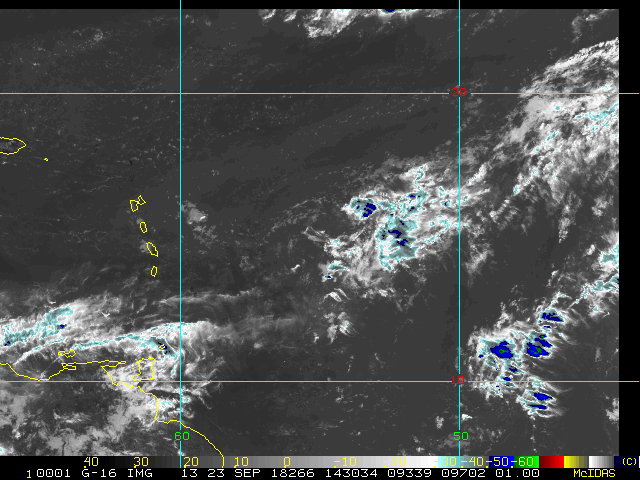
With this update we now have two new Tropical Cyclones: TD ELEVEN, located about 450 miles east of the Windward Islands, and also Tropical Storm Kirk, located in the far eastern Atlantic.
There are another six Areas of Interest coming up, two of which may become subtropical or tropical cyclones by the early part of next week (98L between Bermuda and the Carolinas, plus also the large, non-tropical Low in the central Atlantic).
Despite forecasts for a near-to-below-average year, September seems to have made other plans. We now already have had six named storms this month. The record for named storms in any one month in the Atlantic going back though known history is eight, which has occurred five times: Oct 1950, Sep 2002, Aug 2004, Sep 2010, and most recently Aug 2012. Two more names this month would tie that record, three would break it.
Original Entry

The Atlantic Hurricane Season officially runs through the end of November and we have several reminders of that today. Indications are strong that the last ten days of this month will likely not go out quietly, with several lows and a couple African Easterly Waves already on the radar.
Two of these features in particular have already been Invest tagged, 97L and 98L. Of these two, 98L appears to be organizing rapidly today, with maximum sustained winds already to tropical storm force approaching the island nation of Bermuda. This system is especially interesting, as it looks to have been spawned in part from an infusion of energy from x-Florence.
Main page mapping and links will be coming soon. Meanwhile, you can also track model outputs and more with us in the Forecast Lounge:
99L (Now Tropical Storm Kirk) Forecast Lounge
98L Forecast Lounge
97L (Now TD ELEVEN) Forecast Lounge
Edited by cieldumort (Wed Sep 26 2018 04:45 AM)
|
cieldumort
Moderator
Reged:
Posts: 2519
Loc: Austin, Tx
|
|
|
danielw
Moderator

Reged:
Posts: 3527
Loc: Hattiesburg,MS (31.3N 89.3W)
|
|
TROPICAL STORM KIRK FORECAST/ADVISORY NUMBER 10
NWS National Hurricane Center MIAMI FL AL122018
0900 UTC WED SEP 26 2018
WATCHES AND WARNINGS
--------------------
CHANGES IN WATCHES AND WARNINGS WITH THIS ADVISORY...
THE GOVERNMENT OF BARBADOS HAS ISSUED A TROPICAL STORM WARNING FOR
BARBADOS. THE GOVERNMENT OF ST. LUCIA HAS ISSUED A TROPICAL STORM
WARNING FOR ST. LUCIA.
THE GOVERNMENT OF BARBADOS HAS ISSUED A TROPICAL STORM WATCH FOR
ST. VINCENT AND THE GRENADINES.
SUMMARY OF WATCHES AND WARNINGS IN EFFECT...
A TROPICAL STORM WARNING IS IN EFFECT FOR...
* BARBADOS
* ST. LUCIA
A TROPICAL STORM WATCH IS IN EFFECT FOR...
* ST. VINCENT AND THE GRENADINES
A TROPICAL STORM WARNING MEANS THAT TROPICAL STORM CONDITIONS ARE
EXPECTED SOMEWHERE WITHIN THE WARNING AREA WITHIN 36 HOURS.
A TROPICAL STORM WATCH MEANS THAT TROPICAL STORM CONDITIONS ARE
POSSIBLE WITHIN THE WATCH AREA... IN THIS CASE WITHIN 36 HOURS.
INTERESTS ELSEWHERE IN THE LEEWARD ISLANDS SHOULD MONITOR THE
PROGRESS OF KIRK AS ADDITIONAL WARNINGS OR WATCHES COULD BE ISSUED
LATER TODAY.
TROPICAL STORM CENTER LOCATED NEAR 11.8N 52.7W AT 26/0900Z
POSITION ACCURATE WITHIN 25 NM
PRESENT MOVEMENT TOWARD THE WEST OR 280 DEGREES AT 16 KT
ESTIMATED MINIMUM CENTRAL PRESSURE 1004 MB
MAX SUSTAINED WINDS 40 KT WITH GUSTS TO 50 KT.
34 KT.......100NE 90SE 0SW 40NW.
12 FT SEAS..150NE 120SE 0SW 120NW.
WINDS AND SEAS VARY GREATLY IN EACH QUADRANT. RADII IN NAUTICAL
MILES ARE THE LARGEST RADII EXPECTED ANYWHERE IN THAT QUADRANT.
|
MikeC
Admin
Reged:
Posts: 4673
Loc: Orlando, FL
|
|
Florence flooding still occurring see https://flhurricane.com/imageanimator.php?401
|
danielw
Moderator
Reged:
Posts: 3527
Loc: Hattiesburg,MS (31.3N 89.3W)
|
|
Tropical Storm Kirk at Noon EDT, Wednesday.

Edited by danielw (Wed Sep 26 2018 12:04 PM)
|
cieldumort
Moderator
Reged:
Posts: 2519
Loc: Austin, Tx
|
|
(Kirk)
Several clean SFMR and flight-level results support 65 MPH - and still intensifying.
Tracking NW or maybe even NNW, at least at this time.
|
cieldumort
Moderator
Reged:
Posts: 2519
Loc: Austin, Tx
|
|
The 2PM Intermediate Advisory set Kirk's winds at a possibly conservative 60 MPH. This cyclone is undergoing a healthy rate of deepening today, going from an estimated1004mb while the plane was approaching, to 998mb during the last pass though the center.
Microwave passes show clear evidence of an incipient eye, not yet apparent in conventional satellite.
The last pass though Kirk's center also supports potential for an eye to form today, with a very impressive warm core already in place.
Quote:
Product: Air Force Vortex Message (URNT12 KNHC)
Transmitted: 26th day of the month at 17:41Z
Agency: United States Air Force
Aircraft: Lockheed WC-130J Hercules with reg. number AF97-5305
Storm Number & Year: 12 in 2018
Storm Name: Kirk (flight in the North Atlantic basin)
Mission Number: 1
Observation Number: 20
A. Time of Center Fix: 26th day of the month at 17:23:00Z
B. Center Fix Coordinates: 12.53N 54.79W
B. Center Fix Location: 327 statute miles (526 km) to the E (97°) from Bridgetown, Barbados.
C. Minimum Height at Standard Level: 1,425m (4,675ft) at 850mb
D. Minimum Sea Level Pressure: 999mb (29.50 inHg)
E. Dropsonde Surface Wind at Center: From 205° at 9kts (From the SSW at 10mph)
F. Eye Character: Not Available
G. Eye Shape: Not Available
H. Estimated (by SFMR or visually) Maximum Surface Wind Inbound: 42kts (48.3mph)
I. Location & Time of the Estimated Maximum Surface Wind Inbound: 78 nautical miles (90 statute miles) to the SE (127°) of center fix at 16:59:30Z
J. Maximum Flight Level Wind Inbound: From 161° at 53kts (From the SSE at 61.0mph)
K. Location & Time of the Maximum Flight Level Wind Inbound: 98 nautical miles (113 statute miles) to the SE (130°) of center fix at 16:54:00Z
L. Estimated (by SFMR or visually) Maximum Surface Wind Outbound: 51kts (58.7mph)
M. Location & Time of the Estimated Maximum Surface Wind Outbound: 19 nautical miles (22 statute miles) to the N (355°) of center fix at 17:29:30Z
N. Maximum Flight Level Wind Outbound: From 108° at 61kts (From the ESE at 70.2mph)
O. Location & Time of the Maximum Flight Level Wind Outbound: 36 nautical miles (41 statute miles) to the N (358°) of center fix at 17:34:30Z
P. Maximum Flight Level Temp & Pressure Altitude Outside Eye: 16°C (61°F) at a pressure alt. of 1,521m (4,990ft)
Q. Maximum Flight Level Temp & Pressure Altitude Inside Eye: 24°C (75°F) at a pressure alt. of 1,537m (5,043ft)
R. Dewpoint Temp & Sea Surface Temp: Not Available
S. Fix Determined By: Penetration, Wind, Pressure and Temperature
S. Fix Levels (surface & flight level centers within 5nm of each other): Surface and 850mb
T. Navigational Fix Accuracy: 0.02 nautical miles
T. Meteorological Accuracy: 3 nautical miles
Remarks Section:
Maximum Flight Level Wind: 61kts (~ 70.2mph) which was observed 47 nautical miles (54 statute miles) to the E (82°) from the flight level center at 17:34:30Z
|
|


 Threaded


