cieldumort
Moderator

Reged:
Posts: 2664
Loc: Austin, Tx
|
|
2:00PM EDT Update 18 October 2019
SIXTEEN has become Tropical Storm Nestor. Nestor is a hybridish tropical storm, but tropical enough to qualify. More importantly, the impacts from this cyclone are going to be much more in line with that of a strong tropical storm - and perhaps yet still a hurricane - than garden variety subtropical storms, although very lopsided, with most of the worst weather on the eastern side, for now.
10:00 AM EDT Update 17 October 2019
96L is expected to become a named storm later today or tonight, and advisories have been issued for what is now PTC SIXTEEN.
A Tropical Storm Warning is in effect from the Mississippi/Alabama border to the Ochlockonee River, Florida.
A Tropical Storm Warning is in effect from Grand Isle, Louisiana to the Mouth of the Pearl River.
A Tropical Storm Watch is in effect east of the Ochlockonee River to Yankeetown, Florida.
A Storm Surge Watch is in effect from Indian Pass, Florida, to Clearwater, Florida.
Original Update

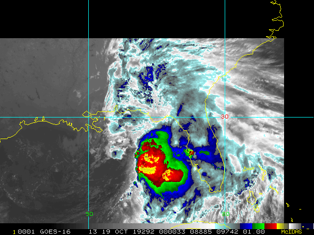
Conditions for subtropical and tropical cyclone development closer to home are on the rise climatologically in mid to late October, and right on cue we have a concerning trof in the southwestern Gulf, having split off from the same parent Central American feature that went on to also spin out PTC SEVENTEEN in the eastern Pacific yesterday.
Now over the very warm waters of the Bay of Campeche, 96L is showing signs of pulling things together at a somewhat faster clip, and as of this post, gives it a coin toss of becoming a subtropical or tropical cyclone within just the next 48 hours.
Nestor Forecast Lounge: Nestor
Edited by cieldumort (Fri Oct 18 2019 02:07 PM)
|
cieldumort
Moderator
Reged:
Posts: 2664
Loc: Austin, Tx
|
|
SIXTEEN appears this morning to be fairly well defined - with characteristics in many ways more like a sheared and a bit sloppy, tropical cyclone, rather than a sub-tropical one - A combination of recon/ships/buoys/scatterometer data suggesting that pressures are falling and winds are on the increase as well. Could now be 1002mb/45mph, nameable, or very nearly so.
|
cieldumort
Moderator
Reged:
Posts: 2664
Loc: Austin, Tx
|
|
Most recent recon fix finds Nestor rather hybrid. There is still time for the cyclone to become more fully tropical, and perhaps yet a hurricane, but time (water, mostly) is running out. Regardless, this is a powerful storm and people in its sphere of influence should take all watches and warnings seriously. The strongest winds, heaviest rains and potential for tornadoes remains well removed from the center, which are not reflected in this Vort. Quote:
Product: Air Force Vortex Message (URNT12 KNHC)
Transmitted: 18th day of the month at 19:46Z
Agency: United States Air Force
Aircraft: Lockheed WC-130J Hercules with reg. number AF96-5301
Tropical Depression: Sixteen (flight in the North Atlantic basin)
Mission Number: 2
Observation Number: 13
A. Time of Center Fix: 18th day of the month at 19:35:40Z
B. Center Fix Coordinates: 26.67N 89.32W
B. Center Fix Location: 233 statute miles (375 km) to the S (169°) from New Orleans, LA, USA.
C. Minimum Height at Standard Level: Not Available
D. Minimum Sea Level Pressure: 999mb (29.50 inHg) - Extrapolated
E. Dropsonde Surface Wind at Center (Undecoded): NA
F. Eye Character: Not Available
G. Eye Shape: Not Available
H. Estimated (by SFMR or visually) Maximum Surface Wind Inbound: 23kts (26.5mph)
I. Location & Time of the Estimated Maximum Surface Wind Inbound: 29 nautical miles (33 statute miles) to the ESE (119°) of center fix at 19:24:30Z
J. Maximum Flight Level Wind Inbound: From 234° at 25kts (From the SW at 28.8mph)
K. Location & Time of the Maximum Flight Level Wind Inbound: 30 nautical miles (35 statute miles) to the ESE (114°) of center fix at 19:23:00Z
L. Estimated (by SFMR or visually) Maximum Surface Wind Outbound: 13kts (15.0mph)
M. Location & Time of the Estimated Maximum Surface Wind Outbound: 17 nautical miles (20 statute miles) to the WNW (302°) of center fix at 19:41:30Z
N. Maximum Flight Level Wind Outbound: From 31° at 15kts (From the NNE at 17.3mph)
O. Location & Time of the Maximum Flight Level Wind Outbound: 17 nautical miles (20 statute miles) to the WNW (302°) of center fix at 19:41:30Z
P. Maximum Flight Level Temp & Pressure Altitude Outside Eye: 24°C (75°F) at a pressure alt. of 398m (1,306ft)
Q. Maximum Flight Level Temp & Pressure Altitude Inside Eye: 24°C (75°F) at a pressure alt. of 398m (1,306ft)
R. Dewpoint Temp (collected at same location as temp inside eye): 22°C (72°F)
R. Sea Surface Temp (collected at same location as temp inside eye): Not Available
S. Fix Determined By: Penetration, Wind and Pressure
S. Fix Level: 1,500 feet
T. Navigational Fix Accuracy: 0.02 nautical miles
T. Meteorological Accuracy: 2 nautical miles
|
Prospero
Storm Tracker

Reged:
Posts: 269
Loc: Gulfport, FL
|
|
Here in Gulfport, FL, we've had 4 inches of rain and gusts to 44 mph in the last hour.
This may be the storm of the season for us. No complaints...
--------------------
Gulfport Florida Webcam - Gulfport Florida Weather Station - Clearwater Beach Cams
|
|


 Threaded


