Current Radar or Satellite Image

Flhurricane.com - Central Florida Hurricane Center - Tracking Storms since 199530 Years of Hurricanes Without the Hype - Since 1995


Days since last H. Landfall - US: Any 103 (Milton) , Major: 103 (Milton) Florida - Any: 103 (Milton) Major: 103 (Milton)


Archives 2020s >> 2020 News Talkbacks

Pages: 1
MikeCAdministrator
Admin


Reged:
Posts: 4635
Loc: Orlando, FL
Late July Activity
      #100999 - Tue Jul 21 2020 11:26 AM

7:00AM CDT Update 25 July 2020
Hanna found to be a hurricane by recon this morning, landfall likely between Corpus Cristi and Brownsville.

Gonzalo still remains very weak.

92L is up to a 60% chance to develop over the next 5 days.]

In Hawaii, Douglas has raised Hurricane watches for the Big Island, Maui, and Oahu.

10:00PM CDT Update 24 July 2020
Tropical Storm Hanna has strengthened to a 65mph Tropical storm tonight, it's likely to become a hurricane sometime tomorrow morning. Although the NHC forecasts a 75 mph hurricane, they note that the peak intensity could be higher than what is
shown since landfall is expected to occur between the 12 and 24 hour forecast times.

Because of this and the slight shift south in position, the Hurricane Warning has been extended southward to Port Mansfield Texas. The Tropical Storm Warning has been extended northward to High Island Texas. The government of Mexico has issued a Tropical Storm Warning north of Barra el Mezquital to the Mouth of Rio Grande.

Those in Texas should prepare for a potent hurricane with serious flooding risks as best they can since this increased more rapidly that originally forecast. Pay attention to local media and officials for the best information for your particular area.
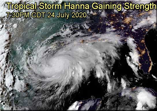


9:00PM CDT Update 24 July 2020
Hanna may be close to becoming a hurricane tonight. Important updates are likely coming soon from NHC. The prospect that Hanna comes in significantly stronger than forecast is now a distinct possibility. One can also follow along with additional information and model talk in the Hanna Forecast Lounge
Ciel

4:30PM CDT Update 24 July 2020
Hanna is now forecast to be a Hurricane at landfall, and Hurricane and Storm Surge Warnings have been issued for portions of the south Texas Coast. With the core appearing better on radar. If you are in the warning area, please be mindful of local media and officials.

A Hurricane Warning has been issued from Baffin Bay northward to Mesquite Bay, Texas.

A Storm Surge Warning has been issued from Baffin Bay to Sargent, Texas, including Corpus Christi Bay, Copano Bay, Aransas Bay, San Antonio Bay and Matagorda Bay.

11AM Update 22 July 2020
SEVEN is rapidly organizing and has become the earliest seventh named storm in the Atlantic on record, besting even 2005's Gert by two days. Gonzalo is a small, compact and well organized system, and as such, may continue to intensify counter to the global models, which all but missed this cyclone entirely. In fact, NHC now calls for further strengthening and for the cyclone to become a hurricane prior to reaching the Windward Islands.

Elsewhere, recon will be flying Invest 91L in the Gulf of Mexico today, which should help with its forecast. As it stands, the disturbance has about even odds of becoming a named storm prior to impacting the western Gulf. Interests especially from Louisiana to Texas may want to pay close attention to this one, as it could be a prolific rain/flood maker.

Ciel

5PM Update 21 July 2020
Invest 99L is now Tropical Depression Seven, it is forecast to remain below hurricane strength, however it's small size means it could rapidly strengthen or weaken over the next few days, so those in the Windwards should keep watch on it.

91L remains in the Gulf, and has a better shot on Thursday to develop, but still remains relatively low. Another wave east of TD#7 will be the next thing to watch, and also a very small area north of Puerto Rico.

Original Update
The system east of the Windward islands of the Caribbean (99L) is now up to an 80% chance for development, and is very likely to become a storm or depression later today. Conditions become much less favorable this weekend, but in the meantime those in the Eastern Caribbean should keep watch. The next name on the list is Gonzalo.

The system has a relatively small size, and that seems to be working in its favor. Dry air nearby would likely weaken it otherwise. Shear later may be what weakens it this weekend, and the small size works against it there.

The other area near Cuba (91L) still has a 40% chance for development and is not currently being tracked as an Invest.

Recon was tentatively scheduled to check the area out later today, but was since cancelled. Those in the northwest gulf should keep watch on this one, as we could have two active tropical systems later this week.

Conditions aren't great for the Cuba system right now, but it is likely that this improves around Thursday.


Forecast Lounge and Model Talk on Tropical Storm Gonzalo


Forecast Lounge and Model Talk on Hanna in the Gulf of Mexico

Galveston Live Beach Cam
Flhurricane recordings of landfall area radar and webcams


Douglas/Hawaii Approach info


Post Extras: Print Post   Remind Me!   Notify Moderator  
MikeCAdministrator
Admin


Reged:
Posts: 4635
Loc: Orlando, FL
Re: Late July Activity [Re: MikeC]
      #101001 - Tue Jul 21 2020 02:41 PM

The system near cuba (now in eastern GUlf) is now being tracked as 91L.

The other system east of the Caribbean, 99L is now at 90% chance and very likely to begin advisories at 5PM.


Post Extras: Print Post   Remind Me!   Notify Moderator  
bob3d
Weather Hobbyist


Reged:
Posts: 59
Loc: Pasco County, Florida
Re: Late July Activity [Re: MikeC]
      #101004 - Wed Jul 22 2020 12:25 PM

OK. We now have TS Gonzalo headed West. My question is "What happened to Faye?"

--------------------
bob
Time in West Central Florida: 51 years


Post Extras: Print Post   Remind Me!   Notify Moderator  
MikeCAdministrator
Admin


Reged:
Posts: 4635
Loc: Orlando, FL
Re: Late July Activity [Re: MikeC]
      #101006 - Thu Jul 23 2020 01:13 PM

sorry for the extended downtime last night/this morning. This server is pretty old (If you are seeing TLS warnings it's because it's on Centos 5) and the hard drive bit it, it has since been replaced at the NOC. We'll be moving to a new server entirely over the next few months.

This should also solve the stuttering the site has had over the last few months.


Post Extras: Print Post   Remind Me!   Notify Moderator  
Psyber
Storm Tracker


Reged:
Posts: 237
Loc: Ontario, Canada
Re: Late July Activity [Re: MikeC]
      #101009 - Thu Jul 23 2020 11:41 PM

Thank god! I cannot say that I was not seriously concerned when last night was my first check-in and it was shooting MIA errors.

On top of that, if the N and S parts of Hanna organize a bit more, they have 1+ days to strengthen. Maybe not a real flooder but maybe some more wind damage.

--------------------
The safest way to deal with a potential Hurricane hitting you...is to leave and just not be there at all.


Post Extras: Print Post   Remind Me!   Notify Moderator  
MikeCAdministrator
Admin


Reged:
Posts: 4635
Loc: Orlando, FL
Re: Late July Activity [Re: MikeC]
      #101010 - Fri Jul 24 2020 11:16 AM

There's a 50 knot ship report (~60mph) near hannah right now, so I'm wondering if they may give a special advisory or up it at 1pm

Post Extras: Print Post   Remind Me!   Notify Moderator  
MikeCAdministrator
Admin


Reged:
Posts: 4635
Loc: Orlando, FL
Re: Late July Activity [Re: MikeC]
      #101017 - Fri Jul 24 2020 07:23 PM

Added multiple camera + Radar recordings for Hanna: http://flhurricane.com/cyclone/animationlist.php?year=all&tag=Hanna+%282020%29

Post Extras: Print Post   Remind Me!   Notify Moderator  
Prospero
Storm Tracker


Reged:
Posts: 268
Loc: Gulfport, FL
Re: Late July Activity [Re: MikeC]
      #101019 - Fri Jul 24 2020 07:52 PM

Not much beach left right now at Sea Gull Condos:

Sea Gull Condos at Port Aransas, TX

Will be interesting to watch tomorrow morning.

--------------------
Gulfport Florida Webcam - Gulfport Florida Weather Station - Clearwater Beach Cams


Post Extras: Print Post   Remind Me!   Notify Moderator  
MikeCAdministrator
Admin


Reged:
Posts: 4635
Loc: Orlando, FL
Re: Late July Activity [Re: Prospero]
      #101022 - Fri Jul 24 2020 10:10 PM

First pass of Hanna recon picked up 60mph surface winds and 993mb of pressure, after recon was diverted a bit to help with search and rescue. Another pass coming up.

Post Extras: Print Post   Remind Me!   Notify Moderator  
Pages: 1


Extra information
0 registered and 0 anonymous users are browsing this forum.

Moderator:  

Print Topic

Forum Permissions
      You cannot start new topics
      You cannot reply to topics
      HTML is disabled
      UBBCode is enabled

Rating:
Topic views: 12812

Rate this topic

Jump to

Note: This is NOT an official page. It is run by weather hobbyists and should not be used as a replacement for official sources. 
CFHC's main servers are currently located at
Hostdime.com in Orlando, FL.
Image Server Network thanks to Mike Potts and Amazon Web Services. If you have static file hosting space that allows dns aliasing contact us to help out! Some Maps Provided by:
Great thanks to all who donated and everyone who uses the site as well. Site designed for 800x600+ resolution
When in doubt, take the word of the National Hurricane Center