Current Radar or Satellite Image

Flhurricane.com - Central Florida Hurricane Center - Tracking Storms since 199531 Years of Hurricanes Without the Hype - Since 1995


Nothing on the horizon for Atlantic development at the start of July.
Days since last Hurricane Landfall — US Any: 632 (Milton), US Major: 632 (Milton), FL Any: 632 (Milton), FL Major: 632 (Milton)
FlHurricane Atlantic Tropical Cyclone Tracking 🌀 Since 1995
None
HypeScale:
0.02
0510
Communication
Storm Data
Content
Follow & Connect


Archives 2020s >> 2022 Forecast Lounge

Pages: 1
cieldumort
Moderator


Reged:
Posts: 2705
Loc: Austin, Tx
Invest 90L
      #114090 - Sun May 22 2022 03:35 PM


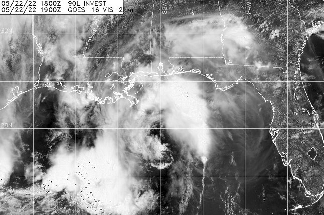
An area of disturbed weather associated with a surface trof and a mesoscale convective vortex interacting with a mid-level low has become better defined today, and is now being tracked as Invest 90L, our first Invest of the 2022 Atlantic Hurricane Season.

While conditions for significant development are not ideal in the sense for a purely tropical cyclone, this preseason, hybridized system would not require much to achieve storm intensity.

More details to come.


Post Extras: Print Post   Remind Me!   Notify Moderator  
Prospero
Storm Tracker


Reged:
Posts: 269
Loc: Gulfport, FL
Re: Invest 90L [Re: cieldumort]
      #114092 - Sun May 22 2022 06:38 PM

Its been something to watch today.

--------------------
Gulfport Florida Webcam - Gulfport Florida Weather Station - Clearwater Beach Cams


Post Extras: Print Post   Remind Me!   Notify Moderator  
Pages: 1


Extra information
0 registered and 22 anonymous users are browsing this forum.

Moderator:  

Print Topic

Forum Permissions
      You cannot start new topics
      You cannot reply to topics
      HTML is disabled
      UBBCode is enabled

Rating:
Topic views: 3896

Rate this topic

Jump to