Ken S.
Registered User
Reged:
Posts: 3
|
|
Is anyone picking up on the long range forecast? Looks like something brewing in the gulf around June 15th.
The feature the was sometimes sniffing out for around the 15th has verified a few days ahead of 's schedule as a weak area of enhanced rotation along a stationary boundary that lies SW-NE from about the Yucatan across central Florida, and has been tagged as Invest 90L. As of morning 6/11/24, has assigned it 20% odds of becoming a tropical cyclone within the next 7 days, but per , only once it has crossed Florida and is offshore of the Southeastern US. The title has been updated accordingly. - Ciel
Edited by cieldumort (Fri Sep 20 2024 02:43 PM)
|
cieldumort
Moderator

Reged:
Posts: 2705
Loc: Austin, Tx
|
|
Central American Gyre is now evident and some other models are coming on board with initiation in the region about that time.
If conditions allow, a spin-off TC would become better organized, but most model members calling for development are also forecasting something of a wet and sloppy, which would be typical this time of year.
We should have a clearer picture by early to mid next week. At present, isn't even outlining a low probability in their 7 day outlook, but it wouldn't surprise to see that change.
|
JMII
Weather Master

Reged:
Posts: 547
Loc: Cape Coral & Margate, FL
|
|
The tagged the gulf area this AM with a 0-20% chance of developement. Looks to bring some much needed rain into FL this week.
--------------------
South FL Native... experienced many tropical systems, put up the panels for:
David 79 - Floyd 87 - Andrew 92 - Georges 98 - Frances 04 - Wilma 05 - Matthew 16 - Irma 17
Lost our St James City rental property to Ian 22
|
MichaelA
Weather Analyst

Reged:
Posts: 956
Loc: Pinellas Park, FL
|
|
Looking at [url= https://earth.nullschool.net/#current/]earth.nullschool.net[/url], the system is rather shallow with the circulation not extending up to 700 mb. Sheer sets in above 700 mb.
--------------------
Michael
PWS
|
cieldumort
Moderator
Reged:
Posts: 2705
Loc: Austin, Tx
|
|
Fairly feisty on final approach along the west coast.
While highly sheared, very lopsided and hybrid, 90L did manage to attain nearly or just barely tropical storm force winds about its core
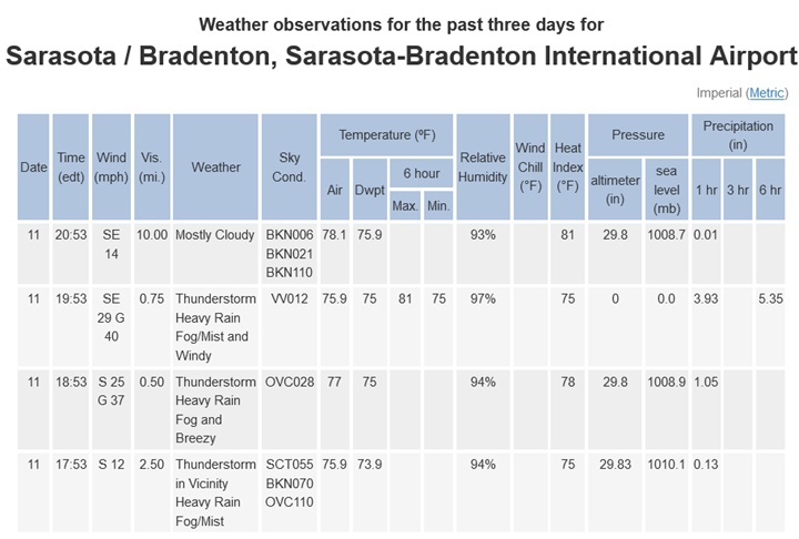
Station 42013 with an anemometer elevation of 3 meters above sea level.
Adjusting up to 10m renders sustained winds of about 32 knots (37 MPH)
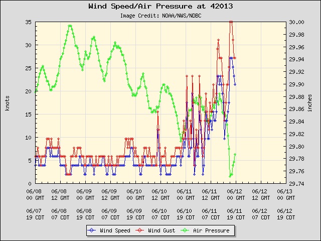
Sarasota–Bradenton International official anemometer with sustained of up to 29 MPH
Some time over the Gulf Stream with less shear may indeed be all the window 90L needs to earn a name for however short a time that may last
|
JMII
Weather Master
Reged:
Posts: 547
Loc: Cape Coral & Margate, FL
|
|
Key West NWS recorded a 51 mph gust.
|
IsoFlame
Weather Analyst

Reged:
Posts: 413
Loc: One block off the Atlantic Oce...
|
|
90L and the plume of moisture streaming up from the SW (aka Yucatan Express) is giving previously parched, wildfire-riddled central Fla a much -needed soaking... maybe a bit too much for the low-lying urban watersheds. I recorded 0.99" yesterday afternoon for the most meaningful rain to date in June. Two friends living a bit south (Oak Hill) and west (Christmas) measured 1/2' during past 36 hours.
--------------------
CoCoRaHS Weather Observer (FL-VL-42) & Surf Forecaster: https://www.surf-station.com/north-florida-surf-forecast-3/
|
JMII
Weather Master
Reged:
Posts: 547
Loc: Cape Coral & Margate, FL
|
|
This system has created a historical level of rainfall for Sarasota:
https://www.wfla.com/weather/sarasota-rainfall-is-nearly-a-1-in-1000-year-event/
8" of rain in just 3 hours 
|


 Threaded


