IsoFlame
Weather Analyst

Reged:
Posts: 413
Loc: One block off the Atlantic Oce...
|
|
Quote:
Debby still has some work to do in order to fend off intrusions of abundant nearby dry air. Having been born from the interaction of a dry gyre and a second tropical disturbance, there are ongoing gaps in her structure needing to be filled. One way the cyclone is attempting to do this is by working on developing an inner core. For now, shear is supportive, and SSTs are more than supportive.
Other than a few isolated thunderstorms scattered along the northern rim, the rest of the Gulf (minus Debby) is remarkably devoid of low-level moisture for early August: GOMEX water vapor loop
Very moist to the east of Debby. A tighter core will be key to compensate for the current lopsided availability given the lack of shear and high- octane SST's.
--------------------
CoCoRaHS Weather Observer (FL-VL-42) & Surf Forecaster: https://www.surf-station.com/north-florida-surf-forecast-3/
|
JMII
Weather Master

Reged:
Posts: 547
Loc: Cape Coral & Margate, FL
|
|
My brother is actually visiting some friends this weekend in Palm Harbor and reports the surge is coming over the docks in the marina. High tide is is an hour away. The wind is only blowing 12-15 there right now. There is a radar indicated tornado embedded in a feeder band working its way thru Zolfo Springs / Wauchula area right now.
|
IsoFlame
Weather Analyst
Reged:
Posts: 413
Loc: One block off the Atlantic Oce...
|
|
Radar @ 3 pm suggests Debby's center has jogged to the NE- about 12 miles closer to Florida's west central coast than the 2pm coordinates: Tampa Bay radar
May be a brief wobble, however I believe it's significant enough that the cone may have to shift back east a bit with the 5pm advisory. Seems to me that lopsided east side an elongated TC's like Debbie re-curve earlier than intitially forecast and landfall further south on the Florida peninsula as they gain latitude in the eastern GOMEX.
Edited by IsoFlame (Sun Aug 04 2024 03:38 PM)
|
Owlguin
Weather Hobbyist
Reged:
Posts: 78
|
|
I’ve noticed that NE jog. we’ll have to see if that continues. The used to provide a center line of the projected path, which made unexpected turns a little easier to monitor, but they apparently got rid of that along with their hurricane model maps.
|
JMII
Weather Master
Reged:
Posts: 547
Loc: Cape Coral & Margate, FL
|
|
Quote:
I’ve noticed that NE jog. we’ll have to see if that continues. The used to provide a center line of the projected path, which made unexpected turns a little easier to monitor, but they apparently got rid of that along with their hurricane model maps.
I use the map at Weather Underground since it shows the path along with a satellite and radar overlay: https://www.wunderground.com/wundermap just wish the radar was hi-def like the Radar Scope app.
If anyone has an app or site that provides the line plus hi-def radar let me know.
Debby is most definitely EAST of the forecast line but the last few radar frames show N movement vs the previous NE direction.
--------------------
South FL Native... experienced many tropical systems, put up the panels for:
David 79 - Floyd 87 - Andrew 92 - Georges 98 - Frances 04 - Wilma 05 - Matthew 16 - Irma 17
Lost our St James City rental property to Ian 22
|
IsoFlame
Weather Analyst
Reged:
Posts: 413
Loc: One block off the Atlantic Oce...
|
|
Very concerned for my 91-yr old dad who lives near the Little Satilla in SE Georgia...
RAINFALL: Debby is expected to produce rainfall totals of 6 to 12 inches, with maximum amounts of 18 inches, across portions of northern Florida and southeastern North Carolina through Friday morning. This rainfall will likely result in areas of considerable flash and urban flooding, with significant river flooding expected.
Across portions of southeast Georgia and South Carolina, 10 to 20 inches of rainfall, with local amounts to 30 inches, are expected through Friday morning. This potentially historic rainfall will likely result in areas of catastrophic flooding.
--------------------
CoCoRaHS Weather Observer (FL-VL-42) & Surf Forecaster: https://www.surf-station.com/north-florida-surf-forecast-3/
|
cieldumort
Moderator

Reged:
Posts: 2705
Loc: Austin, Tx
|
|
Quote:
I use the map at Weather Underground since it shows the path along with a satellite and radar overlay: https://www.wunderground.com/wundermap just wish the radar was hi-def like the Radar Scope app.
If anyone has an app or site that provides the line plus hi-def radar let me know.
Worth mentioning that OSPO Floaters are back up 04L Floater
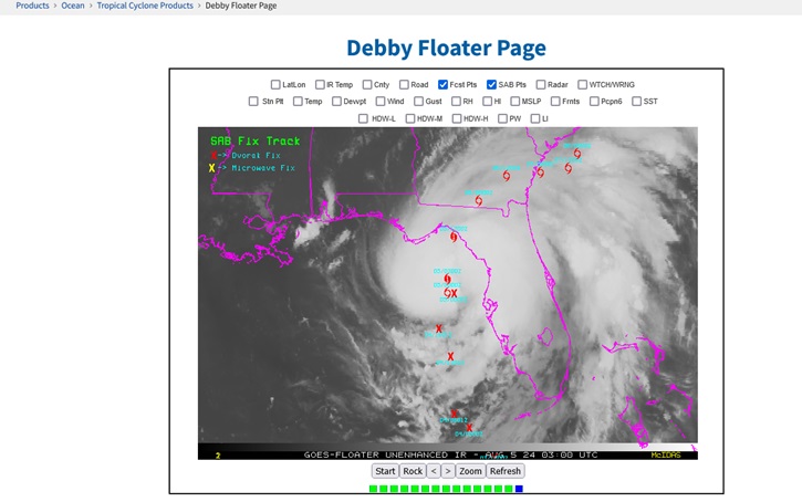
I also use Wunderground myself. MyRadar (upgrade) is another viable app for tracking radar against the center line and cone.
|


 Threaded

 [Re:
[Re: 

