F
Current Radar or Satellite Image

Flhurricane.com - Central Florida Hurricane Center - Tracking Storms since 1995Hurricanes Without the Hype! Since 1995


Modeled CAG/TC with now 60% NHC odds within 7 days. Entire NW Carib & Gulf should monitor for potential hurricane development.
Days since last H. Landfall - US: Any 9 (Francine) , Major: 387 (Idalia) Florida - Any: 46 (Debby) Major: 387 (Idalia)


General Discussion >> 2024 Forecast Lounge

Pages: 1
cieldumort
Moderator


Reged:
Posts: 2409
Loc: Austin, Tx
Hurricane Hone Lounge
      #115090 - Wed Aug 21 2024 06:19 PM


Left: Invest 91E. Right: Hurricane Gilma

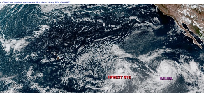
A well-defined low pressure area east-southeast of the Hawaiian Islands is already on the cusp of becoming a tropical cyclone. Given that this system increasingly has environmental and model support for development with a track that takes it perilously close to the Hawaiian islands, we are starting a Lounge on this system at this time. This feature is Invest-tagged 91E, which is a merger of two areas of previously watched disturbances.

Invest 91E has become a full-fledged tropical cyclone, TD ONE in the Central Pacific, and the title has been updated accordingly.
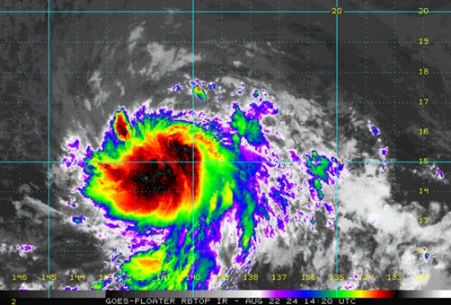
2024-08-22-12z 15.4N 140.3W 30 KNOTS
Tropical Storm Hone as of the 1100 AM HST Thu Aug 22 2024 Advisory

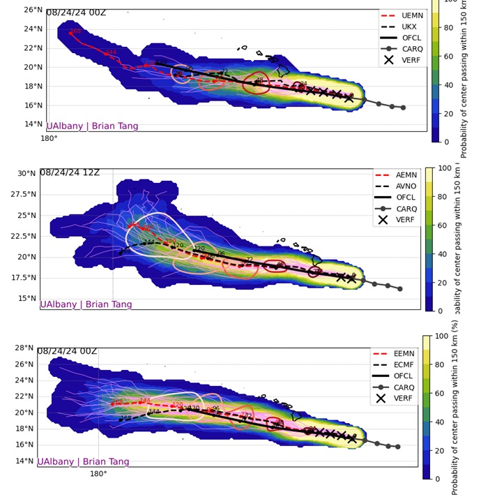
Recon and radar are showing that Hone is now a hurricane. 8-25-24-0715z

-Ciel

Edited by cieldumort (Sun Aug 25 2024 03:18 AM)


Post Extras: Print Post   Remind Me!   Notify Moderator  
cieldumort
Moderator


Reged:
Posts: 2409
Loc: Austin, Tx
Re: Invest 91E Lounge (Hawaii?) [Re: cieldumort]
      #115091 - Thu Aug 22 2024 10:56 AM


Invest 91E has become a tropical cyclone, presently estimated possibly conservatively to be a TD, CP ONE, and advisories will begin in the Central Pacific. Watches and even Warnings could be going up for Hawaii this week.


Post Extras: Print Post   Remind Me!   Notify Moderator  
cieldumort
Moderator


Reged:
Posts: 2409
Loc: Austin, Tx
Re: Tropical Storm Hone (Hawaii threat) [Re: cieldumort]
      #115093 - Sat Aug 24 2024 04:05 PM

Hone has been tracking a hair north of forecast and intensifying a little more than forecast. Satellite and recon suggests that the cyclone may be making a run at hurricane prior to passing west of the Big Island. A track a little on the stronger side and closer to or even directly over the Big Island is supported by a few of the ensemble members. Something to keep an eye on, as a hurricane watch or even warning is not out of the realm of possibility.


Above:
UKMET Ensembles 8-24-24-0z
GFS Ensembles 8-24-24-12z
ECMWF Ensembles 8-24-24-0z
Credit: Brian Tang


Post Extras: Print Post   Remind Me!   Notify Moderator  
Pages: 1


Extra information
1 registered and 48 anonymous users are browsing this forum.

Moderator:  

Print Topic

Forum Permissions
      You cannot start new topics
      You cannot reply to topics
      HTML is disabled
      UBBCode is enabled

Rating:
Topic views: 965

Rate this topic

Jump to

Note: This is NOT an official page. It is run by weather hobbyists and should not be used as a replacement for official sources. 
CFHC's main servers are currently located at
Hostdime.com in Orlando, FL.
Image Server Network thanks to Mike Potts and Amazon Web Services. If you have static file hosting space that allows dns aliasing contact us to help out! Some Maps Provided by:
Great thanks to all who donated and everyone who uses the site as well. Site designed for 800x600+ resolution
When in doubt, take the word of the National Hurricane Center