cieldumort
Moderator

Reged:
Posts: 2664
Loc: Austin, Tx
|
|
6:30AM CDT 10 September 2024 Update
With Francine, overnight a large area of convection shifted north and became part of the overall outer bands, with some minor shear affecting the core areas, which more or less kept it from intensifying overnight, but the system is now moving more northward and will begin moving more northeast through the day and is expected to become a hurricane by the afternoon.
The forecast has shifted to the right/east side of Vermilion bay in Louisiana, with most effects going to be felt on the eastern part of the system. Shear and dry air will likely affect it as it moves onshore, but not before getting into a category 2 hurricane by the time of landfall sometime late afternoon or early evening tomorrow, which is the official forecast. The question today and early tomorrow is how strong it may get, with the slow strengthening seen yesterday through this morning, it's less likely it'll reach major status, which is good news for Louisiana.
However there still be quite a bit of surge impacts near and east of the landfall point, rain impacts near and mostly east of the landfall point. Power outages are also likely in those areas. Don't evacuate unless local officials ask you to. But prepare today, since this is the last full day to do so.
2:30PM CDT 9 September 2024 Update
Francine now has a fairly well developed eye that is starting to come into view on the Brownsville, TX radar.
Preps for a Hurricane Francine should start to be made.
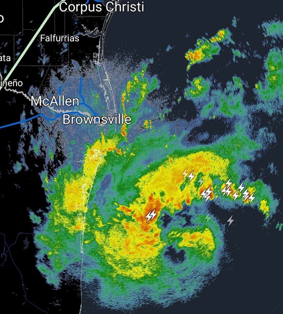
Above: KBRO Brownsville, TX Radar 2:22PM 9-9-24 2:22PM CDT
12:30PM CDT 9 September 2024 Update
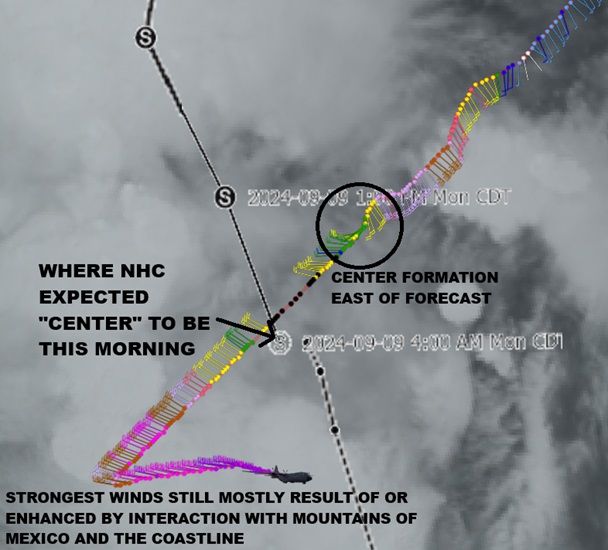
Tropical Storm Francine appears to be making a jump to the very deep convection associated with former Invest 90L/front well to the northwest of this morning's 10AM CDT Advisory. At the very least, the mean center of the two centers will be shifted back left, but if trends continue, the cyclone will more likely realign with the location to the northwest.
This would place more of Texas and Louisiana back in play. As this location is also significantly closer to the Texas coast than earlier, conditions are likely to begin deteriorating ahead of last forecast.
Francine is a hefty tropical cyclone, but not too large to prevent it from undergoing Rapid Intensification before landfall. Recon recently found a minimum pressure of about 996mb. This is six millibars lower than the 10AM CDT Advisory.
Francine is large enough and has enough time over the bathtub Gulf of Mexico to generate substantial storm surge. The cyclone also has a bountiful supply of precipitable water to work with and the mechanics to put it to use. Inland flooding will also occur, and could be significant.
9AM CDT 9 September 2024 Update
FRANCINE
PTC SIX is now Tropical Storm Francine and official word of this should come shortly.
The center of our tropical storm has formed east of where forecast to be at this point, and given the potential to strengthen quite a lot, possibly undergoing Rapid Intensification at least once before landfall, could track east of where 's pre-TC forecast suggested.
Interests from Louisiana to the Florida panhandle may want to begin paying very close attention, as a large and strong, possibly Major, hurricane, is likely knocking on the door by midweek.
7AM CDT 9 September 2024 Update
Potential Tropical Cyclone Six will likely become a tropical cyclone today and the next name up is Francine. Tropical Storm Watches now exist along the northern Mexico coastlines and now into Texas up to Port Mansfield. Watches will likely be extended northward later today. Landfall is currently forecast to be a strong category 1 hurricane somewhere along the Louisiana Coastline late Wednesday or early Thursday morning, in the cone range.
Conditions become much more conducive for development the closer the system gets to land, so there's a chance it may intensify more than forecast the closer it gets to Louisiana. Those in the area should likely prepare for a category 2 hurricane, or even low end 3 to be on the safe side, as then Francine has strong model support to still be strengthening as it makes landfall.
Two other area in the East Atlantic both have 60% chances to develop over the next 7 days.
10PM CDT 8 September 2024 Update
A Tropical Storm Watch has been issued for extreme southern Texas from Port Mansfield southward to the Mouth of the Rio Grande, likely the first of many for the United States. A Tropical Storm Watch is also in effect for Barra del Tordo to the Mouth of the Rio Grande.
A new recon flight is now departing to investigate SIX overnight, with several more already scheduled for the following two days and nights.
3:15PM CDT 8 September 2024 Update
NHC Advisories are being prepared for Storm SIX (PTC) in the Southwestern Gulf of Mexico. Still a bit broad and formative at this time, but with winds already 40-60 MPH and likely to become Francine tonight or Monday. Interests from Texas to Louisiana may want to begin paying closer attention as SIX has potential to become a significant hurricane.
Original Update
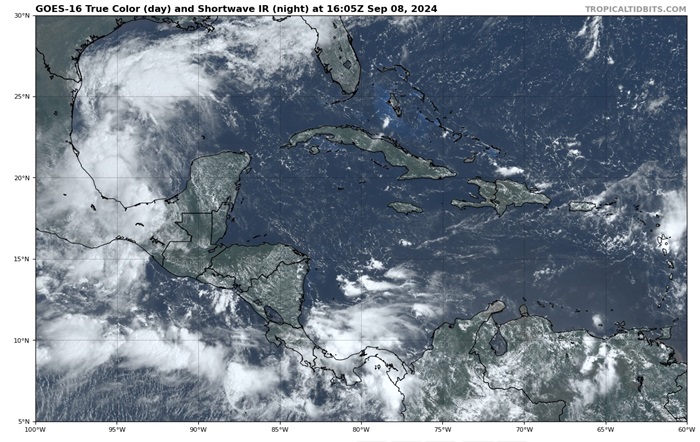
Above: Area of Interest in the western Gulf of Mexico. Image credit: Tropical Tidbits
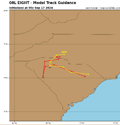
Francine, Gordon and Helene are the next names to be used in the 2024 Atlantic Hurricane Season and it is starting to look a lot like the basin has just come out hibernation this summer, exemplifying a hurricane season that has been anything but usual.
Advisories could soon be issued in the Gulf of Mexico for 91L/x90L that are just about to be checked out by recon. While initially, Advisories could be issued for a Potential Tropical Cyclone, or "PTC," it seems just as possible that recon finds a sufficiently organized system by the end of the day for TC classification, and as surface winds have already blowing at or above 35 knots, could go straight to Francine. 91L Forecast Lounge
Out in the Central Atlantic, Invest 92L continues to organize, although it has been choking on some dry air. Nonetheless, this Low could very well become Gordon or Helene, as there is also another Area of Interest behind it as well. Their odds are presently about a coin toss each. Both have a fair shot of becoming long-track Cabo Verde tropical cyclones. 92L Forecast Lounge
|
cieldumort
Moderator
Reged:
Posts: 2664
Loc: Austin, Tx
|
|
We should keep watch for future model and official forecast shifts a touch to the east with this
|
CFHC

Reged:
Posts: 197
Loc: East Central Florida
|
|
Recon's found the center NW of the 11AM EDT point, with the cloud tops warming this afternoon signaling no rapid intensification at least this afternoon , so I think the general forecast cone is pretty good a the moment. With the elongation I think it'll hold steady today, but watch for any cold/hot towers forming.
|
cieldumort
Moderator
Reged:
Posts: 2664
Loc: Austin, Tx
|
|
Product: Air Force Vortex Message (URNT12 KNHC)
Transmitted: 9th day of the month at 17:22Z
Agency: United States Air Force
Aircraft: Lockheed WC-130J Hercules with reg. number AF98-5308
Tropical Depression: Six (flight in the North Atlantic basin)
Mission Number: 3
Observation Number: 08
A. Time of Center Fix: 9th day of the month at 16:45:10Z
B. Center Fix Coordinates: 23.69N 95.85W
B. Center Fix Location: 186 statute miles (299 km) to the SE (146°) from Brownsville, TX, USA.
C. Minimum Height at Standard Level: 1,387m (4,551ft) at 850mb
D. Minimum Sea Level Pressure: 996mb (29.42 inHg)
E. Dropsonde Surface Wind at Center: From 140° at 5kts (From the SE at 6mph)
F. Eye Character: Open in the west
G. Eye Shape & Diameter: Circular with a diameter of 20 nautical miles (23 statute miles)
H. Estimated (by SFMR or visually) Maximum Surface Wind Inbound: Not Available
I. Location & Time of the Estimated Maximum Surface Wind Inbound (Undecoded): NA
J. Maximum Flight Level Wind Inbound: From 308° at 31kts (From the NW at 35.7mph)
K. Location & Time of the Maximum Flight Level Wind Inbound: 6 nautical miles to the SW (219°) of center fix at 16:43:30Z
L. Estimated (by SFMR or visually) Maximum Surface Wind Outbound: 47kts (54.1mph)
M. Location & Time of the Estimated Maximum Surface Wind Outbound: 55 nautical miles (63 statute miles) to the NE (47°) of center fix at 17:02:00Z
N. Maximum Flight Level Wind Outbound: From 133° at 58kts (From the SE at 66.7mph)
O. Location & Time of the Maximum Flight Level Wind Outbound: 12 nautical miles (14 statute miles) to the NE (44°) of center fix at 16:49:00Z
P. Maximum Flight Level Temp & Pressure Altitude Outside Eye: 16°C (61°F) at a pressure alt. of 1,523m (4,997ft)
Q. Maximum Flight Level Temp & Pressure Altitude Inside Eye: 20°C (68°F) at a pressure alt. of 1,524m (5,000ft)
R. Dewpoint Temp (collected at same location as temp inside eye): 18°C (64°F)
R. Sea Surface Temp (collected at same location as temp inside eye): Not Available
S. Fix Determined By: Penetration, Radar, Wind, Pressure and Temperature
S. Fix Levels (surface & flight level centers within 5nm of each other): Surface and 850mb
T. Navigational Fix Accuracy: 0.02 nautical miles
T. Meteorological Accuracy: 1 nautical mile
Remarks Section:
Maximum Flight Level Wind: 58kts (~ 66.7mph) which was observed 12 nautical miles (14 statute miles) to the NE (44°) from the flight level center at 16:49:00Z
|
|


 Threaded


