F
Current Radar or Satellite Image

Flhurricane.com - Central Florida Hurricane Center - Tracking Storms since 1995Hurricanes Without the Hype! Since 1995


Modeled CAG/TC with now 60% NHC odds within 7 days. Entire NW Carib & Gulf should monitor for potential hurricane development.
Days since last H. Landfall - US: Any 9 (Francine) , Major: 387 (Idalia) Florida - Any: 46 (Debby) Major: 387 (Idalia)


News Talkback >> 2024 News Talkbacks

Pages: 1
cieldumort
Moderator


Reged:
Posts: 2409
Loc: Austin, Tx
Hurricane Francine
      #115129 - Tue Sep 10 2024 08:12 PM

5:15PM CDT 11 September 2024 Update
Francine has made landfall in the southern Louisiana Parish of Terrebonne.
Quote:

SUMMARY OF 500 PM CDT...2200 UTC...INFORMATION
-----------------------------------------------
LOCATION...29.3N 91.3W
ABOUT 30 MI...45 KM SSW OF MORGAN CITY LOUISIANA
ABOUT 85 MI...140 KM WSW OF NEW ORLEANS LOUISIANA
MAXIMUM SUSTAINED WINDS...100 MPH...155 KM/H
PRESENT MOVEMENT...NE OR 45 DEGREES AT 17 MPH...28 KM/H
MINIMUM CENTRAL PRESSURE...972 MB...28.71 INCHES


4PM CDT 11 September 2024 Update
Category 2 Francine still intensifying heading into landfall. 972mb 100 MPH.

3:30PM CDT 11 September 2024 Update
Recon is finding winds at flight level of roughly 100 knots and this is also supported by area radar velocity data. This would support Category 2 at the furface using a reduction of 85-90% or so.

Preparations to protect life and property in warned locations should be rushed to completion and shelter taken.

10:30AM CDT 11 September 2024 Update

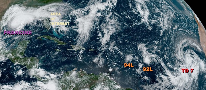
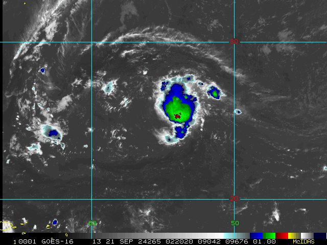
Above from left to right: Hurricane Francine, Area of Interest, newly-tagged Invest 94L, Invest 92L and newly upgraded TD-7

Hurricane Francine is a very dangerous high-end Category One Hurricane. As the Houston area was recently reminded, even Category One hurricanes can pack quite a punch and do tremendous damage, and take lives.

SUMMARY OF WATCHES AND WARNINGS IN EFFECT AS OF 10AM CDT 11 September:

A Storm Surge Warning is in effect for...
* Cameron Louisiana to the Mississippi/Alabama Border
* Vermilion Bay
* Lake Maurepas
* Lake Pontchartrain

A Hurricane Warning is in effect for...
* The Louisiana coast from Vermilion/Cameron Line eastward to Grand Isle

A Hurricane Watch is in effect for...
* Lake Maurepas and Lake Pontchartrain, including metropolitan New Orleans

A Tropical Storm Warning is in effect for...
* Louisiana coast east of Sabine Pass to Vermilion/Cameron Line
* East of Grand Isle Louisiana to the Alabama/Florida border
* Lake Maurepas and Lake Pontchartrain, including metropolitan New Orleans


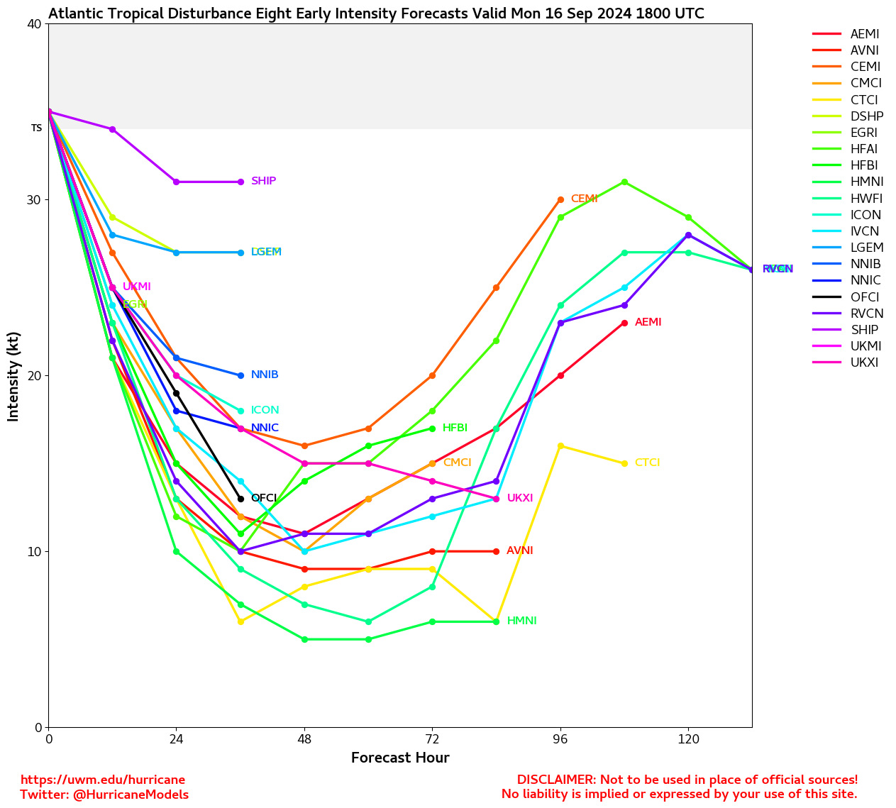
Elsewhere, we are keeping a keen eye out for possible development off the southeast coast late this weekend or early next week. We are also keeping a lookout on newly Invest tagged 94L that is nearing the Antilles but has been in far less than ideal conditions for development, Invest 92L behind that with about the same environment, and way out by the Cabo Verdes we are tracking newly-upgraded TD-7.

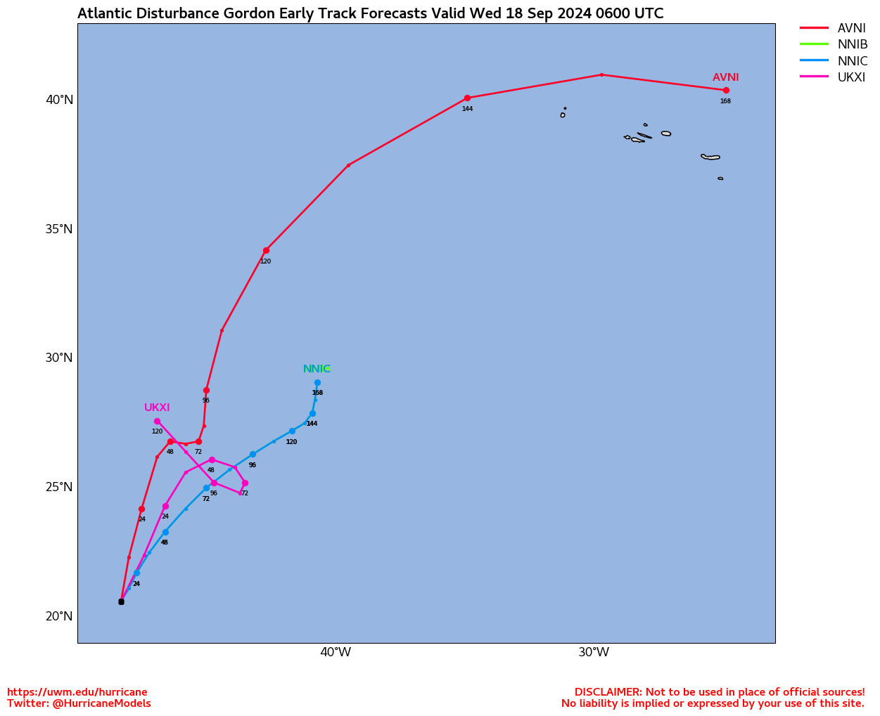
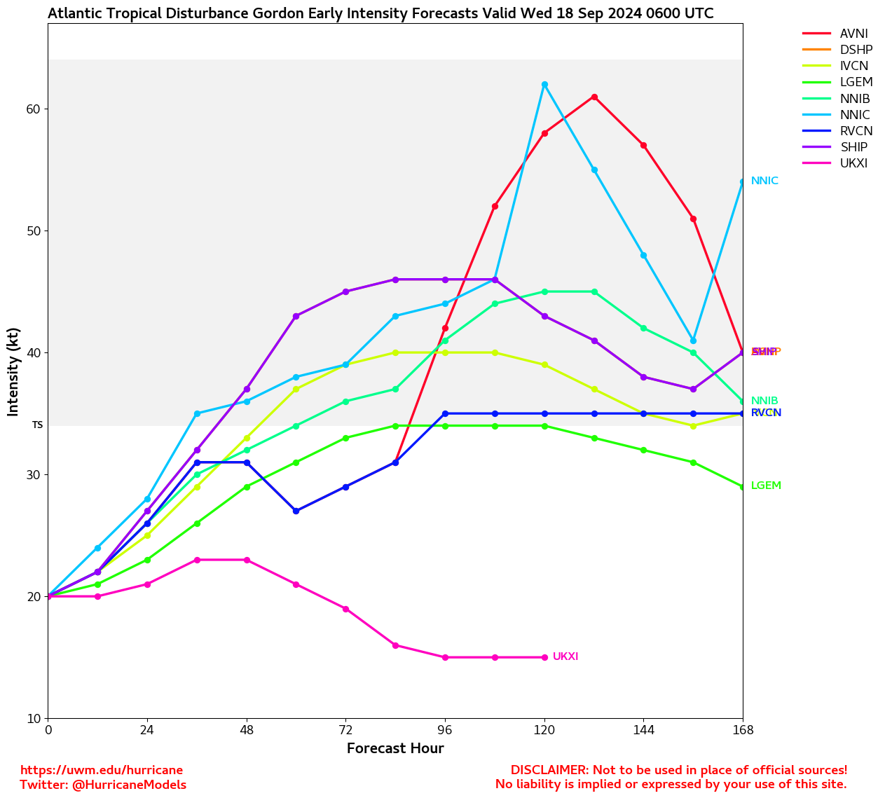
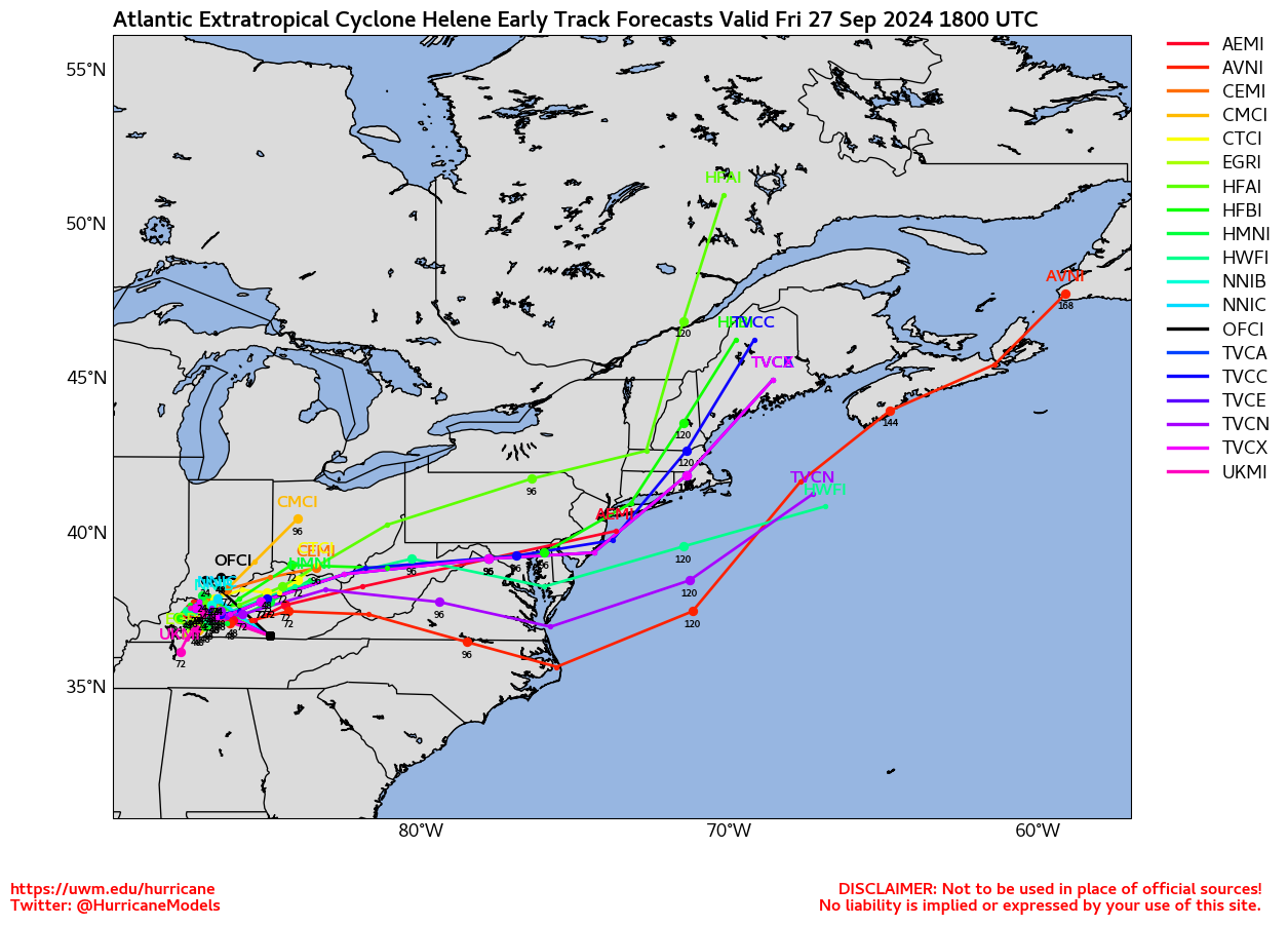
The next names on the list are Gordon and Helene.

Original Update

FRANCINE BECOMES A HURRICANE


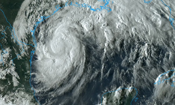
Recon this afternoon is finding Francine deepening markedly since earlier today. In addition, CONUS based radar has already been advertising a fascinating inner eye forming within Francine's large eye, and not by the more usual processes of a classic eyewall replacement cycle. Plus, satellite imagery highlights a healthy upper-level anticyclone over the Gulf, which Francine is benefiting from. All taken together, forecasts for a very stout tropical storm to a strong hurricane at landfall look largely intact, and landfall is now just hours away.

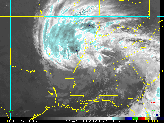
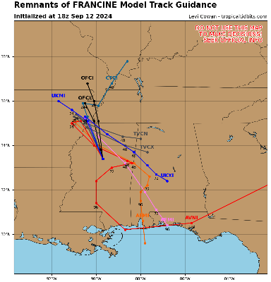
It is expected that shortly before, during or soon after landfall, extra-tropical transition will begin, with Francine interacting with a non-tropical cutoff low presently over Texas, but not without still producing intense hybrid to ultimately post-tropical weather even well inland.

Elsewhere, way out in the Atlantic we are now also tracking newly-tagged Invest 93L, as well as Invest 92L and a few other lower probability features.


Post Extras: Print Post   Remind Me!   Notify Moderator  
cieldumort
Moderator


Reged:
Posts: 2409
Loc: Austin, Tx
Re: Hurricane Francine [Re: cieldumort]
      #115131 - Wed Sep 11 2024 11:29 AM

There may be a few issues with the images between systems until our content providers and various servers get things sorted out. Shouldn't be long. Of note, TD 7 formed from 93L and not 92L. Newly-tagged Invest 94L is very close to 92L. Please see coming image on main page for clarification.
Ciel


Post Extras: Print Post   Remind Me!   Notify Moderator  
cieldumort
Moderator


Reged:
Posts: 2409
Loc: Austin, Tx
Re: Hurricane Francine [Re: cieldumort]
      #115132 - Wed Sep 11 2024 04:50 PM

Product: Air Force Vortex Message (URNT12 KNHC)
Transmitted: 11th day of the month at 20:40Z
Agency: United States Air Force
Aircraft: Lockheed WC-130J Hercules with reg. number AF96-5302
Storm Name: Francine
Storm Number & Year: 06 in 2024 (flight in the North Atlantic basin)
Mission Number: 14
Observation Number: 15

A. Time of Center Fix: 11th day of the month at 20:26:00Z
B. Center Fix Coordinates: 29.07N 91.60W
B. Center Fix Location: 83 statute miles (134 km) to the SSE (162°) from Lafayette, LA, USA.
C. Minimum Height at Standard Level: 2,904m (9,528ft) at 700mb
D. Minimum Sea Level Pressure: 974mb (28.77 inHg)
E. Dropsonde Surface Wind at Center: From 35° at 19kts (From the NE at 22mph)
F. Eye Character: Open in the southwest
G. Eye Shape & Diameter: Circular with a diameter of 50 nautical miles (58 statute miles)
H. Estimated (by SFMR or visually) Maximum Surface Wind Inbound: 75kts (86.3mph)
I. Location & Time of the Estimated Maximum Surface Wind Inbound: 36 nautical miles (41 statute miles) to the SE (129°) of center fix at 20:15:00Z
J. Maximum Flight Level Wind Inbound: From 225° at 99kts (From the SW at 113.9mph)
K. Location & Time of the Maximum Flight Level Wind Inbound: 28 nautical miles (32 statute miles) to the SE (128°) of center fix at 20:17:30Z
L. Estimated (by SFMR or visually) Maximum Surface Wind Outbound: 73kts (84.0mph)
M. Location & Time of the Estimated Maximum Surface Wind Outbound: 7 nautical miles to the WNW (296°) of center fix at 20:28:30Z
N. Maximum Flight Level Wind Outbound: From 60° at 73kts (From the ENE at 84.0mph)
O. Location & Time of the Maximum Flight Level Wind Outbound: 14 nautical miles (16 statute miles) to the WNW (303°) of center fix at 20:30:30Z
P. Maximum Flight Level Temp & Pressure Altitude Outside Eye: 13°C (55°F) at a pressure alt. of 3,040m (9,974ft)
Q. Maximum Flight Level Temp & Pressure Altitude Inside Eye: 18°C (64°F) at a pressure alt. of 3,052m (10,013ft)
R. Dewpoint Temp (collected at same location as temp inside eye): 9°C (48°F)
R. Sea Surface Temp (collected at same location as temp inside eye): Not Available
S. Fix Determined By: Penetration, Radar, Wind, Pressure and Temperature
S. Fix Level: 700mb
T. Navigational Fix Accuracy: 0.02 nautical miles
T. Meteorological Accuracy: 1 nautical mile

Remarks Section:

Maximum Flight Level Wind: 99kts (~ 113.9mph) which was observed 28 nautical miles (32 statute miles) to the SE (128°) from the flight level center at 20:17:30Z


Post Extras: Print Post   Remind Me!   Notify Moderator  
Pages: 1


Extra information
0 registered and 8 anonymous users are browsing this forum.

Moderator:  

Print Topic

Forum Permissions
      You cannot start new topics
      You cannot reply to topics
      HTML is disabled
      UBBCode is enabled

Rating:
Topic views: 779

Rate this topic

Jump to

Note: This is NOT an official page. It is run by weather hobbyists and should not be used as a replacement for official sources. 
CFHC's main servers are currently located at
Hostdime.com in Orlando, FL.
Image Server Network thanks to Mike Potts and Amazon Web Services. If you have static file hosting space that allows dns aliasing contact us to help out! Some Maps Provided by:
Great thanks to all who donated and everyone who uses the site as well. Site designed for 800x600+ resolution
When in doubt, take the word of the National Hurricane Center