cieldumort
Moderator

Reged:
Posts: 2497
Loc: Austin, Tx
|
|
Quote:
Did not take a west to east B-Line to South Florida?
Above: (2005)
Off the top of my head I'd venture to say a very similar angle, yes. Dissimilar genesis, less time to create a fetch of surge in the Gulf, less Florida real estate to blast with surge, possibly less surge-vulnerable coast, although possibly some similar baroclinic interaction and "cool side" feel/gusts once coming ashore.
It might be informative to know what others who rode out or tracked think of the similarities and dissimilarities. This is a highly unusual storm track forecast for Milton.
|
Kraig
Weather Hobbyist

Reged:
Posts: 86
Loc: Jupiter, Fl
|
|
The set up to was very similar, except since it was the last week of October the front pushing down the state (and the High behind the front) was much stronger. I live in Jupiter on the SE coast where re-entered the Atlantic. Immediately as the storm was past us, the NW winds brought temps in to the 60's that afternoon and lows that night into the high 40s. Lows in the Tampa area are shown to drop to the low 60's Thurs-Sun with 50's north of about Cedar Key. also had a forward speed that was near or over 30mph to the NE! Because of the forward speed and, high water levels that were very warm in the everglades and minimal terrain to disrupt the winds, was still questionably a 115mph Cat 3 (officially I think they could only prove 105mph though) leaving Florida down from 120mph at landfall.
|
JMII
Weather Master

Reged:
Posts: 546
Loc: Margate, Florida
|
|
Quote:
Did not take a west to east B-Line to South Florida?
It was more NE and formed at a lower latitude. went thru my backyard in NW Broward we got the eye wall, winds were pushing 90 mph. Without a doubt the worse storm I’ve been thru. No power for nearly 3 weeks.
Not liking this forecast at all. The has it as Cat 2 / 3 at landfall, shear will be increasing but only at the tail end of its gulf crossing. Models are still iffy on forward speed and overall strength but location wise it’s Tampa to points north or south by 70 miles or so.
--------------------
South FL Native... experienced many tropical systems, put up the panels for:
David 79 - Floyd 87 - Andrew 92 - Georges 98 - Frances 04 - Wilma 05 - Matthew 16 - Irma 17
Lost our St James City rental property to Ian 22
Edited by JMII (Sat Oct 05 2024 06:25 PM)
|
cieldumort
Moderator
Reged:
Posts: 2497
Loc: Austin, Tx
|
|
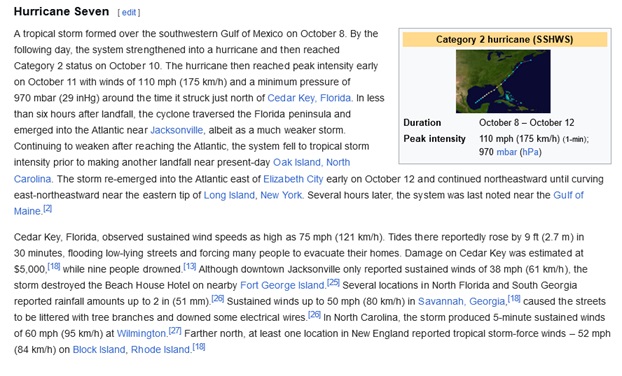
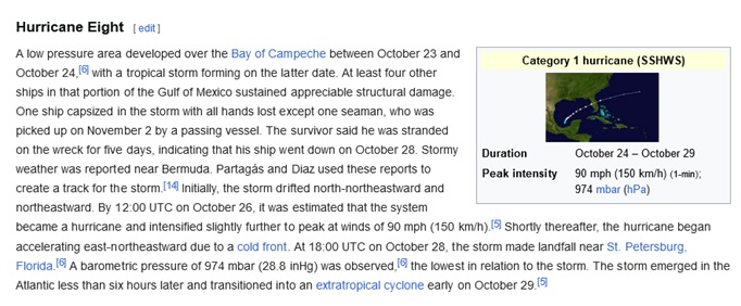
In recorded hurricane history, I've only found two analog-ish post-September hurricanes. Both, as far as we know, were quite a bit weaker than what is forecast with Milton, and the population of Florida back then was under 400,000 in 1888 and less than 150,000 in 1859. For the entire state.
TC 7 of 1888
TC 8 of 1859
|
cieldumort
Moderator
Reged:
Posts: 2497
Loc: Austin, Tx
|
|
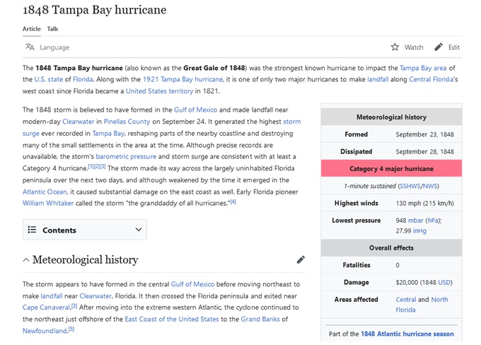
Matt Lanza (editor @TheEyewallWx and also @SpaceCityWx) brings up the 1848 Tampa Bay Hurricane as a possible analog of sorts to a Tampa Bay-specific landfall. Differences exist as to time of year (September vs October) and location of genesis (largely unknown, but thought to be the Gulf), apply. Track-wise, a Major landfall on the west coast of central Florida is exceedingly rare no matter what.
|
JumadukeFL
Registered User
Reged:
Posts: 4
|
|
We are licking our wounds from Helene. Admittedly, we are 99% better off than NC, but we were 60 miles from Helene's landfall, on the East side. Our property looks like a war zone (lost at least a dozen huge trees). We slept in our closet (our "strong room") when Helene made landfall, and went six days without power. Our neighbor has a vacation property next door, but lives fulltime in St. Pete; his neighborhood had record flooding, and he's told us that the majority of his neighbors' curbs are currently covered with drywall, carpet, kitchen cabinets, and furniture destroyed by the seawater. Now this ... and Milton looks to be threatening our firstborn as well, in Ft. Myers. This is a repeat of the crisis she had during Ian; evacuating to us wasn't the best option then, and she headed to the East coast, but what about now? Does she fight 146 hours of traffic through Tampa to get to us this time, or does she ride it out down there? Argh.
|
MikeC
Admin
Reged:
Posts: 4635
Loc: Orlando, FL
|
|
0z models overall shifted left, but the consensus model TVCN hasn't really changed at all (just time plot points) I suspect the stays the course on the 11PM Track and probably intensity wise too, although it's a good compromise between some of the models like the hurricane ones that show it strengthening a lot more, only to hit wild shear just before landfall and weaken rapidly. Landfall timing is the interesting bit, that could change.
|
Kraig
Weather Hobbyist
Reged:
Posts: 86
Loc: Jupiter, Fl
|
|
I think we will really know a lot more by early Monday morning. The first Hunter aircraft will be in the storm tomorrow collecting data that will be used in the models run Sunday night and the results will be in between midnight and 3 am Monday morning. All the results will be part of the 5am advisory, Hopefully immediate decisions can be made regarding evacuations and they go smoothly. I hope after Helene more people that can will leave early and those that don't will heed the evac warnings when issued.
|
cieldumort
Moderator
Reged:
Posts: 2497
Loc: Austin, Tx
|
|
It would be nice to have recon before tossing my max lifetime intensity bid in for Milton, but here it goes. Of course, tropical cyclones like Milton are far more than just their maximum sustained wind speed, and I'm a strong proponent of moving away from the Saffir-Simpson scale to something akin to what SPC uses in their graphics for severe thunderstorm/tornado outlooks, which for TCs would include serious impacts such as surge, inland flooding, wind damage and tornadoes, for example.
Max lifetime sustained winds for Milton (my best guess).
40KTS (Present 10PM Advisory) <1%
45-50 KTS: 2%
60 KTS: 3%
65-70 KTS: 5%
75-80 KTS: 6%
85-95 KTS: 7%
100-110 KTS: 17%
115-135 KTS: 28%
140-155 KTS: 22%
160+ KTS: 10%
Or another way of looking at this, I think there is a roughly 95% chance of Milton becoming a hurricane of any intensity, a 77% chance of becoming a Major, a 60% chance of becoming a high-end Major (Cat 4 or 5), and about one-in-three odds of becoming a Cat 5, prior to making landfall on Florida.
|
IsoFlame
Weather Analyst

Reged:
Posts: 370
Loc: One block off the Atlantic Oce...
|
|
5AM Day 4 forecast has Milton tracking nearly on top of my location (29.1N 80.9W) while maintaining hurricane force at 80 kts with gusts to 100 kts when it emerges into the Atlantic off Daytona Beach:
EXTENDED OUTLOOK. NOTE...ERRORS FOR TRACK HAVE AVERAGED NEAR 125 NM
ON DAY 4 AND 175 NM ON DAY 5...AND FOR INTENSITY NEAR 15 KT EACH DAY
OUTLOOK VALID 10/0600Z 29.0N 80.7W
MAX WIND 80 KT...GUSTS 100 KT.
Milton could be a somewhat smaller version of Helene... a major hurricane strengthening up to land fall, with forward speed carrying the momentum of hurricane-force winds well inland- in this case across the entire central Florida peninsula.
--------------------
CoCoRaHS Weather Observer (FL-VL-42) & Surf Forecaster: https://www.surf-station.com/north-florida-surf-forecast-3/
|
MikeC
Admin
Reged:
Posts: 4635
Loc: Orlando, FL
|
|
6z Icon is near Port Charlotte, Euro is near Sarasota, is ST. Pete, Canadian is Ft. Myers. 6z TVCN Shifted a bit south today to Venice (Was St. Pete), the 0z Hurricane Models all come in North of Tampa, (HAFS-A And HMON to Crystal River, HWRF to Reddington Beach, HAFS-B to Homossasa Springs) At or North of Tampa is worse for Tampa Bay onshore surge, but track doesn't really mean much for the other effects. (Note on exit to the Atlantic the the opposite onshore wind surge is left (or north) of the storm)
The southerly models are forecasting a weaker storm, the northern ones a stronger storm. Recon data will help some for the models as the plane should be around there in a hour or two. The current track oiver Tampa and Orlando and exiting into the Atlantic near Cape Canaveral is solid right now based on what's known currently. I'm not convinced Milton will get overly strong, but it's important to watch for it, if it does go stronger than forecast the more northerly tracks seem more likely.
|
JMII
Weather Master
Reged:
Posts: 546
Loc: Margate, Florida
|
|
I don’t think I’ve ever seen a forecast that states anything from Cat 1 to Cat 5 is possible due to the interaction with an approaching front. It could transition to extra-tropical just before or after landfall. They note it’s a small storm thus rapid fluctuations are possible. My main concern continues to be surge given the area in the cone. Ft Myers and Tampa are both VERY surge prone due to shape of the coastline. Forward speed will be critical here, a fast mover can’t pile up as much water and the speed factor is another wild card the mentions.
--------------------
South FL Native... experienced many tropical systems, put up the panels for:
David 79 - Floyd 87 - Andrew 92 - Georges 98 - Frances 04 - Wilma 05 - Matthew 16 - Irma 17
Lost our St James City rental property to Ian 22
|
Kraig
Weather Hobbyist
Reged:
Posts: 86
Loc: Jupiter, Fl
|
|
Don't look at the week two ! Another /Charley type track coming up and hitting the west coast and then exiting the treasure/space coast! Geeez!
|
cieldumort
Moderator
Reged:
Posts: 2497
Loc: Austin, Tx
|
|
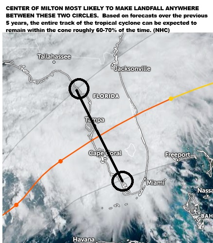
Seeing a lot of reaction on social media to the slight adjustment south of the center line with the 10AM Advisory. I know most of us here already know this, but it's still probably a good time to reiterate that shifts in the center line will continue to occur up to, into and after landfall, and that 's own studies have shown that this far out the actual track could be many tens of miles either side of the current center line, and even outside of the cone entirely roughly 30-40% of the time.
|
Ed Ardzinski
Registered User
Reged:
Posts: 5
|
|
Yes, that slight change might put me in the northern half of the eyewall in Northern Pinellas. Joy.
Looking at the nullschool rendering it seem that most of the shear is in the boundary layer and the central region is spinning close to a solid body. Good signs for explosive growth. Guessing this could be a hurricane by the 5 PM advisory,
|
MikeC
Admin
Reged:
Posts: 4635
Loc: Orlando, FL
|
|
12z shifted left from St. Pete to well north of Tampa closer to Homosassa springs, and 12Z Icon shifted left to Sarasota, only remains in Naples so far. This is just after the 11am track shift south, so I'd imagine the puts the breaks on any more southerly track adjustments at 5pm.
Also Milton is primed for RI today.
|
bob3d
Weather Hobbyist

Reged:
Posts: 59
Loc: Pasco County, Florida
|
|
Quote:
...Guessing this could be a hurricane by the 5 PM advisory,
I am anticipating the same thing... Hurricane by 5PM today.
--------------------
bob
Time in West Central Florida: 51 years
|
Kraig
Weather Hobbyist
Reged:
Posts: 86
Loc: Jupiter, Fl
|
|
Generally speaking, stronger and deeper hurricanes tend to move more poleward as they are moving east to west in the Atlantic. Would this also be true for a storm like Milton moving east or northeast? Just wondering if the models that that are showing a strongest Milton (more the hurricane specific models) are the northern most and the weaker Milton models (Euro, Canadian, etc) are the southernmost with the in between! As Milton is seeming to want to get strong quickly, this may draw him towards the more northern solutions…
|
criscr0smind
Registered User

Reged:
Posts: 2
|
|
and all this rain is just making it worse, we've already had 2 inches today in northeast palm beach county, on ground that is already saturated.
|
MikeC
Admin
Reged:
Posts: 4635
Loc: Orlando, FL
|
|
12z euro shifted from Sarasota right/north to Bradenton, the HMON, HAFS A & B all range from St. Pete Beach to About Tarpon Springs. The hurricane models rapidly strengthen it, but also weaken Milton about 6-12 hours before landfall..
|


 Threaded


