cieldumort
Moderator

Reged:
Posts: 2669
Loc: Austin, Tx
|
|
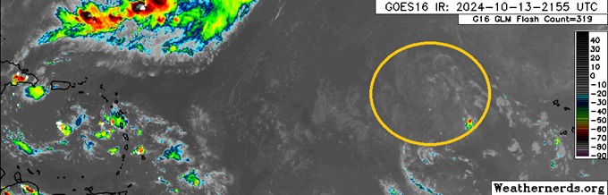
A dry but well defined area of low pressure in the eastern Tropical Atlantic is unlikely to cook up much organized deep convection over the next few days as it tracks generally west, but has increasing model support to encounter less hostile to even favorable conditions for development once approaching, near or over the Antilles, and given that such a scenario could place many islands in play for a tropical cyclone, we are starting a lounge on this feature at this time.
The Low has already been Invest tagged 94L, and to prevent confusion with last month's 94L, the title is "October 94L Lounge."
NHC development odds at the time of this original post are an almost nonexistent 10% within 48 hours, but ramps up to 40% within 7 days.
More details to come
94L developed a well-defined circulation overnight and this morning with better measurements has been confirmed to have become Tropical Storm Oscar. The title has been updated accordingly 10-19-24
Ciel
Edited by cieldumort (Sat Oct 19 2024 10:48 AM)
|
cieldumort
Moderator
Reged:
Posts: 2669
Loc: Austin, Tx
|
|
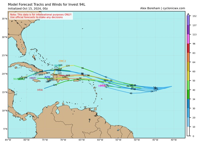
10-15-0z early model output for 94L. Wind in knots (color). Time in hours (number stamps)
|
JMII
Weather Master

Reged:
Posts: 547
Loc: Cape Coral & Margate, FL
|
|
There is a ton of interest around the "next" storm when/where ever it arrives. Even non-weather people at my company, many of whom don't even live in FL are talking about it like its a sure thing. Those of those familiar with the tropics know these things bubble up and fizzle out throughout the season.
--------------------
South FL Native... experienced many tropical systems, put up the panels for:
David 79 - Floyd 87 - Andrew 92 - Georges 98 - Frances 04 - Wilma 05 - Matthew 16 - Irma 17
Lost our St James City rental property to Ian 22
|
cieldumort
Moderator
Reged:
Posts: 2669
Loc: Austin, Tx
|
|
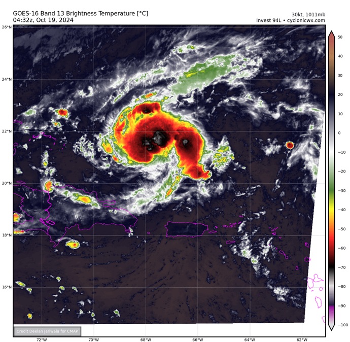
Invest 94L is approaching the southeastern Bahamas and looking yet again a bit more organized this late Friday night. Several models, including the , have been insistent on this becoming a TC by Sunday, and it is in a favorable environment of light shear and sufficient moisture to pull this off.
Intensity-wise, given its relatively small size and favorable environment, if a TC has indeed already formed or soon does form (a little difficult to discern without much in the way of reporting stations out over this part of the ocean - and also given that all recon missions scheduled for it on Friday got scrubbed), 94L has potential to surprise on the upside.
NHC development odds as of 8PM EDT Friday Oct 18 were 30% within 48 hours, which will probably be going up in short order.
|
cieldumort
Moderator
Reged:
Posts: 2669
Loc: Austin, Tx
|
|
Recon is finding Oscar is probably already a hurricane (and may have been so for a while now). This is recon's first mission, as yesterday's flights were scrubbed.
Significant updates to models and official forecasts are imminent for the southeastern Bahamas and vicinity.
|
cieldumort
Moderator
Reged:
Posts: 2669
Loc: Austin, Tx
|
|
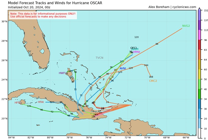
With hurricane models given an opportunity to play catch-up with the actual intensity and organization of Oscar, the 18Z runs out today are coming in hot. These are all plausible, but need to be tempered with the understanding that Oscar is a very small tropical cyclone, susceptible to rapid decreases of intensity and organization, not just increases.
The structure of Oscar on IR satellite as of 23z does not line up well with the 18Z forecasts below.
Some of today's primary 18Z Hurricane Model Runs
HAFS-A: Crosses Grand Turk by 0z as a Cat 3. (Unsupported by tonight's IR). Landfall mid-morning tomorrow, the 20th, on southeast Cuba as a Cat 4.
HAFS-B: Crosses by Grand Turk by 0z as a Cat 2/3 (Unsupported by tonight's IR). Scrapes by Grand Inagua, Bahamas predawn tomorrow as a Cat 5. Landfall on southeast Cuba midday tomorrow, the 20th, as a Cat 4/5.
HWRF: Crosses Big Amergris Cay by 0z as a Cat 3 (Unsupported by tonight's IR). Landfall on extreme southeast Cuba midday tomorrow as a Cat 2.
|
cieldumort
Moderator
Reged:
Posts: 2669
Loc: Austin, Tx
|
|
Oscar appears to be intensifying again tonight after a pause or slight weakening at the end of this afternoon's recon mission until just a little while ago. Recent IR and microwave data could support Cat 2 at present or soon.
Some 10-20 0z model runs within wind in knots (color) and time stamps (numbers)
|


 Threaded


