MikeC
Admin
Reged:
Posts: 4811
Loc: Orlando, FL
|
|
2:00PM EDT 19 October 2024 Update
...HURRICANE WARNING ISSUED FOR TURKS AND CAICOS ISLANDS AND SOUTHEAST BAHAMAS... Quote:
SUMMARY OF 200 PM EDT...1800 UTC...INFORMATION
----------------------------------------------
LOCATION...21.4N 70.6W
ABOUT 165 MI...260 KM ESE OF THE SOUTHEASTERN BAHAMAS
ABOUT 470 MI...755 KM E OF CAMAGUEY CUBA
MAXIMUM SUSTAINED WINDS...80 MPH...130 KM/H
PRESENT MOVEMENT...W OR 270 DEGREES AT 12 MPH...19 KM/H
MINIMUM CENTRAL PRESSURE...989 MB...29.21 INCHES
WATCHES AND WARNINGS
--------------------
CHANGES WITH THIS ADVISORY:
The government of the Bahamas has issued a Hurricane Warning for the Turks and Caicos Islands and the Southeastern Bahamas.
The government of Cuba has issued a Hurricane Watch for the provinces of Guantanamo, Holguin, and Las Tunas.
SUMMARY OF WATCHES AND WARNINGS IN EFFECT:
A Hurricane Warning is in effect for...
* Turks and Caicos Islands
* Southeastern Bahamas
A Hurricane Watch is in effect for...
* Cuban Provinces of Guantanamo, Holguin, and Las Tunas
A Tropical Storm Warning is in effect for...
* Cuban Provinces of Guantanamo, Holguin, and Las Tunas
A Tropical Storm Watch is in effect for...
* Cuba Provence of Camaguey
9:30AM EDT 19 October 2024 Update
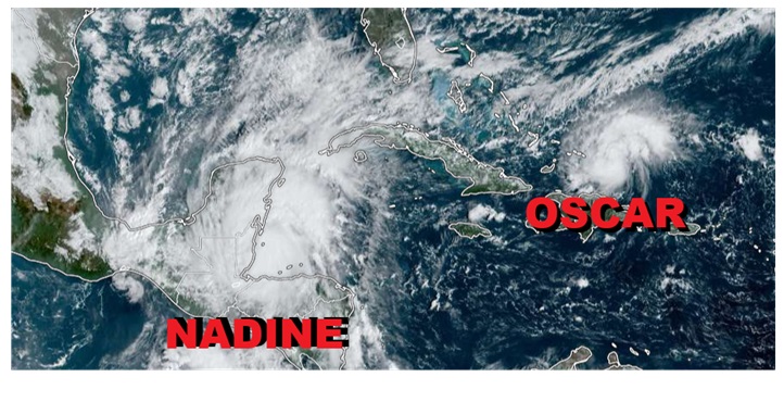
Potential Tropical Cyclone FIFTEEN is now Tropical Storm Nadine just offshore of Belize, and this morning, Invest 94L has become Tropical Storm Oscar, just east of the Turks and Caicos.
Ciel
9:30PM EDT 18 October 2024 Update
FIFTEEN is forecast to become Nadine prior to making landfall along or near Belize this weekend, and we do have a forecast lounge up on this system: Nadine Forecast Lounge
Ciel
4:30PM EDT 18 October 2024 Update
Invest 95L in the northwest Caribbean is now PTC FIFTEEN and Advisories are being issued. Those with interests in Central America and the Yucatan may want to begin paying close attention as a potentially flood-producing tropical cyclone is likely this weekend.
Ciel
6:15PM EDT 13 October 2024 Update
Invest 94L in the eastern Tropical Atlantic could become a concern later this week for portions of the Antilles, and we have started a Forecast Lounge on it Oscar Forecast Lounge
Ciel
Original Update
The last advisories on Milton have been issued and beyond Milton, Leslie is still churning, and invest 94L is also potentially the next system in the eastern Atlantic that may make it all the way to the Caribbean. This year has a lot of late activity in the MDR, which is fairly unusual for October, since typically we start looking closer in toward the Gulf and Western Caribbean for development this time of year.
Milton had significant impacts to Florida from tornadoes, to rain to surge and wind, but the rapid shear induced weakening prevented the truly catastrophic scale.
News Media (East Central Florida):
Television:
Newspapers:
News Radio:
Check local media and officials when a storm is approaching your area.
|
cieldumort
Moderator

Reged:
Posts: 2664
Loc: Austin, Tx
|
|
Product: Air Force Vortex Message (URNT12 KNHC)
Transmitted: 19th day of the month at 17:00Z
Agency: United States Air Force
Aircraft: Lockheed WC-130J Hercules with reg. number AF98-5308
Storm Name: Oscar
Storm Number & Year: 16 in 2024 (flight in the North Atlantic basin)
Mission Number: 2
Observation Number: 03
A. Time of Center Fix: 19th day of the month at 16:38:10Z
B. Center Fix Coordinates: 21.33N 70.37W
B. Center Fix Location: 50 statute miles (81 km) to the E (101°) from Cockburn Town, Turks and Caicos Islands (U.K.).
C. Minimum Height at Standard Level: 1,380m (4,528ft) at 850mb
D. Minimum Sea Level Pressure: 991mb (29.27 inHg)
E. Dropsonde Surface Wind at Center: From 125° at 3kts (From the SE at 3mph)
F. Eye Character: Closed
G. Eye Shape & Diameter: Circular with a diameter of 3 nautical miles
H. Estimated (by SFMR or visually) Maximum Surface Wind Inbound: 63kts (72.5mph)
I. Location & Time of the Estimated Maximum Surface Wind Inbound: 1 nautical miles to the SE (133°) of center fix at 16:37:30Z
J. Maximum Flight Level Wind Inbound: From 217° at 61kts (From the SW at 70.2mph)
K. Location & Time of the Maximum Flight Level Wind Inbound: 1 nautical miles to the SE (133°) of center fix at 16:37:30Z
L. Estimated (by SFMR or visually) Maximum Surface Wind Outbound: 70kts (80.6mph)
M. Location & Time of the Estimated Maximum Surface Wind Outbound: 4 nautical miles to the WNW (301°) of center fix at 16:39:30Z
N. Maximum Flight Level Wind Outbound: From 43° at 73kts (From the NE at 84.0mph)
O. Location & Time of the Maximum Flight Level Wind Outbound: 6 nautical miles to the WNW/NW (304°) of center fix at 16:40:00Z
P. Maximum Flight Level Temp & Pressure Altitude Outside Eye: 15°C (59°F) at a pressure alt. of 1,525m (5,003ft)
Q. Maximum Flight Level Temp & Pressure Altitude Inside Eye: 20°C (68°F) at a pressure alt. of 1,518m (4,980ft)
R. Dewpoint Temp (collected at same location as temp inside eye): 19°C (66°F)
R. Sea Surface Temp (collected at same location as temp inside eye): Not Available
S. Fix Determined By: Penetration, Radar, Wind, Pressure and Temperature
S. Fix Levels (surface & flight level centers within 5nm of each other): Surface and 850mb
T. Navigational Fix Accuracy: 0.02 nautical miles
T. Meteorological Accuracy: 1 nautical mile
Remarks Section:
Maximum Flight Level Wind: 73kts (~ 84.0mph) which was observed 6 nautical miles to the WNW/NW (304°) from the flight level center at 16:40:00Z
|
IsoFlame
Weather Analyst

Reged:
Posts: 411
Loc: One block off the Atlantic Oce...
|
|
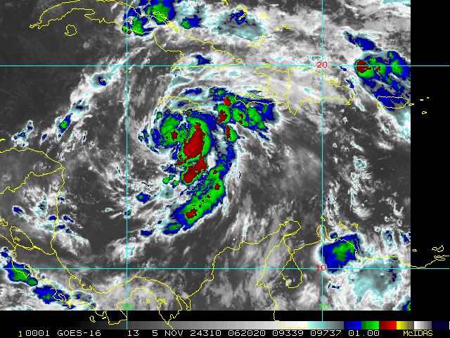
I think Florida is out of the woods for the rest of October given the dominate high that has settled in over the southeast US coast. Still, plenty of fuel remaining in the Caribbean Sea, and consistent model runs suggest a large area of low pressure will try to spin up a TC during the first week in November- possibly becoming a hurricane tracking to the NE of Puerto Rico by election day.
This fall's late hurricane season set-up reminds me of 1984 when a Thanksgiving nor-easter ramped up due to strong high pressure holding over the eastern seaboard combined with an area of low pressure drifting north in the Bahamas to produce near-hurricane-force onshore winds and 8-10" of rain along Florida's central east coast for several days, leading to severe erosion and coastal flooding. At the time, worked at Long Point Park and lived on a sailboat anchored in a hurricane hole near Sebastion Inlet. Water levels in the Indian River Lagoon rose due to the flooding rains, onshore flow combined with lunar peak tides to produce levels 3-4' above normal. We told campers in the park to leave immediately or shelter in place as the water inundated the park.
--------------------
CoCoRaHS Weather Observer (FL-VL-42) & Surf Forecaster: https://www.surf-station.com/north-florida-surf-forecast-3/
|
|


 Threaded


