IsoFlame
Weather Analyst

Reged:
Posts: 413
Loc: One block off the Atlantic Oce...
|
|
Quote:
This being the climatological peak of the season, the focus for development will begin to shift more toward the Caribbean and the Gulf. If the preseason forecasts are to be verified, a later season peak may be on tap (or not). 
Given the near-record warm and untapped SST's in this portion of the Atlantic basin, that is the horse that I'd put my money on. Look at the convection in the western Caribbean Sea and Bay of Campeche that is currently firing there, all that is needed is for the CAG to position favorably south of the unusual and persistent late summer frontal boundary
--------------------
CoCoRaHS Weather Observer (FL-VL-42) & Surf Forecaster: https://www.surf-station.com/north-florida-surf-forecast-3/
|
IsoFlame
Weather Analyst
Reged:
Posts: 413
Loc: One block off the Atlantic Oce...
|
|
Quote:
Given the near-record warm and untapped SST's in this portion of the Atlantic basin, that is the horse that I'd put my money on. Look at the convection in the western Caribbean Sea and Bay of Campeche that is currently firing there, all that is needed is for the CAG to position favorably south of the unusual and persistent late summer frontal boundary
Above post I made 5 days ago still valid... Impressive tropical wave exiting the extreme NW Carribean Sea this morning, crossing the northern Yucatan Peninsula, headed into the Bay of Campeche later this week. Not highlighted in the 7-day, it might bear watching if it can stay clear of land, avoid shear in the GOMEX and linger over the near seasonal peak sea temps in this part of the basin.
--------------------
CoCoRaHS Weather Observer (FL-VL-42) & Surf Forecaster: https://www.surf-station.com/north-florida-surf-forecast-3/
|
MikeC
Admin
Reged:
Posts: 4831
Loc: Orlando, FL
|
|
I'm watching the 20% area (yellow) area, the orange area may develop, but the yellow area is more likely to have land impacts. Although at a week out you'd expect better agreement in modeling, we just don't have it.
|
IsoFlame
Weather Analyst
Reged:
Posts: 413
Loc: One block off the Atlantic Oce...
|
|
Last several runs of the spin up a slow-moving major hurricane in the central Bahamas or in the Florida straits late in the first week of October.
Regardless, what has my attention is the possibility of a prolonged onshore flow produced by a stacked 50mb gradient between a slow-moving tropical system and a strong high anchored over the eastern seaboard coinciding with the highest lunar tidal cycle of Fall... stay tuned
--------------------
CoCoRaHS Weather Observer (FL-VL-42) & Surf Forecaster: https://www.surf-station.com/north-florida-surf-forecast-3/
|
bob3d
Weather Hobbyist

Reged:
Posts: 65
Loc: Pasco County, Florida
|
|
Useful discussion on the tropical forecast:
HurricaneTrack
--------------------
bob
Time in West Central Florida: 52 years
|
IsoFlame
Weather Analyst
Reged:
Posts: 413
Loc: One block off the Atlantic Oce...
|
|
While watching closely, I'm looking past 93 and 94L (both which models keep east of Florida) to potential threats in early October..The last 3 runs of the all suggest an extended period (nearly week-long) of strong onshore easterly flow across the Florida peninsula due to the gradient between strong high pressure anchored over the eastern seaboard to the north and an intensifying TC (possibly becoming a major hurricane) to the south near Cuba. If this scenario plays out, the timing couldn't be worse as it will coincide with the highest lunar tides of the month peaking on the 9th.
--------------------
CoCoRaHS Weather Observer (FL-VL-42) & Surf Forecaster: https://www.surf-station.com/north-florida-surf-forecast-3/
|
IsoFlame
Weather Analyst
Reged:
Posts: 413
Loc: One block off the Atlantic Oce...
|
|
Forecast has Imelda tracking north offshore from the Cape while strengthening to a hurricane about the same time ground swell from Major Hurricane Humberto filters in. Coastal Volusia will have some serious erosion from the combination of Imelda's N/NE wind swell and Humberto's long period easterly ground swell Tuesday/Wednesday. Late in the week high pressure is forecast to build down the east US coast, tightening the gradient once again with a nor'easter likely leading into and over the weekend.
The first 10 days in October will be a period of strong onshore winds combined with hurricane ground swells. Surf run-up and beach over-wash could be problematic along the Volusia coast with Oct 8-10th peak lunar/Fall tides arriving.
--------------------
CoCoRaHS Weather Observer (FL-VL-42) & Surf Forecaster: https://www.surf-station.com/north-florida-surf-forecast-3/
|
MichaelA
Weather Analyst

Reged:
Posts: 956
Loc: Pinellas Park, FL
|
|
Imelda and Humberto aside, there is a low level low in the central Gulf as evidenced in satellite imagery and wind flow on https://earth.nullschool.net/#current/wi...=-82.691,27.833. It’s a shallow circulation existing below 500mb, though.
--------------------
Michael
PWS
|
IsoFlame
Weather Analyst
Reged:
Posts: 413
Loc: One block off the Atlantic Oce...
|
|
The GOMEX is an untapped powder keg just waiting for late season atmospheric parameters to align in October. Last several runs of the have suggested that a TC will spin up in the sub-basin by mid-month. Let's see fi the 18Z backs up the previous 2 runs...
--------------------
CoCoRaHS Weather Observer (FL-VL-42) & Surf Forecaster: https://www.surf-station.com/north-florida-surf-forecast-3/
|
IsoFlame
Weather Analyst
Reged:
Posts: 413
Loc: One block off the Atlantic Oce...
|
|
Just when you thought conditions along the east coast couldn't get worse after over a week of strong onshore wind combined with higher lunar tides exacerbating beach erosion:
A strong cold front will then move across the southeastern states on Wednesday, crossing the southeast Georgia waters late on Wednesday night and the northeast Florida waters on Thursday. Meanwhile, strong high pressure building over New England will wedge down the southeastern seaboard on Thursday, creating a surge of strong northeasterly winds and building seas. Low pressure is expected to develop east of Cape Canaveral on Friday, with this feature then moving slowly northward, likely approaching the Carolina Coast this weekend. Small Craft Advisory conditions will overspread our local waters on Thursday, and Gale Watches will likely be required later this week as winds frequently gust to Gale Force by Thursday night and Friday. SATURDAY: North winds 30 to 40 knots. Seas 11 to 14 feet, occasionally to 18 feet. Intracoastal waters extremely rough.
--------------------
CoCoRaHS Weather Observer (FL-VL-42) & Surf Forecaster: https://www.surf-station.com/north-florida-surf-forecast-3/
|
cieldumort
Moderator

Reged:
Posts: 2682
Loc: Austin, Tx
|
|
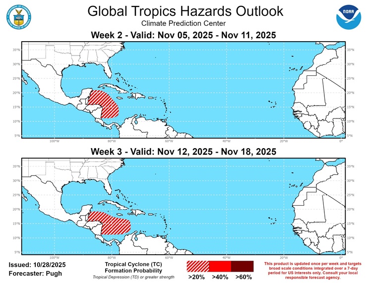
CPC Week 2 and 3 outlook highlights the Caribbean with >20% chances each week for development. There has been some on and off global and ensemble model support for this. Both CAG and wave opportunities are suggested.
|
IsoFlame
Weather Analyst
Reged:
Posts: 413
Loc: One block off the Atlantic Oce...
|
|
Post historic Melissa, the obese dame has been warming up her vocal cords on the 2025 hurricane season's conclusion. However, some medium range models say not so quick on belting out the final chorus. There is plenty of fuel in the way of well-above normal SST's in the western Caribbean and the southern GOMEX. Last several days, modeling has been toying with a depression, PTC or tropical storm spinning up in the gyre in the far western Caribbean around the 13th of November, then drifting NNW to a position in the NW Caribbean near the Yucatan Peninsula.where it sits for several days without much development. Will it survive interaction with the Yucatan and increasing shear to realize the GOMEX? Too early to make the call, but definitely worth watching a week before Thanksgiving.
--------------------
CoCoRaHS Weather Observer (FL-VL-42) & Surf Forecaster: https://www.surf-station.com/north-florida-surf-forecast-3/
|


 Threaded

 [Re:
[Re: 

