MikeC
Admin
Reged:
Posts: 4647
Loc: Orlando, FL
|
|
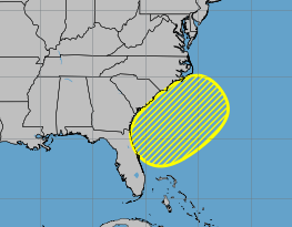
10AM Update 4 June 2025
The area off the southeast is down to a near 0% chance to develop as most of the energy has moved inland, and will prevent tropical development. However the rain will continue.
Beyond this nothing really on the horizon, a lot of noise on the Bay of Campeche and West Caribbean, but nothing solid. Anything that may get going is most likely to wind up in the eastern Pacific.
2PM Update 2 June 2025
The area off the east coast now has a 10% chance for development of a short-lived system.
Original Update
Today marks the start of the 2025 Atlantic Hurricane season, and also marks the 30th anniversary of this website, which started in 1995.
The season runs through November 30, 2025.
This year also marks the 20th anniversary of Hurricane , which changes a lot for this site and many others. As it started as TD#10 in the Open Atlantic, fell apart, then regenerated into , made landfall in South Florida as a category 1 hurricane, then grew extremely large and became a strong hurricane, only starting to weaken right at landfall, but it was too late, the surge momentum was already there and in impacted coastal Mississippi the hardest, and caused New Orleans to take years to recover.
This hurricane season is forecast to be average, but it only takes one system to change that opinion.
This year's names are:
Andrea AN-dree uh Lorenzo loh-REN-zoh
Barry BAIR-ree Melissa meh-LIH-suh
Chantal shahn-TAHL Nestor NES-tor
Dexter DEHK-ster Olga OAL-guh
Erin AIR-rin Pablo PAHB-lo
Fernand fair-NAHN Rebekah reh-BEH-kuh
Gabrielle ga-bree-ELL Sebastien se-BAS-tee-en
Humberto oom-BAIR-toh Tanya TAHN-yuh
Imelda ee-MEHL-dah Van van
Jerry JEHR-ee Wendy WEN-dee
Karen KAIR-ren
The only new name on the list is Dexter, which replaced Dorian. Dorian impacted the northern Bahamas greatly as a slow moving Category 5, gave Florida a scare, and eventually had a second landfall in the outer banks of North Carolina..
Starting out there's a very small chance than an area that could show sometime next week in the Caribbean, but it's not likely to amount all that much, and there is time to watch it. Only the model operational model shows it, but several ensembles from other models do. And it's more likely any energy winds up in the Eastern Pacific instead At this far out it's just something to watch, but the is known for creating storms out of nothing this time of year. Another small, weak and short lived area could form off the Carolinas and move out to sea in a week or so.
Edited by CFHC (Wed Jun 04 2025 10:29 AM)
|
cieldumort
Moderator

Reged:
Posts: 2499
Loc: Austin, Tx
|
|
I reckon Mike meant to say average by recent years' standards. After the beating many have had recently, the new normal almost starts to feel rather typical
NOAA itself officially predicts an above-average season when compared to the long-term Quote:
NOAA’s outlook for the 2025 Atlantic hurricane season, which goes from June 1 to November 30, predicts a 30% chance of a near-normal season, a 60% chance of an above-normal season, and a 10% chance of a below-normal season.
The agency is forecasting a range of 13 to 19 total named storms (winds of 39 mph or higher). Of those, 6-10 are forecast to become hurricanes (winds of 74 mph or higher), including 3-5 major hurricanes (category 3, 4 or 5; with winds of 111 mph or higher). NOAA has a 70% confidence in these ranges.
NOAA predicts above-normal 2025 Atlantic hurricane season
An overview of other professional agencies and universities as of the last day in May is also pointing to an above-average season, with the following numbers: 16 Storms, 8 Hurricanes and 4 Major Hurricanes. This is slightly above-average when compared to a longer-term (1991–2020 thirty year average) of 14 Names, 7 Hurricanes and 3 Majors, a time frame that also largely captures the "Active Phase" of the theorized Atlantic Multi-decadal Oscillation (AMO), which is believed to have started in 1995.
|
IsoFlame
Weather Analyst

Reged:
Posts: 377
Loc: One block off the Atlantic Oce...
|
|
In my recent memory (which is declining due to early onset!!) I don't recall the CAG being this active (potentially on both sides of the isthmus) this early in the season. Are there any analog years which might be compareable?
--------------------
CoCoRaHS Weather Observer (FL-VL-42) & Surf Forecaster: https://www.surf-station.com/north-florida-surf-forecast-3/
|
|


 Threaded


