cieldumort
Moderator

Reged:
Posts: 2708
Loc: Austin, Tx
|
|
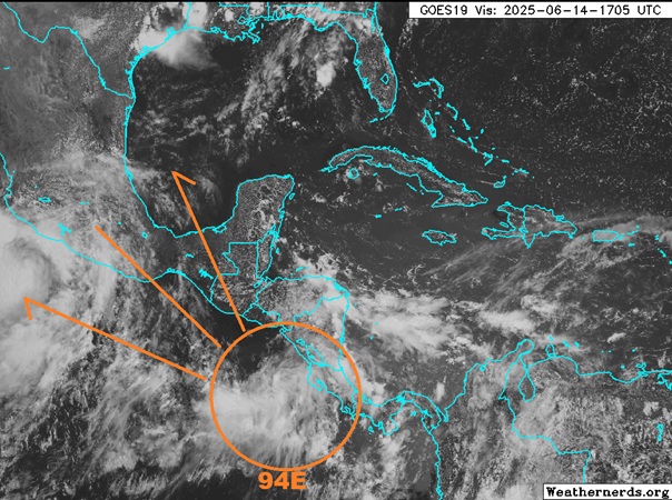
A robust tropical low developing in the extreme Eastern Pacific is poised to become next named tropical cyclone in that basin. Models have frequently, tho not unanimously nor consistently, advertised the potential for development in the southern Bay of Campeche next week and as we have drawn closer to this time frame, it appears that the feature almost all of those models' runs and/or some of their constituent ensemble members' runs have been latching on to, is for what is now Invest 94E in the east Pac and likely to become "Erick," to slide into the extreme western Gulf and/or old Mexico.
The chance for this system to become a named tropical storm in the Atlantic basin (specifically the western Gulf) is still questionable at best, but what is clearly becoming more possible is for an influx of deep tropical moisture and energy from this feature to enter south Texas, many parts of which are already very moist and still recovering from flooding that occurred this week.
Given the increasing chances for significant Texas impacts from either remnants of this presently East Pac tropical low or a bona fide numbered tropical cyclone from its crossover into the Gulf, we are starting a Lounge on this system at this time.
Presently has -0- probabilities up for Atlantic side development within the next 7 days, but this will change if current trends continue.
Edited by MikeC (Wed Jun 18 2025 01:57 PM)
|
cieldumort
Moderator
Reged:
Posts: 2708
Loc: Austin, Tx
|
|
|
cieldumort
Moderator
Reged:
Posts: 2708
Loc: Austin, Tx
|
|
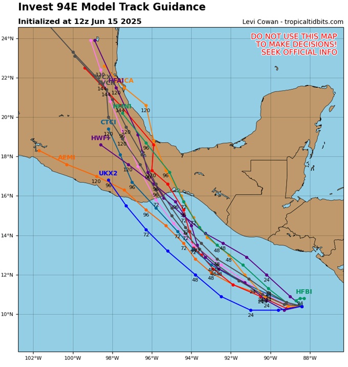
As of today's available 12Z runs, the consensus is that 94E (likely then Erick) takes a track more or less directly into Mexico, never producing an Atlantic side TC. However, given the expected location of a retrograding later next week, this would open the door for a moisture surge from the remnants to enter south Texas, and a flood concern for south Texas late next week regardless of BOC development remains.
|
MikeC
Admin
Reged:
Posts: 4835
Loc: Orlando, FL
|
|
94E has a shot at intensifying really quickly, but it'll likely stay over the mainland.
|
cieldumort
Moderator
Reged:
Posts: 2708
Loc: Austin, Tx
|
|
Now that models have seen where 94E actually developed as well as gotten a better handle on its environment, there is not a single example left of a good model suggesting it crosses over into the Bay of Campeche. In fact, the could be weaker and/or more diffuse than expected, aiding in what is now East Pac FIVE/ERICK to track even further west, with more time over water to become what could be the first East Pac Major of the year.
Also now that models no longer have this potential crossover to latch on to, virtually none of them show anything brewing in the W ATL for the foreseeable future.
|
MikeC
Admin
Reged:
Posts: 4835
Loc: Orlando, FL
|
|
94E is now Tropical Storm Erick, and forecast to be a category 2 at landfall just east of Acapulco, Mexico Thursday morning. This is close to the same area where Otis hit in 2023, which went from a Tropical Storm to category 5 hurricane in less than 24 hours.
Nhc discussion on intensity:
The environment appears ideal for rapid strengthening. Vertical
shear is expected to be very low, with the cyclone moving over
waters of around 29 degrees Celsius and within a moist
mid-level environment of around 80 percent relative humidity.
As a result of these conditions, Rapid intensification (RI) indices
are rather high, particular for the 36- and 48-hour periods. The
NHC intensity forecast explicitly shows RI occurring while Erick
approaches the coast of southern Mexico, with a 48-hour intensity
just below major hurricane strength. Despite this increase in the
forecast intensity, there are still a few models (including the
normally skillful HCCA aid) that show Erick reaching major
hurricane strength, and additional upward adjustments in the
forecast could be required later today.
|
MikeC
Admin
Reged:
Posts: 4835
Loc: Orlando, FL
|
|
Now hurricane Erick with 100mph winds, and the forecast takes it to Major before landfall. And may get stronger than forecast.
Dvorak numbers are high too (4.9 official, 6.7 raw) which may make it a major by the next advisory.
|
MikeC
Admin
Reged:
Posts: 4835
Loc: Orlando, FL
|
|
5.7 adjusted, 7.1 raw now (Cat 3 on satellite estimates) New advisory in about an hour.
|
cieldumort
Moderator
Reged:
Posts: 2708
Loc: Austin, Tx
|
|
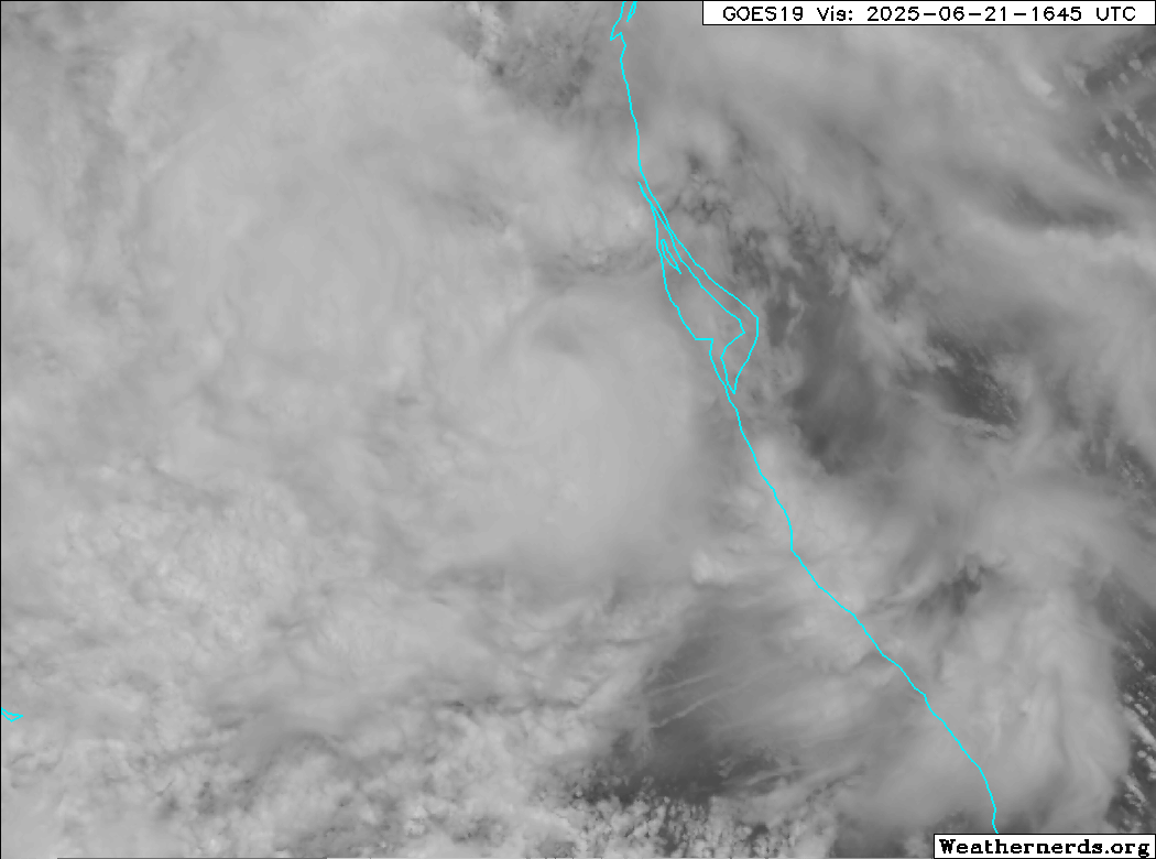
Remnants of Erick did finally make it towards and partially into the extreme western Gulf, but not nearly intact enough nor over water enough to warrant an Invest tag. The reconstituted system, which is more of a blend of some of Erick's moisture, mid/upper level voticity and preexisting trofiness in the region, has produced very heavy rains over eastern Mexico.
|


 Threaded


