MikeC
Admin
Reged:
Posts: 4811
Loc: Orlando, FL
|
|
4AM EDT Update 7 July 2025
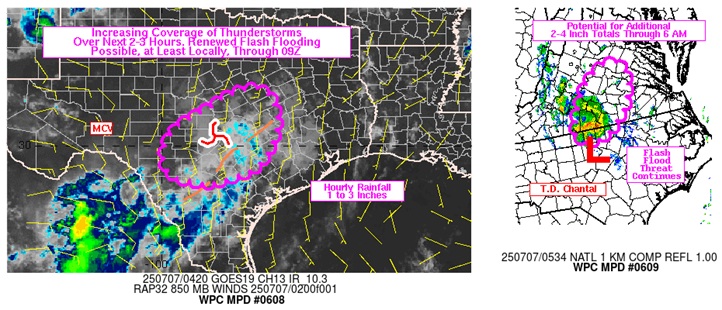
Above: NWS WPC Mesoscale Precipitation Discussions 608 and 609, covering both Barry's remnants in Texas and T.D. Chantal in North Carolina
Rem Chantal has joined the flood club and handily exceeded catastrophic once-in-1,000 year rainfall totals for that part of North Carolina around Chapel Hill, Mebane, Pittsboro and Durham.
Both Chantal and Barry, "just" tropical storms and even more so, now more or less remnants of their former selves, not-so-gently serve as reminders that the Saffir-Simpson scale, while useful to a point, fails miserably to capture and inform of the full impacts from these storms.
As of 4AM July 7, 2025, the death toll from the devastating floods in Texas has risen to at least 82, with perhaps another 40 souls still missing.
Ciel
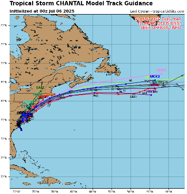
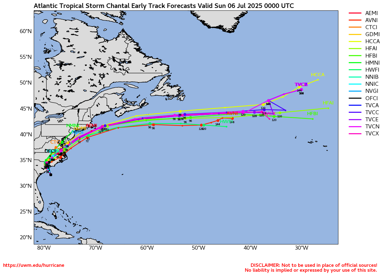
5AM EDT Update 6 July 2025
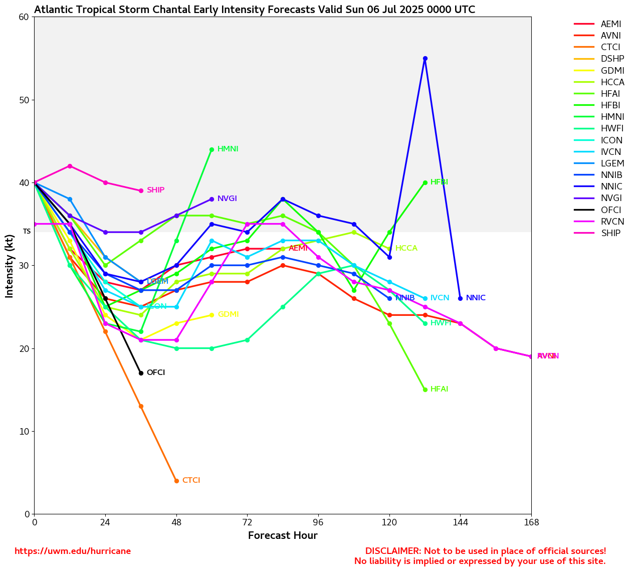
Tropical Storm Chantal continued intensifying up to landfall and may have been at or above 60 MPH in the end. Chantal is now pushing into the Carolinas with heavy to very heavy rain, strong tropical storm wind, isolated spinup tornadoes and flooding potential.
Meanwhile, the remnant mid-level circulation of former Tropical Storm Barry, tracked for days as an MCV, continues to tap into Barry-enhanced precipitable water contents literally at the climatological maximum for this time of year in some places over the past few days, resulting in flash flooding that has claimed at least 43 lives, confirmed, and counting. One wonders whether or not the name "Barry" should be retired.
Ciel
12PM EDT Update 5 July 2025
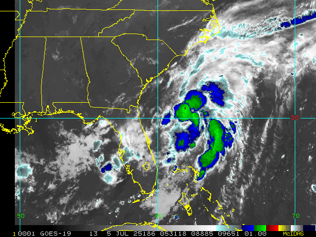
This morning TD 3 upgraded to Tropical Storm Chantal. Recon is back in the cyclone now and finding it getting a little stronger still, so we may be seeing a run at a mid-range tropical storm before coming ashore, assuming it does come ashore. There is an outside chance that the center keeps hopping into the deeper convection that is still in its eastern side so much so that it never makes an official landfall. Also, the longer Chantal stays over water, the better the odds it has of gaining strength.
Elsewhere, the remnant circulation and extremely high moisture levels from former Tropical Storm Barry continues to inundate and devastate much of central Texas where the death toll is now up to 27 confirmed, with many more still missing.
Ciel
5PM EDT Update 4 July 2025
The largely expected formation of Tropical Depression Three off the southeast coast this week has verified and has started advisories on what is expected to become Tropical Storm Chantal by tomorrow afternoon and come ashore in South Carolina by Sunday morning. Given this, a Tropical Storm Watch has been issued from Edisto Beach, South Carolina to Little River Inlet, South Carolina.
Noteworthy that we have had three back-to-back Invests in a row, our first three, become Tropical Cyclones.
Ciel
1PM EDT Update 4 July 2025
The first of several scheduled recon missions into Invest 92L is currently en route to check out this area of low pressure off the southeast coast that already looks suspiciously like a verifiable tropical depression or storm. Interests along the southeast coast may want to begin paying closer attention as holiday weekend impacts are becoming likely.
Elsewhere, remnants of former Tropical Storm Barry, especially its moisture and moisture drawn up from the gulf from its circulation, has helped feed the development of a quasi "landphoon" over central Texas, with multiple flooding fatalities and missing people reported.
Ciel
1AM Update 4 July 2025
The much advertised surface trof now located off the southeast coast and east of the state of Florida has been Invest tagged, 92L, and recon is tentatively tasked with flying into it later today, July 4, if necessary.
This disturbance is most likely going to stay primarily a rain-maker and holiday nuisance regardless of classification status, but there is a chance of something more as it tracks ultimately north to northeast, off, along or into the southeast coast.
We do have an active Forecast Lounge on 92L where we have been going a little deeper into model runs: Chantal Forecast Lounge
Ciel
Original Update
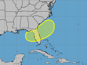
Barry has made landfall and dissipated, so now the attention moves to the 20% area that stretches from the northeast gulf over Florida into the Southeastern Atlantic.
The primary impact of this area, which is a front that likely will stall out over the same area, along with next to steering currents and high water temperatures gives a ripe area for something to possibly develop. However, this something may try to form over land, and if it does, it won't become anything tropical. This is the most likely scenario. It does mean potential for a lot of rain all week, especially toward the end of the week, mostly along the north west coast of Florida and the panhandle, but also reaching across the peninsula, into southern Georgia, and extreme southeastern North and South Carolina. Meaning if you are in those areas, the likelihood of a washout for independence day is on the high side.
As for development, a lot depends on where something decides to form, if at all. Because of how broad the area is models aren't very good at picking up exactly where something may form. Some favor it leaning toward the Gulf side, some off the southeastern coast, and others split the difference over land, which translates into no tropical development.
To reflect this, tthe image below represents locations various models have picked up on.
Image source Google Deepmind
Anything that shows up in the main line models means it's picking one of these and speculating on what happens. The spread means we'll have to watch it. Even if something forms, the likelihood of it becoming strong are slim, but if anything does it is imperative to keep watch to see how it drifts around in a low steering environment. In short, it needs to be watched all week in case it does consolidate, but most likely won't do much other than
rain.
Any Gulf area developing would be the most impactful, best case would be something offshore the southeast as it would likely wind up moving out to sea from there, unlikely to still be together if it got anywhere close to Bermuda.
As it stands now, the most likely outcome is no tropical development, with a lot of off/on rain.
Event Links
Long term radar recording of Florida for the entire length of the area
Edited by cieldumort (Mon Jul 07 2025 08:02 AM)
|
CFHC

Reged:
Posts: 197
Loc: East Central Florida
|
|
Satellite currently, front not down, lots of energy over the northeast gulf, some convection near the southwestern Bahamas associated with an upper leve low that actually is shearing the gulf, and the front isn't down until a few days from now. Nothing really organizing yet.
Edited by MikeC (Tue Jul 01 2025 02:41 AM)
|
MikeC
Admin
Reged:
Posts: 4811
Loc: Orlando, FL
|
|
Area is up to 30% this morning, with development more favored off the southeast coast than the Gulf, but anywhere in yellow (and maybe a bit east of the yellow area) is suspect.
|
MikeC
Admin
Reged:
Posts: 4811
Loc: Orlando, FL
|
|
The area has a 40% chance to develop later this week, unlikely to be strong, but could be tropical (or subtropical).
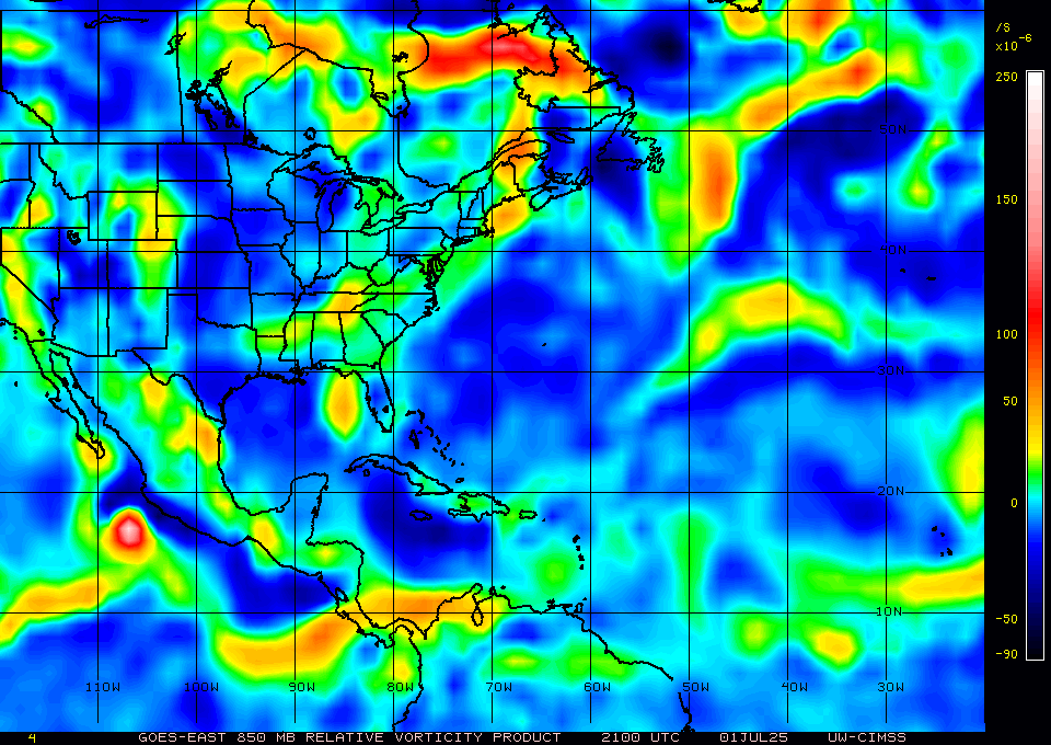
Some vorticity in the gulf, front is over Alabama through Virginia right now, won't really reach Florida until Thursday, but the energy is there, Upper level low to the east is fading.
|
CFHC
Reged:
Posts: 197
Loc: East Central Florida
|
|
Surface observations show a circulation east of Florida with 92L, recon is scheduled to go out later today.
|
|


 Threaded


