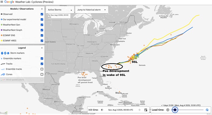
The area of low pressure originating from a frontal zone we have been watching closely today has now been Invest tagged, 95L, and considering its proximity to land and especially as several models' runs have suggested a spawn left in the wake of its exit that has an even better chance to hook back towards the US, we are starting a Lounge on what for now will only be for 95L, but could also be merged into a two-fer, should 95L indeed perform such a split.
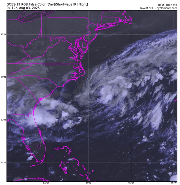
As of 0z/8/3/25, the low pressure system still appeared a bit entangled with its parent front, but had slowly been adding on some weak banding features and a few blowups of deeper convection. Maximum sustained winds at time of Invest tagging were roughly 30 knots.
Invest 95L
As of 00:00 UTC Aug 03, 2025:
Location: 32.8°N 74.6°W
Maximum Winds: 30 kt Gusts: N/A
Minimum Central Pressure: 1012 mb
Radius of Maximum wind: 50 nm
Invest 95L has become our next named storm, Dexter, as of 8/3/25/11pm, and the title has been updated accordingly
Ciel
Several more models' runs than just those above also tease the possibility of a new storm developing in the wake of 95L that has a much better chance of tracking towards the US
Tropical Storm #Dexter has formed off of the North Carolina coast - the 4th Atlantic named storm of the 2025 #hurricane season. On average, the 4th Atlantic named storm forms on 15 August. No hurricanes have formed in the Atlantic yet this year. Average 1st hurricane is 11 August pic.twitter.com/xIhiECgYFD
Dexter may have gotten stronger than advertised overnight, but there is not much in the way of nearby buoys, ships, etc., and no recon whatsoever. The cyclone is on a bit of a downtrend this morning in response to some moderate shear, but may have a few shots of intensification before undergoing either extratropical transition or dissipation in a few days.
The "spawn" or "sibling" of Dexter modeled by several runs of several different models is looking even less uncertain today, with a couple all but dropping the expectation, with others pushing off any sort of development out another few days (itself a trend that sometimes signals things aren't looking so good for development). Those recent runs that do cook something up have it come into the southeastern US weaker than most prior runs. The 202508040z EPS implied development odds are roughly 40% within 4 days, but also unanimously keep anything that forms weak (although "weak" does not mean without potential impacts, esp water/flood risk).


 Threaded