cieldumort
Moderator

Reged:
Posts: 2677
Loc: Austin, Tx
|
|
3:00PM EDT 23 August 2025 Update
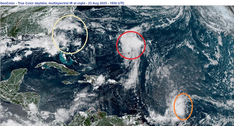
Advisories are "almost 100%" coming at any time today for Invest 90L as it tracks north and closer to the island of Bermuda. For now, a direct hit remains a lower risk than it seemed this time yesterday.
Perhaps of greater concern, models have started to wake up on Invest 99L, with a few operational runs and several ensembles now developing it in the Caribbean. This would be a landlocked tropical cyclone in the western Atlantic should this occur.
NHC has just tasked several missions to investigate 99L later this weekend as it approaches and passes through the Windwards. They may find it a developing tropical cyclone by then, and it is not inconceivable that PTC Advisories could go out should current trends continue, despite the present very low 20% odds. Models have consistently underbid this system. Tenacious disturbances are always worthy of paying extra attention to.
Finally, and already close to home, we are monitoring the potential for a hybrid system to develop off the southeast coast late this weekend into early next week.
Ciel
8:00AM EDT 23 August 2025 Update
Watches could be going up for Bermuda later today with Invest 90L, now very likely to become our next named storm. Modeling favors a track east of the island, but impacts would be in the cards regardless of a direct hit or not. The next name on the list this year is Fernand.
We are also still monitoring Invest 99L approaching the eastern Caribbean. This disturbance has already been what many would allow to be considered a bona fide tropical storm, but is presently dealing with some moderate shear. As it nears the Windwards later this weekend, shear could relax, allowing it another chance to organize, and interests in and near the eastern Caribbean may want to stay alert for any changes in its strength. Locally heavy rain and gusty conditions seem to be on tap in spots at a minimum as it moves through the Windwards Sunday and Monday.
Ciel
Original Update
Behind (formerly Cat 5) Hurricane Erin, the Atlantic basin is still primed for an active season, overall. While social mediarologists love to hype the extremes ("NO STORMS THIS YEAR!") ("WORST HURRICANE EVER THIS THIS!") for clicks, Flhurricane has and will always continue to play it straight.
2025 is still more favored than not to be above-average in terms of Names, Hurricanes, Majors and ACE. While not any guarantee, this simply means that the dice are arguably a little weighted to the bigger digits.
Near-term and closer to home:
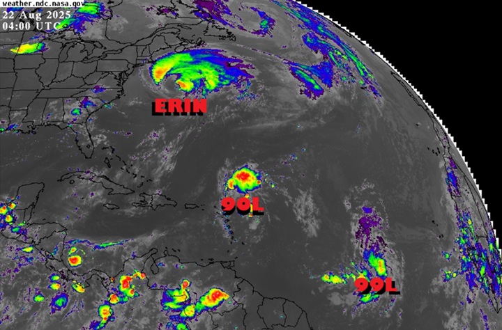
Invest 99L probably already qualifies as a Tropical Storm. Awaiting the official decision desk, but suffice it to say, we need to watch this one closer either way, as it starts at a much lower latitude than many others this season.
Invest 90L has been getting more press as the better candidate, but that only has been the case if 99L didn't pull it off soon enough. Both are more likely than not to get named. 99L could directly threaten the Caribbean. 90L could make a direct strike on Bermuda, potentially even as a Major. Time to take some initial preps if in these regions.
Deep-Dive Model Discussion Lounges
99L Forecast Lounge (Central Tropical Atlantic)
90L Forecast Lounge (Rounding Leewards)
Hurricane Erin Forecast Lounge
Error reading wiki page. View on wiki
Error reading wiki page. View on wiki
Error reading wiki page. View on wiki
Error reading wiki page. View on wiki
Error reading wiki page. View on wiki
Error reading wiki page. View on wiki
Edited by MikeC (Sat Aug 23 2025 05:59 PM)
|
cieldumort
Moderator
Reged:
Posts: 2677
Loc: Austin, Tx
|
|
Product: Air Force Vortex Message (URNT12 KNHC)
Transmitted: 23rd day of the month at 20:13Z
Agency: United States Air Force
Aircraft: Lockheed WC-130J Hercules with reg. number AF98-5308
Mission Purpose: Investigate fourth suspect area (flight in the North Atlantic basin)
Mission Number: 1
Observation Number: 14
A. Time of Center Fix: 23rd day of the month at 19:29:50Z
B. Center Fix Coordinates: 26.81N 61.46W
B. Center Fix Location: 429 statute miles (690 km) to the SSE (152°) from Hamilton, Bermuda (U.K.).
C. Minimum Height at Standard Level: 773m (2,536ft) at 925mb
D. Minimum Sea Level Pressure: 1010mb (29.83 inHg) - Extrapolated
E. Dropsonde Surface Wind at Center (Undecoded): NA
F. Eye Character: Not Available
G. Eye Shape: Not Available
H. Estimated (by SFMR or visually) Maximum Surface Wind Inbound: Not Available
I. Location & Time of the Estimated Maximum Surface Wind Inbound (Undecoded): NA
J. Maximum Flight Level Wind Inbound: From 75° at 21kts (From the ENE at 24.2mph)
K. Location & Time of the Maximum Flight Level Wind Inbound: 6 nautical miles to the NNW (348°) of center fix at 19:28:00Z
L. Estimated (by SFMR or visually) Maximum Surface Wind Outbound: 0kts (0.0mph)
M. Location & Time of the Estimated Maximum Surface Wind Outbound: 0 nautical miles to the N (360°) of center fix at 0:00:00Z
N. Maximum Flight Level Wind Outbound: From 241° at 38kts (From the WSW at 43.7mph)
O. Location & Time of the Maximum Flight Level Wind Outbound: 17 nautical miles (20 statute miles) to the SE (138°) of center fix at 19:35:30Z
P. Maximum Flight Level Temp & Pressure Altitude Outside Eye: 20°C (68°F) at a pressure alt. of 762m (2,500ft)
Q. Maximum Flight Level Temp & Pressure Altitude Inside Eye: 20°C (68°F) at a pressure alt. of 766m (2,513ft)
R. Dewpoint Temp (collected at same location as temp inside eye): 20°C (68°F)
R. Sea Surface Temp (collected at same location as temp inside eye): Not Available
S. Fix Determined By: Penetration, Radar, Wind, Pressure and Temperature
S. Fix Level: 925mb
T. Navigational Fix Accuracy: 0.02 nautical miles
T. Meteorological Accuracy: 1 nautical mile
Remarks Section:
Maximum Flight Level Wind: 38kts (~ 43.7mph) which was observed 17 nautical miles (20 statute miles) to the SE (138°) from the flight level center at 19:35:30Z
Sea Level Pressure Extrapolation From: 925mb
|
MikeC
Admin
Reged:
Posts: 4830
Loc: Orlando, FL
|
|
Added two different radar recordings for 99L on here https://flhurricane.com/cyclone/animationlist.php
|
cieldumort
Moderator
Reged:
Posts: 2677
Loc: Austin, Tx
|
|
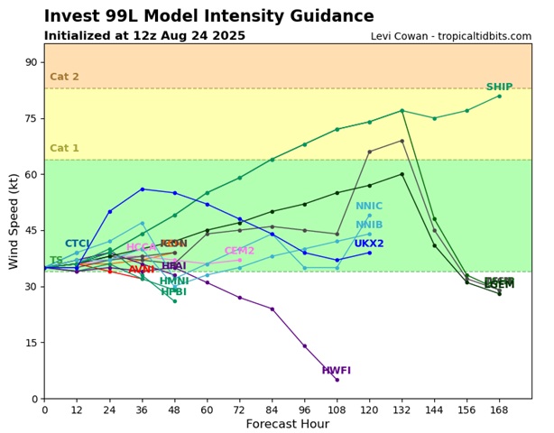
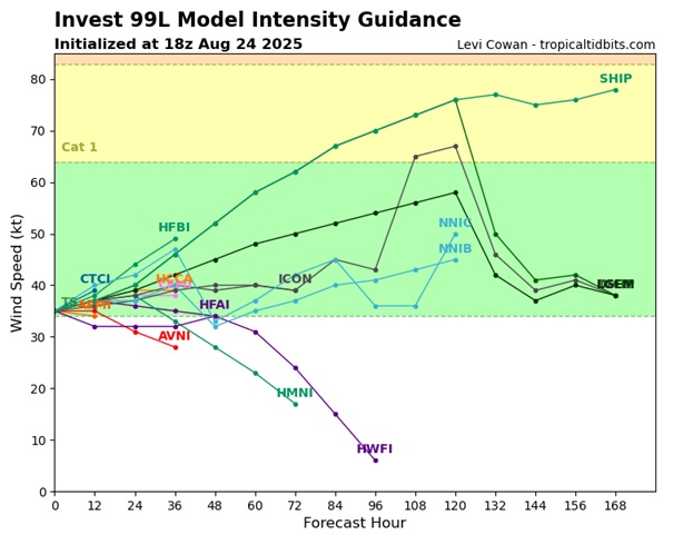
Today's 12Z and 18Z intensity guidance suggests that should 99L survive, which presently looks to be about a coin toss but decreasing, a majority calls for steady-state to even gradual strengthening for several days. Currently, 99L is estimated to have 35 knot max sustained winds at the surface based on scatterometer data and classifications. Recon so far marginally supports this estimated max sustained wind as well.
|
|


 Threaded


