cieldumort
Moderator

Reged:
Posts: 2738
Loc: Austin, Tx
|
|
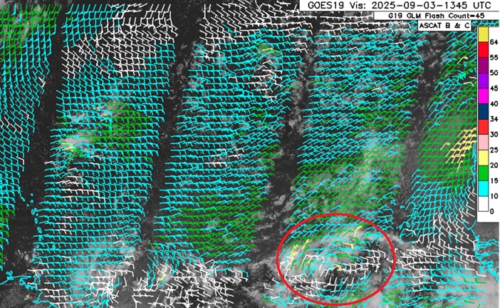
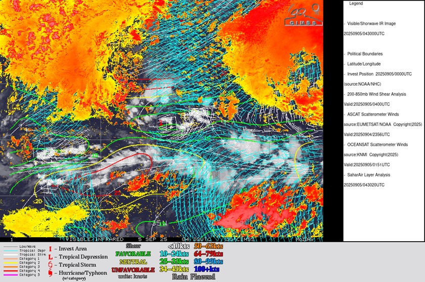
Above: Area of Interest East Trop ATL Wave Visible w/ASCAT overlay cr: Weathernerds.org
A stout tropical wave in the eastern Tropical Atlantic, not yet mature enough just yet for an Invest tag but with strong and nearly unanimous model support for development, continues to march west or west-northwest and given the increasing odds of formation with potential threats to land downstream, we are starting a lounge on this wave at this time (Invest tag likely at any time and will update accordingly).
The wave we have been watching has been Invest tagged this morning of Sep 4, 91L, and the title has been updated accordingly.
2025-09-04 12Z 12.1N 33.5W 20 KTS
Ciel
Edited by cieldumort (Thu Sep 04 2025 10:46 AM)
|
CFHC

Reged:
Posts: 211
Loc: East Central Florida
|
|
12z icon is north of the islands, so is the Canadaian and , however gets pulled west by an ULL this run and eventually makes landfall around Edisto Beach in South Carolina, putting Charleston in the right front quadrant of the storm (worst surge).
GFS is a massive shift left from earlier runs, so It'll be important to monitor for changes or if it flips back later.
Confidence in forecast is already pretty low with the spread in ensembles between the google, euro, and sets. Most likely is near/east of the Caribbean islands and a recruve still, but confidence in that is dropping. Needs a few more model runs an invest certainty to help. Euro is really weak on the 12Z run, but does get into the Caribbean. An upper level low and are the major features stirring it up. There is likely going to be a lot of run to run variance in the models for a while. For exaple the 12Z ensembles still all recurve east of the islands despite the operational not doing so.
|
MikeC
Admin
Reged:
Posts: 4835
Loc: Orlando, FL
|
|
Overnight models are very much split between the ensemble and operational camps, showcasing a lot of uncertainty in the future both in track and intensity. The 6z shows the system making it north of the Caribbean islands, but getting caught up in the westerly flow of an ULL shunting it west over the Bahamas, start to recurve east of Florida and eventually making landfall around the SC/NC border as a cat 3/4 hurricane. The 0z Euro makes it east of Florida at the end of the run.
However, the 0z Ensembles all recurve and approach Bermuda, although some do go through the northern islands. None of the ensembles make it to the Bahamas or united states. The same goes for the Euro ensembles, except many more go over the islands.
The Leeward islands must watch this system, and Bermuda, the Bahamas and the SE Us will want to monitor the progression of the system. Still most likely it gets close/near the islands and recrrves threatening Bermuda, but it's a rather weak confidence compared to Erin. Other areas like the Bahamas and eastern US will need to monitor as well.
 ' '
|
cieldumort
Moderator
Reged:
Posts: 2738
Loc: Austin, Tx
|
|
Now that we have an Invest tag on a more coherent system for models to latch on to, forecasts should start to improve some.
Here is the most recent (today's 0z and 06Z) ensemble heat maps courtesy Tomer Burg (@burgwx) for 91L
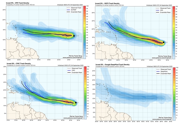
Above: 0z-06z Ensemble heat maps from , , and DeepMind
"Probability of center location within 150-km" (0-100%)
For as impressive as DeepMind has been at times, with regard to this run on 91L, it looks surprisingly uncertain.
|
IsoFlame
Weather Analyst

Reged:
Posts: 414
Loc: One block off the Atlantic Oce...
|
|
Quote:
For as impressive as DeepMind has been at times, with regard to this run on 91L, it looks surprisingly uncertain.
Just a gut feeling... I believe 91L will end up being a "sacrificial system", not amounting to much more than a tropical storm at best, priming the central tropical Atlantic MDR (and the untaped, seasonally receptive western Caribbean/GOMEX/SW Atlantic) for what will come later in September and in early October.
--------------------
CoCoRaHS Weather Observer (FL-VL-42) & Surf Forecaster: https://www.surf-station.com/north-florida-surf-forecast-3/
|
MikeC
Admin
Reged:
Posts: 4835
Loc: Orlando, FL
|
|
12Z euro is also suggesting not much development from 91L. Albeit it's a complex setup that could go the other way. The euro ai has avoided developing it as well. UKMet doesn't like this one. So it may not amount to much, early. Dry air issues and small size also mix it up some as well as a potential double vortex in a few days on some of the models. However, watching the satellite in the near term will help decide which direction it may go.
|
IsoFlame
Weather Analyst
Reged:
Posts: 414
Loc: One block off the Atlantic Oce...
|
|
12z tracks 91L through the Bahamas as a mid-grade tropical storm, then into S. Florida while weakening. Quite a change from the previous run.
--------------------
CoCoRaHS Weather Observer (FL-VL-42) & Surf Forecaster: https://www.surf-station.com/north-florida-surf-forecast-3/
|
MikeC
Admin
Reged:
Posts: 4835
Loc: Orlando, FL
|
|
18z back to the near/over islands then toward Bermuda, which still remains the most likely scenario. Although there is a lot of mixup regarding intensity and exact positioning of the upper level low as well as the vortex west of 91L
|
cieldumort
Moderator
Reged:
Posts: 2738
Loc: Austin, Tx
|
|
The latest run of the is probably going to get a lot of unwarranted airplay on social media because it shows a direct Florida hit. To put things into better perspective, is possibly the most bullish Global of all on 91L's prospects, with others, including "King EURO," and the newer AI versions of the EURO, far less so, with several runs of the Euros showing no development at all, or rapid decay.
91L is not in the most ideal initial state, or environment, for development. Likely better than the Euro would suggest, but also maybe less than the .
A look at the past nine runs of the show that while this model consistently develops the Invest, with some runs cooking up a very powerful Major, the forecast tracks and intensities are often vastly apart from one another. I think we will need to first get some good recon data out of this system before putting much stock in its track and intensity forecasts beyond 3 days (72 hours)
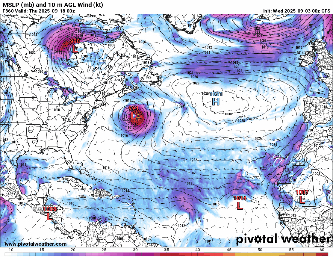
Above: Past nine runs of the Operational showing wildly varied locations and intensities of 91L
NHC odds of development at 90% within 7 days seem reasonable. This number is probably accurate for within 72 hours at this point, and looking ahead at the next 72 hours it seems more likely than not to me that 91L will be named during this time. The next name on the list is Gabrielle.
|
cieldumort
Moderator
Reged:
Posts: 2738
Loc: Austin, Tx
|
|
Shear, ASCAT and SAL analysis puts 91L in a narrow but viable sweet spot for development over the next few days at least, with a surface low that is probably closed but still elongated at present, and which is also separated fairly south of the deep convection and mid-level circulation of the parent wave. Initial development thus could continue to be gradual, but conditions are conducive enough such that if TC Genesis occurs, which looks likely, Rapid Intensification may be possible before it reaches the longitude of the Antilles.
|
MikeC
Admin
Reged:
Posts: 4835
Loc: Orlando, FL
|
|
Competing vortexes and the are a massive dampening feature on 91L, I..e the possibility is there that it never develops before (or potentially after) the islands. Which needs to be pointed out, especially with ensembles starting to drop out, and the overnight euro not developing it at all. The area southwest of 91L is part of that, but the overal conditions and dry air around it make development not a guarantee. However the islands needs to monitor and hope the weaker trends continue.
The Mid Levels and low levels are not aligned, and not sure there's much at the low levels right now (similar to how 99L never really consolidated). It'll be a while before recon is able to get in there, so it'll just be satellite monitoring now. Until the mid level area southwest quits moving along with it it probably won't be able to accomplish that at all the levels it needs and won't develop.
So it's a bit of a wait and see. There's a pretty high bar for it to develop, and it's not there right now. Models are going to vary a lot until some of this is settled, but I'd bet against it developing until it's clear at all levels there's something still not stuck in the monsoonal flow or mixed in with the other area southwest.
On this chart you see 91L at the 850mb level, and a lobe southwest of it attached to another mid level vorticity, you want to see this detach, or the other area go away before any real development can occur, if it doesn't it'l going to go into the islands weak or as an open wave, as the LLC won't be able to align with either. Even if it does, position of the may weaken it later, it just doesn't have great conditions right now.
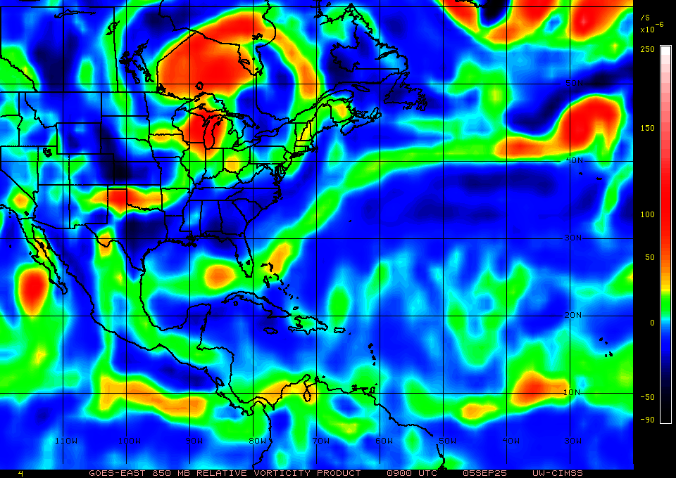
Larger WV Satellite shows the issues around it also:
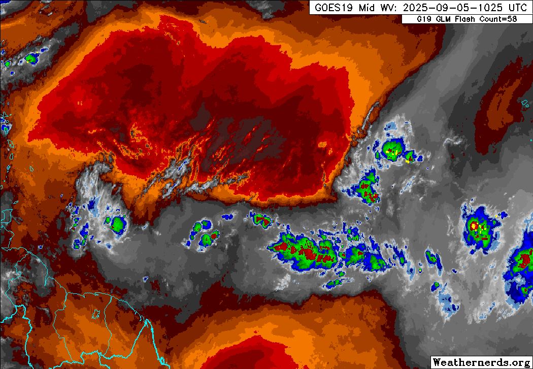
I don't expect development today, and the may drop chances for development later if the mlc issues remain, it's a monitor the satellite/environment over the next day or few time. Still an incredibly difficult setup to determine which way it goes.
Models are all over the map, 6z recurves out to sea after touching the NE caribbean islands, after 0z moved it all the way to Florida through the Caribbean. Ensembles like the google one, only have 1 developing it. ensembles have dropped a lot of support for it, although those tend to go into the Caribbean. Most of Euro ensembles that develop it, also curve it near /over the islands. UKMet does not develop it either.
|
cieldumort
Moderator
Reged:
Posts: 2738
Loc: Austin, Tx
|
|
With many hours of daylight providing a much better look at 91L, the environment for development is probably even more difficult for it to develop than things looked overnight. Most waves out in the Tropical Atlantic can't quite seem to catch a break this season.
Unsurprisingly, several models have now dropped development altogether, and as noted above, the number of bullish ensemble members have also been decreasing. While holds at 60% by Sunday and 90% within 7 days, realistically we may see this get lowered to something like 50% by Sunday and 70% within 7 days. I'm now in the 50% within 48 and 70% within 7 days camp myself, and going lower if current trends continue into the weekend.
That said, a coin toss within 48 hours is still worthy of tracking for the Caribbean, especially considering that an initially weaker system would probably favor a southerly track with less odds of out-to-sea.
|
cieldumort
Moderator
Reged:
Posts: 2738
Loc: Austin, Tx
|
|
Remains of 91L still hanging around, now north of Hispaniola and Puerto Rico. Practically zero model support, and about the only thing of any interest in the Western Atlantic on the climatological peak of a season, September 10th. Wild.
|


 Threaded


