Current Radar or Satellite Image

Flhurricane.com - Central Florida Hurricane Center - Tracking Storms since 199530 Years of Hurricanes Without the Hype - Since 1995


Both basins now potentially threatening: Pacific #HurricaneKiko drawing closer to Hawaii #HIWX Atlantic: #91L drawing closer to Caribbean and #HurricaneLorena impacting Baja and SWUS #AZWX
Days since last H. Landfall - US: Any 330 (Milton) , Major: 330 (Milton) Florida - Any: 330 (Milton) Major: 330 (Milton)


General Discussion >> 2025 Forecast Lounge

Pages: 1
cieldumort
Moderator


Reged:
Posts: 2601
Loc: Austin, Tx
Hurricane Kiko Lounge (Hawaii)
      #115835 - Wed Sep 03 2025 01:41 PM


Above: Hurricane Kiko in the E Pac 9-3-25-1710z

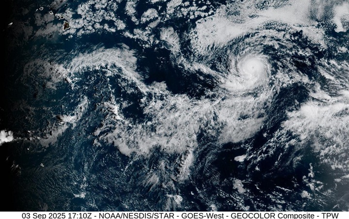
Models are coalescing around a close to direct approach of Pacific Hurricane Kiko on the Hawaiian Islands, and as such, we are now starting a Lounge on this powerful tropical cyclone.

Hurricane Kiko is set to travel across slightly cooler waters on approach to or near Hawaii and is likely to undergo some weakening. However, because of the topography of the islands, impacts, potentially serious, are a concern.


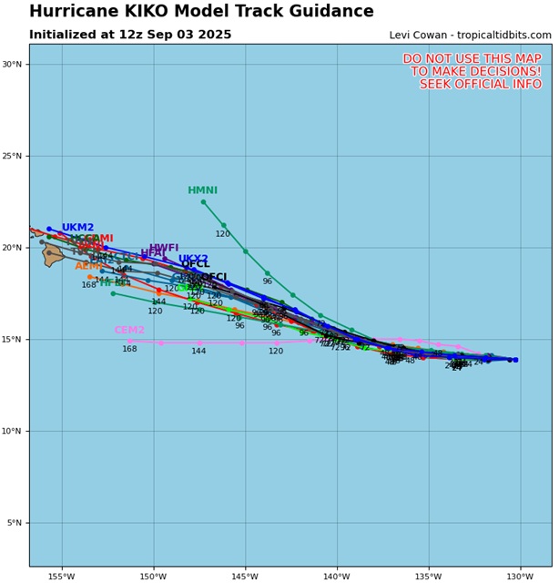
Above: 9/3/25/12z Track guidance of Globals and Hurricane models. Image cr. Tropical Tidbits


Post Extras: Print Post   Remind Me!   Notify Moderator  
Pages: 1


Extra information
0 registered and 0 anonymous users are browsing this forum.

Moderator:  

Print Topic

Forum Permissions
      You cannot start new topics
      You cannot reply to topics
      HTML is disabled
      UBBCode is enabled

Rating:
Topic views: 268

Rate this topic

Jump to

Note: This is NOT an official page. It is run by weather hobbyists and should not be used as a replacement for official sources. 
CFHC's main servers are currently located at
Hostdime.com in Orlando, FL.
Image Server Network thanks to Mike Potts and Amazon Web Services. If you have static file hosting space that allows dns aliasing contact us to help out! Some Maps Provided by:
Great thanks to all who donated and everyone who uses the site as well. Site designed for 800x600+ resolution
When in doubt, take the word of the National Hurricane Center