MikeC
Admin
Reged:
Posts: 4835
Loc: Orlando, FL
|
|
18z stalls it offshore of South Carolina and it never makes landfall, which is valid case, need to watch it closely either way since it's somewhat borderline if it does or not, but it's some good news. It matches the forecast.
|
MikeC
Admin
Reged:
Posts: 4835
Loc: Orlando, FL
|
|
0z gets a little closer to florida, but is slower, resulting it stalling even further away from south carolina. It's looking more likely that it won't make a direct us landfall tonight, the Bahamas will need to watch, however as this setup is still prone to change.
|
MikeC
Admin
Reged:
Posts: 4835
Loc: Orlando, FL
|
|
Most operational models are taking it out to sea now after stalling out north of the Bahamas, a few hurricane models still show landfall. Ensembles are pretty split on both (AI and others). The general idea to watch for is how far north and west the system develops and how quickly it moves. In this situation anything forming further north than the models show is more likely to have a landfall. Anything south, or slower movement is more likely to stall and stay out to sea beyond the Bahamas. It's still a very murky picture, and the track cone at the end reflects that. As it passes, Florida probably won't see much from it, perhaps a few outer bands along the coast, but we're mostly on the weaker side of the system.
As of this morning it looks more likely than not that there will be no US landfall, however, still way too much uncertainty to be positive of that. Also later in the week it could wind up back closer to land depending on the binary interaction with Humberto. I doubt we'll be able to stop watching this for a while. Bermuda will have to regardless.
|
MikeC
Admin
Reged:
Posts: 4835
Loc: Orlando, FL
|
|
Still very mixed models on nine
GFS cuts east around st. augustine,
18z Euro stalls it offshore
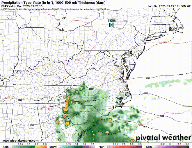
Many of the hurricane models make landfall or stall just offshore
Ensembles Mixed, but majority push it east, but it's barely a majority.
|
MikeC
Admin
Reged:
Posts: 4835
Loc: Orlando, FL
|
|
Slow motion allowed Humberto's latitude to catch up and the window for the SE is closing, so it appears Nine will make it up east of Florida around Central Florida and head out to sea, like the track shows. Bermuda should watch down the road, though. (And also Humberto)
|
cieldumort
Moderator

Reged:
Posts: 2706
Loc: Austin, Tx
|
|
While very good news for the southeastern US that trends favor a track out to sea with NINE, this is not necessarily the case for Bermuda.
Looking at the below loop is instructive.
From left to right:
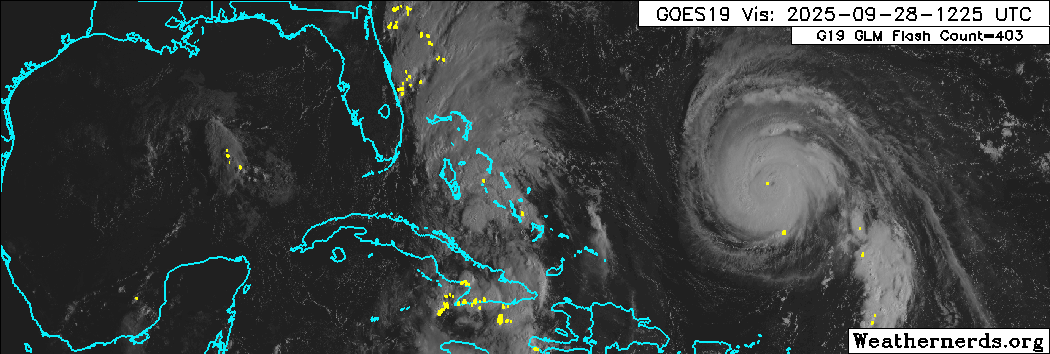
Gulf: Weak low pressure expected to wash out. Bahamas: Barely a T.D, Nine, struggling to strengthen. SW Atlantic: Major Hurricane Humberto
Another way of viewing this from left to right: Gulf: Hostile for development. Bahamas Barely conducive for development. SW Atlantic: Very favorable for development.
Should NINE track out into the SW Atlantic as forecast, which looks likely, it will probably be finding an environment very favorable for development, and on its forecast track, may threaten Bermuda with severe impacts. Worth keeping an eye on.
|
MichaelA
Weather Analyst

Reged:
Posts: 956
Loc: Pinellas Park, FL
|
|
I find it interesting that the NAVGEM was an early outlier in showing the hard right turn several days ago, and being consistent. The then began to follow suit, followed by the , then the . Usually, the early outliers do not confirm.
--------------------
Michael
PWS
|
IsoFlame
Weather Analyst

Reged:
Posts: 414
Loc: One block off the Atlantic Oce...
|
|
Coastal erosion along Florida's east coast centered on Volusia County will be the exclamation mark from the onshore gradient produce by the two hurricanes over the SW Atlantic combining with high pressure building to the north: ...
Area waters will be between high pressure to the north northwest, and tropical system named Imelda to the southeast. The gradient between these two features will yield elevated and gusty winds. Conditions will remain elevated through the end of the week as the high to the north strengthens.
TUESDAY
North winds 25 to 30 knots. Seas 9 to 13 feet, occasionally to 17 feet. Wave Detail: East 11 feet at 15 seconds and east 9 feet at 12 seconds. Intracoastal waters very rough. A chance of showers and thunderstorms.
TUESDAY NIGHT
North winds 25 to 30 knots, diminishing to 20 to 25 knots after midnight. Seas 9 to 13 feet, occasionally to 17 feet. Wave Detail: East 11 feet at 15 seconds and northeast 10 feet at 12 seconds. Intracoastal waters very rough. A slight chance of thunderstorms in the evening. A chance of showers.
WEDNESDAY
North winds 20 to 25 knots, becoming northeast 25 to 30 knots in the afternoon. Seas 8 to 11 feet, occasionally to 14 feet. Wave Detail: Northeast 9 feet at 12 seconds and northeast 6 feet at 8 seconds. Intracoastal waters very rough. A slight chance of showers in the morning, then a chance of showers with a slight chance of thunderstorms in the afternoon.
WEDNESDAY NIGHT
Northeast winds 25 to 30 knots. Seas 9 to 12 feet, occasionally to 15 feet. Wave Detail: Northeast 10 feet at 11 seconds. Intracoastal waters very rough. A chance of showers. A chance of thunderstorms, mainly in the evening.
THURSDAY
Northeast winds 25 to 30 knots. Seas 9 to 13 feet, occasionally to 17 feet. Intracoastal waters very rough. A chance of showers.
FRIDAY
East winds 25 to 30 knots. Seas 9 to 12 feet, occasionally to 15 feet. Intracoastal waters very rough. A chance of showers with a slight chance of thunderstorms in the morning, then showers likely with a chance of thunderstorms in the afternoon. A chance of showers with a slight
--------------------
CoCoRaHS Weather Observer (FL-VL-42) & Surf Forecaster: https://www.surf-station.com/north-florida-surf-forecast-3/
|
cieldumort
Moderator
Reged:
Posts: 2706
Loc: Austin, Tx
|
|
Quote:
I find it interesting that the NAVGEM was an early outlier in showing the hard right turn several days ago, and being consistent. The then began to follow suit, followed by the , then the . Usually, the early outliers do not confirm.
The UK ensemble was noteworthy
|


 Threaded

 [Re:
[Re: 

