cieldumort
Moderator

Reged:
Posts: 2664
Loc: Austin, Tx
|
|
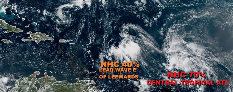
A convectively active wave presently located east of the Leewards has the potential to become a US weather-maker regardless of how developed it does or does not become, and with significant impacts likely to be felt either way, we are now starting a Lounge on this system which will probably be Invest tagged within the next day or two and could go on to get named later this week. Development looks most possible in the southwestern Atlantic or even around the Bahamas, later this week. A lot may have to do with if, and if so, how, it interacts with the wave behind it currently in the Central Tropical Atlantic.
NHC currently giving 40% odds, and this could be a little conservative.
The wave east of the Leewards we have been tracking was Invest tagged overnight, 94L, and the title has been updated accordingly.
2025-09-23 06:00 17.2N 60.7W 25 KTS
94L is NINE with the 5PM Advisory package out on Sep 26 and the title has been updated accordingly.
5:00 PM EDT Fri Sep 26
Location: 20.9°N 74.6°W
Moving: NW at 9 mph
Min pressure: 1008 mb
Max sustained: 35 mph
NINE has become Tropical Storm Imelda on Sunday the 28th, and the title has been updated accordingly
2:00 PM EDT Sun Sep 28
Location: 23.9°N 77.3°W
Moving: N at 7 mph
Min pressure: 998 mb
Max sustained: 40 mph
Ciel
Edited by cieldumort (Sun Sep 28 2025 01:59 PM)
|
cieldumort
Moderator
Reged:
Posts: 2664
Loc: Austin, Tx
|
|
Mixed reviews from the EURO and DeepMind ensembles today on the wave presently east of the Leewards.
It is worth noting that DeepMind ensembles have performed quite well and experts are still very much on a learning curve with how to incorporate them into official forecasts.

Above: EPS Ensembles img credit: Tomer Burg

Above: Google DeepMind Ensembles img credit: Tomer Burg
|
cieldumort
Moderator
Reged:
Posts: 2664
Loc: Austin, Tx
|
|
Something worth keeping an eye out on with 94L is the possibility for the island topography, which can get quite high, to force convergence and additional vorticity on the Caribbean side, which also happens to be under less detrimental shear than north of the islands. While the cresting of the wave remains north of the islands, as also seen yesterday, there has been better vorticity, at times even drilling down to the surface with possibly gale force in very localized pockets, in the Caribbean itself.
If nothing else, this interaction could tug 94L to the south side of guidance for a while. An outlier would be for genesis to occur while south of Hispaniola and/or Cuba, but that does not look entirely out of the question (maybe 10% chance).
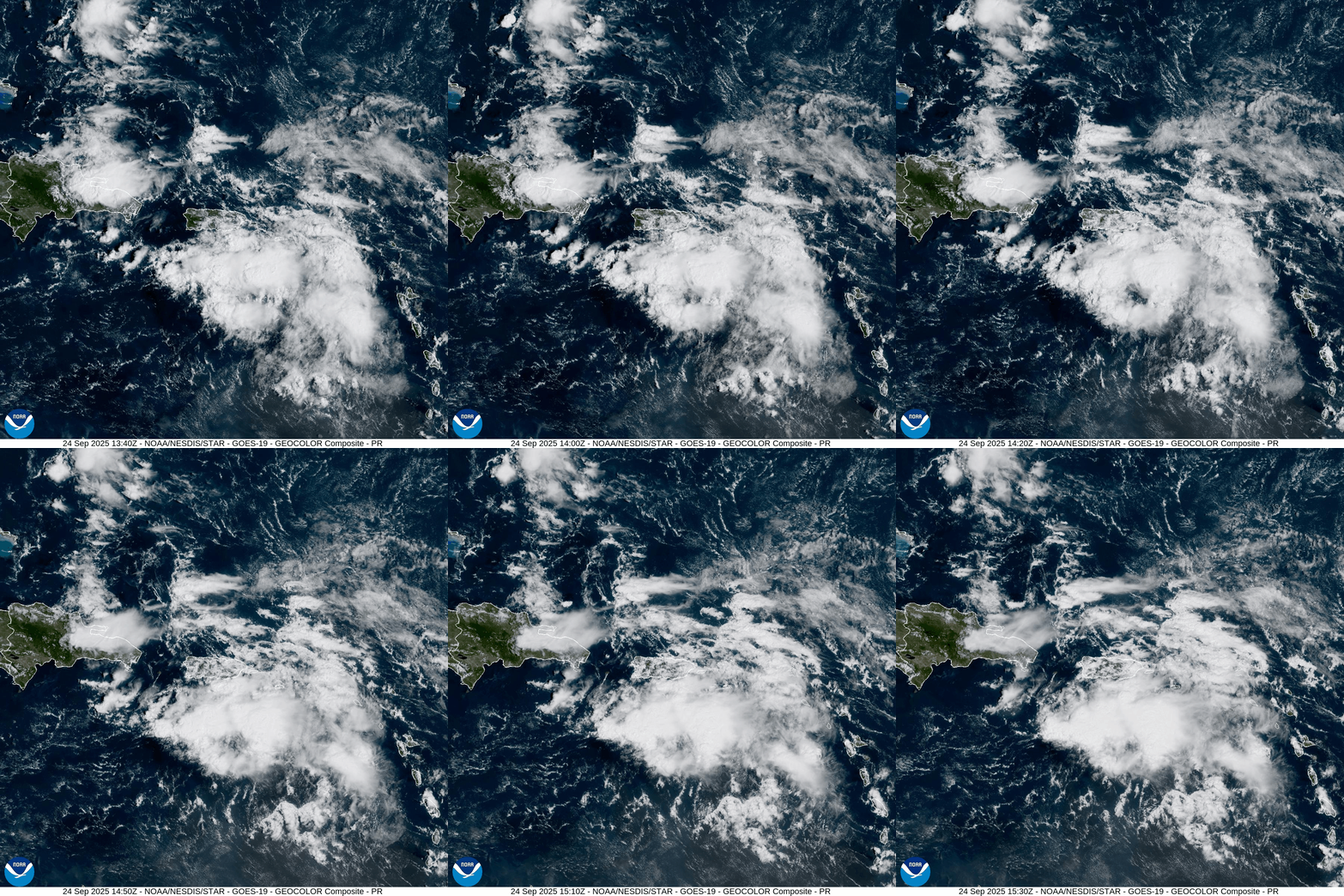
Low level northerlies in the Mona Passage (straight between Hispaniola and PR), as well as in eastern Hispaniola. What could be a touch of westerlies south of there.
|
IsoFlame
Weather Analyst

Reged:
Posts: 412
Loc: One block off the Atlantic Oce...
|
|
Quote:
There has been better vorticity, at times even drilling down to the surface with possibly gale force in very localized pockets, in the Caribbean itself. Low level northerlies in the Mona Passage (straight between Hispaniola and PR), as well as in eastern Hispaniola. What could be a touch of westerlies south of there.
When the cirrus shield thinned out some this afternoon, visible satellite loop had a low-level cyclonic circulation south of Puerto Rico, just north of a large cluster of deep convection. The buoy south of Ponce Puerto Rico NDBC Station #42085 reports dropping pressure, steady S/SE wind of 10-12 kts and SST 86.2F. The station near the west shore of Mona Island PR also reporting dropping pressure this afternoon with SST 87.4F (no wind data).
--------------------
CoCoRaHS Weather Observer (FL-VL-42) & Surf Forecaster: https://www.surf-station.com/north-florida-surf-forecast-3/
|
IsoFlame
Weather Analyst
Reged:
Posts: 412
Loc: One block off the Atlantic Oce...
|
|
Satellite surface wind analysis for 94L
--------------------
CoCoRaHS Weather Observer (FL-VL-42) & Surf Forecaster: https://www.surf-station.com/north-florida-surf-forecast-3/
|
MikeC
Admin
Reged:
Posts: 4817
Loc: Orlando, FL
|
|
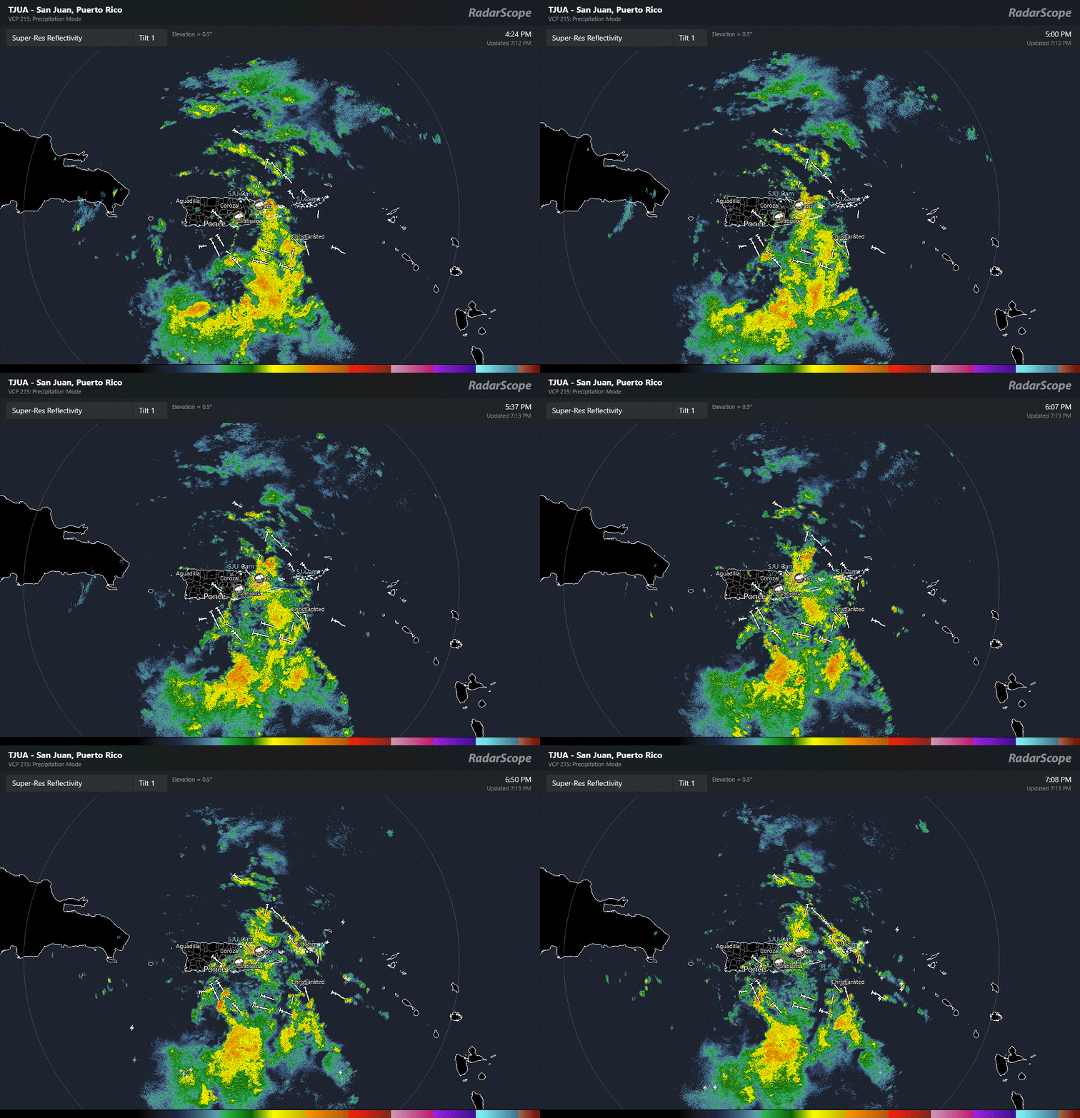
San Juan Radar:
|
MikeC
Admin
Reged:
Posts: 4817
Loc: Orlando, FL
|
|
the 0z earlies, 18Z euro ensembles all show the chance of a NC (or US) landfall a lot higher, although it's still up in the air if/when it develops, and Hispaniola interaction is sitll a thing as well as impacts from Humberto meaning it's all still up in the air.
|
cieldumort
Moderator
Reged:
Posts: 2664
Loc: Austin, Tx
|
|
94L remains a bit trapped under the mountainous terrain of the islands lining the northern Caribbean. Meanwhile, with Humberto (from 93L) developing early and consequently pulling away a bit, there may be both less of a tug from Humberto for 94L to head out to sea combining with the general westerly forcing from interaction with the islands. At least, that is my read early in the morning.
Many models, for whatever their reasons, have lurched west with 94L. Many operational and hurricane specific models from overnight 0z runs are now calling for a US landfall. Interestingly, the ensembles are not nearly as on board. Clearly this is still very early with much for models to work out, but the southeast US including Florida up through the Carolinas does look to be much more in play today than at this time yesterday, and the Bahamas specifically look especially vulnerable.
Here are some outcomes from 0z runs. What is impressive is the unanimity of many
GLOBALS
ECMWF - Cat 1-ish landfall on South Carolina Monday afternoon (Sep 29)
GFS - Out to sea
AIFS - Close call for all of the southeast coast before looping around Humberto and out to sea
GDPS ("Canadian") - Cat 1-ish landfall on South Carolina Monday evening (Sep 29)
Hurricane Model Runs
HWRF - Cat 1/2 landfall on North Carolina overnight Monday/Tues (Sep 29-30)
HMON - Cat 1 landfall on South Carolina Monday afternoon (Sep 29)
HAFS-A - Rakes the Bahamas as a Cat 4 over the weekend. End of run has it Cat 2/3 just offshore of eastern Florida overnight Monday (Sep 28/29)
HAFS-B - Rakes the Bahamas as a Cat 3/4 over the weekend. End of run has it Cat 2/3 offshore of north-central Florida overnight Monday (Sep 28/29)
|
cieldumort
Moderator
Reged:
Posts: 2664
Loc: Austin, Tx
|
|
Four-run trend of the Google DeepMind ensembles. Cr: Ben Noll
|
Kraig
Weather Hobbyist

Reged:
Posts: 91
Loc: Jupiter, Fl
|
|
Quote:
Hurricane Model Runs
HAFS-A - Rakes the Bahamas as a Cat 4 over the weekend. End of run has it Cat 2/3 just offshore of eastern Florida overnight Monday (Sep 28/29)
HAFS-B - Rakes the Bahamas as a Cat 3/4 over the weekend. End of run has it Cat 2/3 offshore of north-central Florida overnight Monday (Sep 28/29)
The 06Z runs of both HAFS A and B are significantly weaker, maxing at strong Cat 1 strengths....
|
cieldumort
Moderator
Reged:
Posts: 2664
Loc: Austin, Tx
|
|
Quote:
Quote:
Hurricane Model Runs
The 06Z runs of both HAFS A and B are significantly weaker, maxing at strong Cat 1 strengths....
Looking at these two 06Z runs, it appears that they both pretty much run the nominal center of 94L through Hispaniola and a significant portion of Cuba, constantly disrupting any real attempt the wave attempts to make to complete TC genesis. This definitely looks like a plausible solution, but the weakness appears to be mostly if not solely the result of this forecast track. A deviation to the south or north of this could result in something much different.
Recon is finding the air north of Hispaniola to be fairly dry throughout the column. This could also be a significant inhibiting factor for development, at least in the near term. Looking out past 48 hours, moisture and shear look to be far less an issue, potentially flipping to outright very supportive by the time 94L "would" be over the Bahamas. Tentatively, I would place the zone for best odds of genesis, if it hasn't already formed, or Rapid Intensification, assuming a TC already has formed, to be around the Bahamas. Even closer to the southeast at time time looks to be supportive.
All speculation for now. Need more recon data into the models. Hopefully by tonight's 0z runs a clearer picture emerges.
|
Robert
Weather Analyst
Reged:
Posts: 371
Loc: Southeast, FL
|
|
Nobody mentioned the runs the 32 k has consistently had it develop south of Cuba, 12Z run this morning has the low centered north of jaimaca nothing in the Bahamas monday.. while all the other models have it in the bahamas.
|
cieldumort
Moderator
Reged:
Posts: 2664
Loc: Austin, Tx
|
|
Quote:
Nobody mentioned the runs the 32 k has consistently had it develop south of Cuba, 12Z run this morning has the low centered north of jaimaca nothing in the Bahamas monday.. while all the other models have it in the bahamas.
NAM might be my least favorite model for TCs. Convection allowing model (CAM) that almost always overdoes tropical systems with convective feedback, which tends to make TCs form where realistically they aren't likely to and/or rapidly deepen when they aren't likely to. I'd say it is possible, but an outlier, still putting the odds of genesis in the Caribbean itself at about 10%.
|
Kraig
Weather Hobbyist
Reged:
Posts: 91
Loc: Jupiter, Fl
|
|
By 12Z Sunday, there is significant dry air intrusion over Florida at the 700-300mb mid levels. By 0Z Monday, this dry air is wrapping around the south and east sides of the storm keeping Florida in a dry slot for the duration of the event! A close call but it will end up being a Carolina's storm!
|
CFHC

Reged:
Posts: 198
Loc: East Central Florida
|
|
Bahamas are going to get a lot of impacts, Florida is going to be on the dry side of the storm, so we won't see much. But the Euro/GFS is not good for the Carolinas, and potential inland flooding (maybe even Western NC again).
|
IsoFlame
Weather Analyst
Reged:
Posts: 412
Loc: One block off the Atlantic Oce...
|
|
Beach erosion from heavy surf will be the main impact along Florida's east coast (combined sea height offshore could be near15 feet offshore from the Cape: Canaveral East buoy forecast
Should see some fast-moving coastal showers, but I don't expect much more than an inch at best. We could really use
the rain here as the past 2 weeks have been very dry at the tail end of a disappointing wet season in Daytona Beach Shores.
--------------------
CoCoRaHS Weather Observer (FL-VL-42) & Surf Forecaster: https://www.surf-station.com/north-florida-surf-forecast-3/
|
cieldumort
Moderator
Reged:
Posts: 2664
Loc: Austin, Tx
|
|
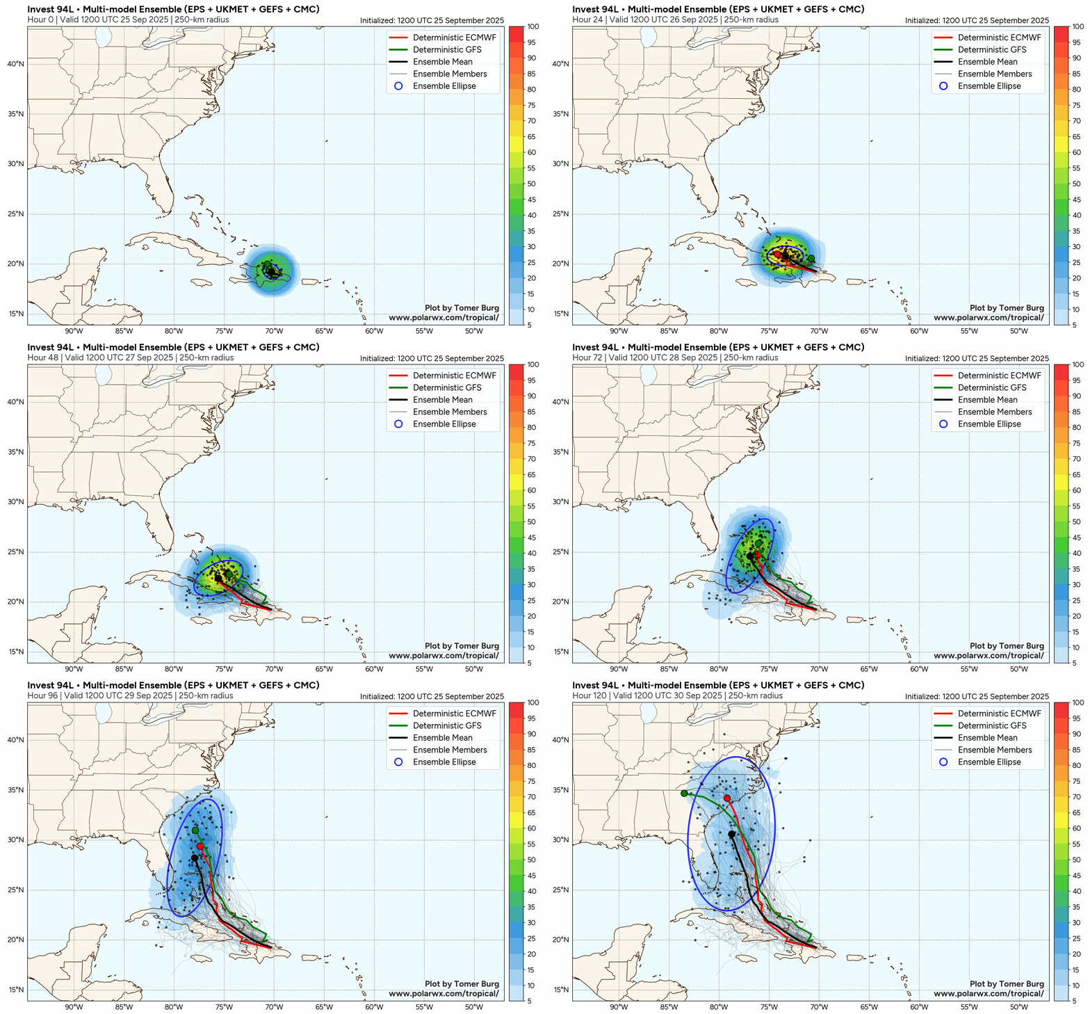
GFS and EURO deterministics, ensembles, ensemble mean, and ellipse, out to 120 hours from 12Z initialization today
Credit: Tomer Burg
|
CFHC
Reged:
Posts: 198
Loc: East Central Florida
|
|
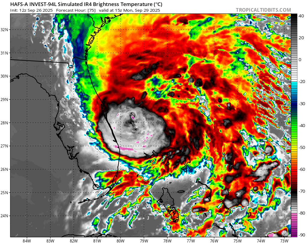
Florda not likely to get landfall, but parts of the east coast may get some gross weather:
|
cieldumort
Moderator
Reged:
Posts: 2664
Loc: Austin, Tx
|
|
|
IsoFlame
Weather Analyst
Reged:
Posts: 412
Loc: One block off the Atlantic Oce...
|
|
I'm watching closely but still sitting on my butt today with no extra prep (beyond what I did back in August the week in advance of Erin) for the potential of 94L to significantly impact coastal Volusia. The uncertainty for potential Imelda to begin to rapidly intensity in the Bahamas then track slowly north over the Gulf Stream 50-75 miles offshore from the Cape is bothersome.
I always feel that the worst-case scenario for Florida's east coast north of the Cape would be a Major tracking slowly NNW parallel and only a few miles offshore from the coast, with the west side of the eye wall wobbling onto land as it rakes the coast. Floyd (110 miles offshore), Mathew (25 miles offshore) and Dorian (95 miles out) come to mind as close (but no cigar) contenders.
The Great Bahamas Hurricane in July 1926 which paralleled the southeast Florida coast as a Major before landfall near New Smyrna Beach as a strong Category 2 also comes to mind.
I'm hopeful given the just issued 5 pm advisory for PTC #9 that Imelda will stay at least 100 miles offshore and not stall or strengthen much (if any) beyond Cat 1.
--------------------
CoCoRaHS Weather Observer (FL-VL-42) & Surf Forecaster: https://www.surf-station.com/north-florida-surf-forecast-3/
|



 Previous
 Index
Index
 Next
Next
 Threaded


 Edit
Edit
 Reply
Reply
 Quote
Quote


