MikeC
Admin
Reged:
Posts: 4819
Loc: Orlando, FL
|
|
Recon is finding the center relatively dry which should keep it from gaining much today. It's mostly a waiting game, Jamaica and points east of wherever the center winds up are going to see the most impacts. Bahamas, Berumda will also want to keep watch once Melissa begins to move, which may not be for a good while (days). I am not concerned for Florida at all for any direct impacts.
|
cieldumort
Moderator

Reged:
Posts: 2666
Loc: Austin, Tx
|
|
Recon, which is still in Melissa, has provided very useful information, much of which is now fed into models and official forecasts.
There are generally two model camps with regard to the cyclone's future:
1. More rapid near-term development/deeper cyclone, favoring a track towards/near/roughly or directly across Hispaniola, and out-to-sea.
2. Slower near-term development/shallower cyclone, favoring a track that misses the first exit, and hooks w or even wsw towards Nicaragua/Honduras, and explosively develops into a history-making-level Major.
This morning's two recon missions suggest that a third camp may emerge in subsequent runs, as the center has reformed northeast of its prior location, into very deep convection. Recon passes have found that pressures have fallen to about 1001mb, with winds, so far, not responding, but likely to do so.
Melissa's forecast is extraordinarily tricky, with several opportunities to escape the Caribbean, but even more opportunities to meander, stall, and even drift southwest. This far greater than usual uncertainty was reflected in the 5AM Advisory Quote:
this should be considered an extremely uncertain forecast, and significant changes could be required
Also, the US East coast is not off the hook, longer-term.
|
cieldumort
Moderator
Reged:
Posts: 2666
Loc: Austin, Tx
|
|
Now that we have invaluable recon data to consider, I am updating my 98L (now Melissa) lifetime maximum intensity best guesses. This is not a forecast for Melissa's intensity at landfall/s.
50 MPH Tropical Storm (Current state): Close to 0%
60-70 MPH mid/high-end Tropical Storm: 1%
Cat 1 Hurricane: 3%
Cat 2 Hurricane: 5%
Cat 3 Hurricane: 14%
130-140 MPH Cat 4 Hurricane: 17%
150-155 MPH High-End Cat 4: 19%
160-170 MPH Cat 5: 20%
175-200 MPH Cat 5: 19%
Over 200 MPH Cat 5: 2%
In summary: Current state: Nearly 0%. Odds of becoming a hurricane of any category: 99%. Odds of becoming a Major Hurricane 91%. Odds of becoming a Cat 5: 41%
This is all based on the Saffir-Simpson Scale, which is to say, just wind. Rainfall, flooding, mudslides and surge from Melissa could become an even greater concern.
|
Owlguin
Weather Hobbyist
Reged:
Posts: 78
|
|
Looks like the center is being exposed again?
|
cieldumort
Moderator
Reged:
Posts: 2666
Loc: Austin, Tx
|
|
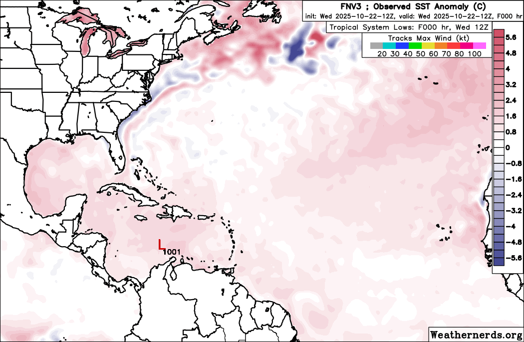
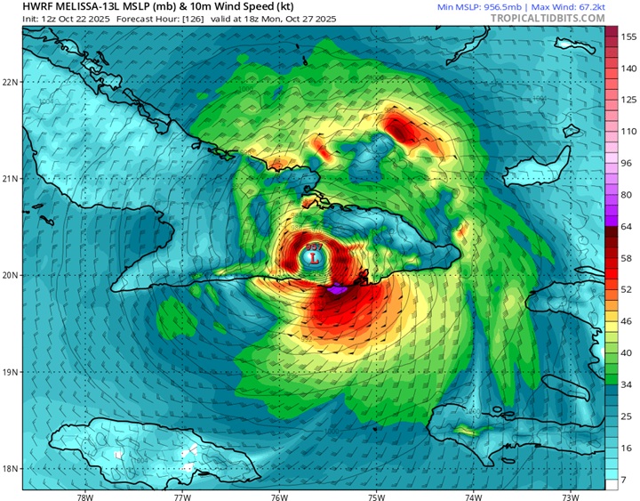
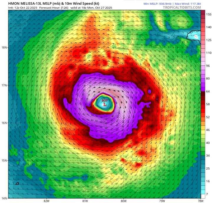
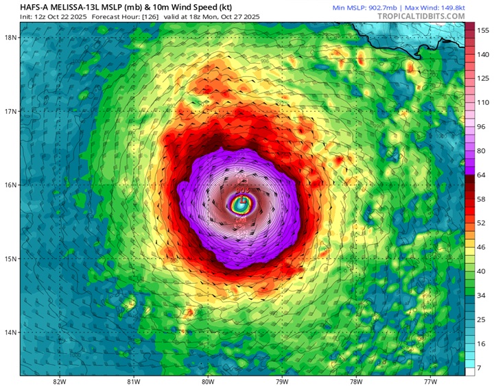
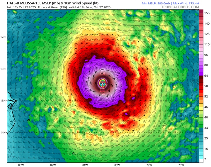
As models have had more and more data to digest and we have had real eyes on the ground, so to speak, here are today's 12Z DeepMind FNV3 ensembles out to 240 hours (10 days), as well as the hurricane models (HWRF, HMON, HAFS-A and HAFS-B) out to the end of their runs (126 hours).
FNV3 Ensemble members out to 240 hours
HWRF for Monday Oct 27 18Z
HMON for Monday Oct 27 18Z
HAFS-A for Monday Oct 27 18Z
HAFS-B for Monday Oct 27 18Z
|
MikeC
Admin
Reged:
Posts: 4819
Loc: Orlando, FL
|
|
Another day of highly sheared system, it's on the edge of getting pushed up like the is showing, but ultimately won't head that way and go along the track. How intense it gets is only limited by the shape it gets in. Tomorrow or so that shear starts to let up, so it'll probably slowly strengthen at first and ramp up when the shear is gone and the outflow gets ventilated by it instead. UKMet keeps it weak, though. Models probably will fluctuate some more, and the tTrack is still variant, but the 's is probably the best weighted.
|
cieldumort
Moderator
Reged:
Posts: 2666
Loc: Austin, Tx
|
|
Melissa is not done disobeying forecast, apparently. Potentially preparing to enter RI overnight, and now a bit west of forecast.
Fine-turning the next few days is academic, to a point. The big picture is of a catastrophic tropical cyclone in the Caribbean, near-term, that also could track across the Bahamas into the eastern seaboard and/or eastern Canada, long-term. Sometimes these granular near-term twists and turns will ultimately have outsized influence on the longer-term track and intensity, however.
|
Robert
Weather Analyst

Reged:
Posts: 371
Loc: Southeast, FL
|
|
Back in 2016 Ukmet was the outlier west, east with hurricane Mathew euro middle. Then they all swinged west once movement began, the trough didFriday. Not dig as strong and the ridging was stronger.
12Z Ukmet still very much further west. Still down in northwest carribean friday.
Edited by Robert (Fri Oct 24 2025 09:04 PM)
|
cieldumort
Moderator
Reged:
Posts: 2666
Loc: Austin, Tx
|
|
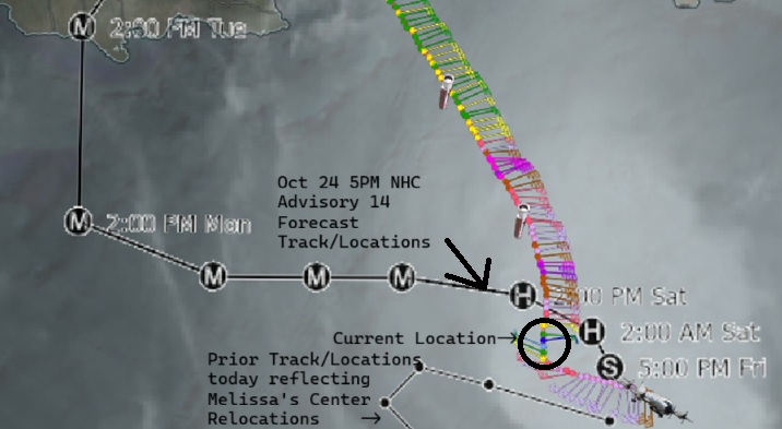
VDM 19 10-25-25-0301z
For intents and purposes, over the past few hours Melissa has been drifting southwest, although the 11PM Advisory holds her track as westbound.
The longer Melissa tracks southwest, potentially the higher upside to her wind and downside to her minimum pressure, as conditions are even more favorable to the southwest of her presently already exceptionally favorable location for RI.
While this is not officially forecast and unlikely to persist for much longer, it is worth keeping an eye on. Such a development has been something I've considered possible for a while.
|
cieldumort
Moderator
Reged:
Posts: 2666
Loc: Austin, Tx
|
|
Some good news, at least for the eastern seaboard, with last night's 0z ensembles from , and Google's DeepMind: Not a single ensemble member out of well over 100 now suggests a bend back towards New England/Canada is even remotely possible.
|
OrlandoDan
Weather Master

Reged:
Posts: 458
Loc: Longwood, FL
|
|
I know Mellisa is far from the Orlando area and is far from expexted to reach here, but are we currently experiecing a Predecessor Rain Event (PRE) here at 16:38 EDT on 10/26/2025?
|
Psyber
Storm Tracker

Reged:
Posts: 242
Loc: Ontario, Canada
|
|
It's unfortunate that this isn't just going to be a fish spinner. Jamaica is getting ready to be smashed. I have friends who live in Montego Bay who report they're being pushed by the police to leave East for Kingston or even farther if possible. Some cellular towers have gone down, but the cellular service is still mostly up.
They're prepared for an expected N N/W change going pretty much right over their house. Even with all the shear, it still maintains a pretty damn good structure. Compact with a tiny eye is sort of lucky, I guess.
--------------------
The safest way to deal with a potential Hurricane hitting you...is to leave and just not be there at all.
|
TanukiMario
Registered User
Reged:
Posts: 7
|
|
This post may not be of the forecasting nature, but if I can help just one person maybe its worth it:
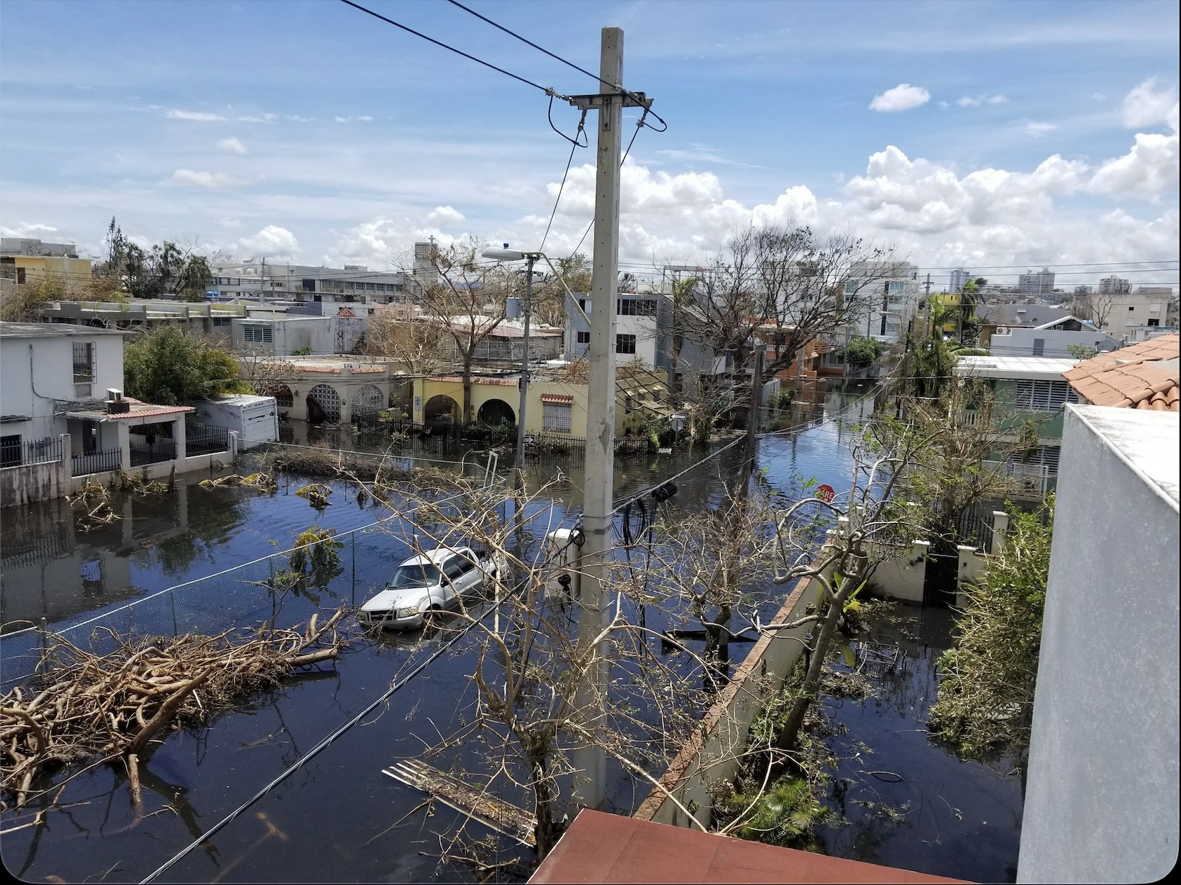
Having been on the ground during Hurricane Maria in Puerto Rico a word of advice to any Jamaicans who may be reading this:
I know you can't leave, its an island, but you can probably find friends and family with a home with a concrete roof and walls. Go there. Find an interior room. Make sure it isn't in a low lying area (places that don't usually flood will flood).
Get canned food and water now - don't think you can wait until after. Don't forget to get your meds. Have a backup plan if you rely on meds that need to be refrigerated.
The worst part is afterwards. No power means ATMs don't work. Groceries can only take cash and many people will hoard. Have some cash on hand and food and water for not just a couple of days, but a couple of weeks (It's an island). So get your food and water now, don't wait until the cupboard is bare. Fill your propane tank and fill your car.
The first day or two everyone is our helping clear debris and being good citizens. By about day five people start to fend for themselves. No comms: Cell towers that haven't fallen have run out of fuel for their generators. It's hot and humid and people are cranky, there isn't cash and you can't run credit cards (no power or comms) so people will start to misbehave. If you have fuel and a generator or other supplies, don't flaunt them. Drive sparingly, save fuel.
It will be slow getting ports back up and running, so supplies will be slow to arrive (it's an island). Prepare for many weeks of no power. Many weeks (not days). Possibly a lack of running water as well. Don't wade into standing water (My house didn't flood, but I got a skin infection walking to my house because sewage eventually mixes with the standing rainwater).
I know this sounds kinda end of times-ish but modern people don't realize how dependent we are on tech (electricity, communications, refrigeration, ATMs and card terminals) and its really hard to get basic needs met unless you have a core group of friends and family, especially for people with special needs.
Good luck.
Edited by TanukiMario (Mon Oct 27 2025 08:40 PM)
|
Psyber
Storm Tracker
Reged:
Posts: 242
Loc: Ontario, Canada
|
|
I would only add that you must be prepared to be the only one who can help you. That's one of the most important forecasts of them all.
If there is one thing that is the absolute same thing said during every single massive landfall, it is that the people always say, "But there's nobody here helping, there's no food, there's no clean water, (insert terrible surprise you never considered) etc, etc". Be ready for you to take care of you.
As for Melissa, there's the slowdown and slow turn to the north we expected. Hopefully, it doesn't sit spinning in place because large parts are already hitting the S/SW of Jamaica.
--------------------
The safest way to deal with a potential Hurricane hitting you...is to leave and just not be there at all.
|
cieldumort
Moderator
Reged:
Posts: 2666
Loc: Austin, Tx
|
|
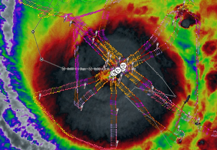
Recon was a little bit slow to get back into Melissa prior to the start of landfall, but was able to get a drop in the south eyewall, which is *not* the Right Front Quadrant, of 252 MPH at 250 meters. h/t Dr. Greg Postel on X
This would usually suggest the RFQ could easily be peaking out even stronger than that.
Making landfall as what could very well be a 190-210 MPH hurricane (certain to get a thorough post-season analysis), with less island to cross in western Jamaica, does not bode well for locations ahead: Cuba, Bahamas, Bermuda.
This could be the most intense hurricane Guantanamo Bay, Cuba has experienced.
|
JMII
Weather Master

Reged:
Posts: 547
Loc: Cape Coral & Margate, FL
|
|
Quote:
Compact with a tiny eye is sort of lucky, I guess.
Similar to Andrew, your dealing with a 30 mile wide EF-4 tornado. Any location that experiences the eyewall will be "erased" 
--------------------
South FL Native... experienced many tropical systems, put up the panels for:
David 79 - Floyd 87 - Andrew 92 - Georges 98 - Frances 04 - Wilma 05 - Matthew 16 - Irma 17
Lost our St James City rental property to Ian 22
|
cieldumort
Moderator
Reged:
Posts: 2666
Loc: Austin, Tx
|
|
|


 Threaded


