TS2
Verified CFHC User
Reged:
Posts: 19
Loc: Orlando, Florida
|
|
I'm changing the Cyclone from Flora to so here is my 6th entry.
Hurricane was the fourth-most intense Atlantic hurricane ever recorded and the most intense tropical cyclone ever observed in the Gulf of Mexico. caused $11.3 billion in damage on the U.S. Gulf Coast in September 2005. was the seventeenth named storm, tenth hurricane, fifth major hurricane, and third Category 5 hurricane of the 2005 Atlantic hurricane season.
Rita made landfall on September 24 near the Texas-Louisiana border as a Category 3 hurricane on the Saffir-Simpson Hurricane Scale. It continued on through parts of southeast Texas. The storm surge caused extensive damage along the Louisiana and extreme southeastern Texas coasts and completely destroyed some coastal communities. The storm killed seven people directly; many others died in evacuations and from indirect effects.
CIMSS Track Montage
Figure 1: The Track of Hurricane with images of the Cyclone at Specific Times.
Image Credit: NOAA/CIMSS
The storm system that became formed at the tail of an old frontal boundary, where convection and low-level circulation around an upper-level low developed steadily for over two days. A surface low formed near the disturbance, and the season's 18th tropical depression soon formed east of the Turks and Caicos. Less than a day after forming, the depression became the 17th tropical storm of the season on September 18 and was named . A mandatory evacuation was ordered for the entire Florida Keys.
Rita was slow to become a hurricane; National Hurricane Center reports early on September 20 estimated the storm's sustained surface winds at hurricane force (65 knots or 75 mph). However, lacked a complete eyewall; forecasters identified as a tropical storm with 60 knots (70 mph) winds overnight. Aircraft observations released at 9:45 a.m. EDT showed a closed eyewall and winds clearly at hurricane strength. Four hours later, the reported that had reached Category 2 hurricane strength, with 86 knots (100 mph) maximum sustained winds.
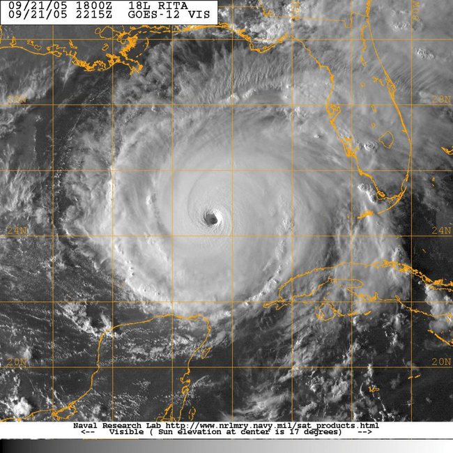
Warm water in the Gulf of Mexico, 1° F (0.5 °C) above average, favored storm intensification. As entered the Gulf, rapid intensification began. National Hurricane Center advisories issued every three hours each showed strengthening from 5 p.m. EDT on September 20 to 11 a.m. EDT on September 21, when 's maximum sustained winds increased to 121 knots (140 mph). continued to gain strength unabated. An update at 2:15 p.m. CDT (1815 UTC) said maximum winds had increased to 120 knots (150 mph) and 's minimum pressure was 920 hPa. Less than two hours later, at 3:55 p.m. CDT, another update reported that had strengthened to a Category 5 hurricane, with maximum wind speeds of 143 knots (165 mph). At 6:50 p.m. CDT, a reconnaissance aircraft recorded pressure of 899 hPa away from the storm's center; the actual central pressure was thought to be lower still. At 10 p.m. CDT, reached its maximum intensity, with sustained winds of 156 knots (180 mph) and an estimated minimum pressure of 895 hPa.

Figure 2: Hurricane at peak strength.
Image Credit:

Figure 3: Hurricane at Landfall on the Gulf Coast
The use of the name "Rita" reflects the record-breaking activity of the 2005 hurricane season: only once before had a name starting with "R" (the seventeenth name in the list each season) been used for an Atlantic storm, in 1995 for Hurricane Roxanne. was, actually, the third seventeenth storm to form in a season since tropical storm naming began in 1950. However, in the 1969 season, under less-sophisticated forecasting systems, many tropical storms were not named; the seventeenth storm of 1969 was named Hurricane Martha.
Other records set by :
Earliest 17th named storm in Atlantic hurricane season
Fourth most-intense storm in Atlantic basin
Greatest one-hour pressure drop in Atlantic basin
Most intense hurricane in the Gulf of Mexico (breaking record set by Hurricane three weeks earlier)
My next post will be about Hurricane Gilbert (1988)
--------------------
Dr. Joe Smith
Substitute Teacher at University of Central Florida
GreatWeatherForums
Edited by danielw (Sun May 27 2007 12:31 AM)
|
dem05
User
Reged:
Posts: 368
Loc: Port Charlotte, FL
|
|
I like that you are doing this. Here's a picture for ya. For work purposes, I was in Marathon in the Middle Keys when and went though. This is a picute I took during from the second floor window of the Monroe County Government Bldg. was much worse, and being at the highest point on the island, we watched the storm surge roll through (I have pics of that too). Folks...Always pay attention to those evacuation orders for storm surge, Florida Keys and/or no matter where you reside!!! Trust me.
|
|


 Threaded


