cieldumort
Moderator

Reged:
Posts: 2484
Loc: Austin, Tx
|
 Atlantic Turns On: Fred, Grace and Potentially Henri
Sun Aug 15 2021 05:18 AM
|
|
|
9:00 AM EDT 16 August 2021 Update
Fred now has winds of 60mph and a pressure of 993mb according to recon reports and a special update from the National Hurricane Center.
6:00 AM EDT 16 August 2021 Update

Fred may be making a run for high-end Tropical Storm and still possibly even hurricane before landfall.
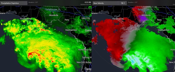
As Fred has been approaching predawn Monday, velocities high up in the cyclone based out of KTLH (Tallahassee) and KEVX (Elgin) have been running consistently above 60 MPH and occasionally perhaps as high as 90 MPH in heavy precip. A not unreasonable reduction ratio of 80% could already net out as high 48-72 MPH at the surface. In addition, an inner core feature with hints of an eye-like feature has been intermittently showing up on radar as well. This is often an indication of a healthier system, and indeed it appears that Fred's low level circulation has come back into some better alignment with the deep convection and mid-level circulation.
With the 4 AM CT Advisory holding Fred at 50 MPH, should current radar trends continue, especially if soon to be verified through recon, upward adjustments could be coming. A stronger Fred may result in both larger life-threatening storm surge and wind damages. The Advisory details note that 65 MPH high-end Tropical Storm heading into landfall is definitely in the realm of expected possibilities.
11:00 PM EDT 15 August 2021 Update
Tropical Storm Fred is continuing to strengthen tonight, now up to a 50MPH storm and pressure has fallen to 999mb. Landfall is expected to be just west of Laguna Beach, FL. early tomorrow evening. Forecast calls for a 60mph system, but there is a chance it could be stronger.
Almost all the weather is on the east side of the center, so areas east can expect the worst, while those west may not see much of anything. Surge is forecast to be the worst east of Panama City Beach, 3-5ft. west of the Steinhatchee river, and more of 2-4ft toward Cedar Key/Yankeetown.
Tropical Depression Eight has formed northeast of Bermuda, and a Tropical Storm Watch is now issued for Bermuda. The system is forecast to do a loop around Bermuda, with a high point of 65MPH. If it were to get named it would be Henri.
Grace is a tropical depression again and remains very unorganized. Heavy Rainfall and Mudslides are possible on Hispaniola, including the areas impacted by the recent earthquake. Grace remains very disorganized, and a chance remains the loose center may slip south of the islands, but either way Grace is expected to remain weak, but cause a great deal of rainfall in the short term.
11:00 AM EDT 15 August 2021 Update
Fred has regained Tropical Storm Status as is now forecast to landfall as a moderate 50mph Tropical Storm in the Panhandle. A Storm Surge Warning has been issued for the coast of the Florida Panhandle from Indian Pass to Steinhatchee River and a Tropical Storm Warning is now in effect for the coast of the Florida Panhandle from Navarre to the Wakulla/Jefferson County line.
Grace remains a disorganized system, with only slight evidence of curved bands of deep convection on satellite imagery. It is forecast to move into Hispaniola and bring heavy rainfall there, including Haiti where it is not needed.
96L Near Bermuda has a 30% chance to develop over the next 5 days, those in Bermuda should watch this system closely.
5:00 AM EDT 15 August 2021 Update
...TROPICAL STORM WATCH ISSUED FOR PORTIONS OF THE NORTHERN GULF COAST...
NHC: A Tropical Storm Watch has been issued for portions of the north-central Gulf coast from the Alabama/Florida border eastward to Ochlockonee River, Florida.

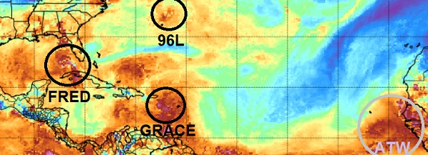
Above: Total Precipitable Water (TPW) Base image credit: CIMSS
Tropical Cyclone development often comes with just a single system phase, but at other times, when stars align, cyclones come in bunches, sort of like bananas. And like banana trees, when this type of basin phase begins to fruit, not all the bananas ripen at the same time, but the trend is for every single one that can ripen, to do so.
The next few days could very well be one of those stretches where things just come into better alignment for more development.
This morning, former "Remnants of Fred," is nearly Tropical Storm Fred, once again. "Disorganized and unclear if actually still a Tropical Cyclone Grace," is still a bit disorderly, but unfortunately, expected to rain heavily on a part of the Caribbean that least needs it right now (Haiti). And elsewhere, newly Invest tagged 96L not far off from Bermuda, could become our next named storm.
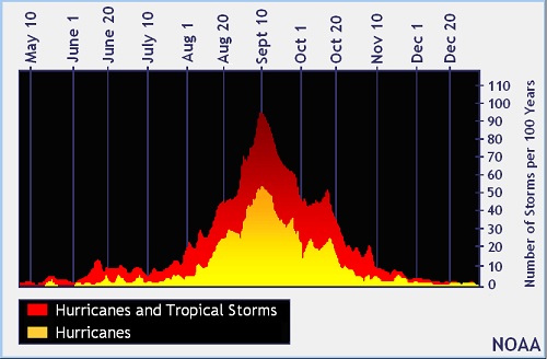
By mid-August, most of the season is usually still ahead

Image credit: NOAA
We sympathize with everyone who says it feels like it should be nearing the end, already. But the fact of the matter is, the season started early, as has been the trend for the past several years now, and if anything, might easily go into overtime this year especially if La Niña develops. Therefore, even if not a single one of these the systems this week were to become significant (just what is "significant?"*) getting all ducks in a row now, so one does not have to rush safety and sustenance preparation in the eleventh hour during a pandemic no less, may be wise regardless. But also, the fact is, we now have three candidates that may actually outperform, as again, the Atlantic basin is showing signs of a favorable phase that could produce 'bunches,' and it probably won't be the last time that happens this year.
*A "significant" Tropical Cyclone simply isn't just one that produces high wind. That myth needs to be put to bed once and for all. Far more people perish from coastal and inland flooding caused by Tropical Cyclones than from wind damage. Storm surge, flash flooding, etc. It's the water. Hide from the wind, run from the water, and at least two systems this week, Fred and Grace, may end up being dangerous flood makers.
Bulletin of the American Meteorological Society
Fatalities in the United States from Atlantic Tropical Cyclones:Quote:
Roughly 90% of the deaths occurred in water-related incidents, most by drowning. Storm surge was responsible for about half of the fatalities (49%). Rainfall-induced freshwater floods and mudslides accounted for about one-quarter of the deaths (27%)
{{StormLinks|Fred|06|6|2021|6|Fred}}
Model Talk in Fred Forecast Lounge
Read/Report on Fred related conditions in your area here
{{StormLinks|Grace|07|7|2021|7|Grace}}
Grace Forecast Lounge
{{StormLinks|Henri|08|8|2021|8|Henri}}
96L Forecast Lounge
{{StormCarib}}
{{PanhandleMedia}}
{{NortheastGulfRadar}}
{{BermudaNews}}
Edited by MikeC (Mon Aug 16 2021 04:55 PM)
|
|


 Flat
Flat

