cieldumort
Moderator

Reged:
Posts: 2530
Loc: Austin, Tx
|
 Hurricane Debby
Fri Aug 02 2024 01:31 PM
|
|
|
2PM EDT 11 August 2024 Update
The area east of the Caribbean Islands is up to a 90% chance to develop and 80% within the next 48 hours, so it's likely that this will form later tonight or tomorrow and approach the Leeward islands of the Caribbean. Those in the Islands should monitor it closely. Beyond this it's most likely to stay east of the Bahamas and US mainland, but could impact Bermuda. Those in the Leeward Islands, Virgin Islands, Puerto Rico, and the Turks and Caicos and Bermuda should watch this system closely.
7AM EDT 07 August 2024 Update
Tropical Storm Debby is much weaker, but still offshore this morning of South Carolina, after injecting quite a bit of dry air into the center. There is still rainfall from the outer bands of the system reaching as far south as St. Augustine north to Eastern North Carolina, but much less concentrated that before. Debby will likely maintain or slightly strengthen where it is at currently until the forecast landfall sometime tomorrow morning. The strongest winds are on the southeast side over the water currently.
Flooding rains will still be an issue in a few areas.
The other area being watched is losing its chances to develop and now only has a 10% chance to develop.
7AM EDT 06 August 2024 Update
Tropical Storm Debby is in southeastern Georgia just west of Savannah and is expected to move offshore this morning after landfalling at Steinhatchee, FL as a category 1 Hurricane at 7AM August 5th, It has been weakening since, and most of the rain is now on the northeastern quadrant. and reaching well into South Carolina bringing flooding rainfall. A few tail bands still extend well to the south.
Debby is forecast to exit land this morning near Savannah and emerge into the Atlantic waters for a day or so, stop and then landfall again along the coast of South Carolina on Thursday, possibly a little stronger than now and drift north inland bringing more rainfall inland.
Another wave has a 30% chance to develop in the Caribbean, but has some hurdles for doing so.
11PM EDT 04 August 2024 Update
Debby has become a hurricane, the second hurricane of the 2024 Atlantic Hurricane Season. Despite a limited runway of water before landfall, the internal structure of the cyclone continues to improve tonight, and it is still very possible for a strong Cat 1-2 at landfall. Regardless, Debby remains a large and very dangerous tropical cyclone with unusually high potential to produce catastrophic inland flooding and long-lasting surge.
11AM EDT 04 August 2024 Update
Rapid Intensification is now the official forecast heading into landfall, and there is even some possibility that Debby Majors. In addition to these strong hurricane-force winds, dangerous surge, tornadoes and extreme flooding are likely.
Preps to protect life and property should be hurried to completion at this time.
7:30AM EDT 04 August 2024 Update
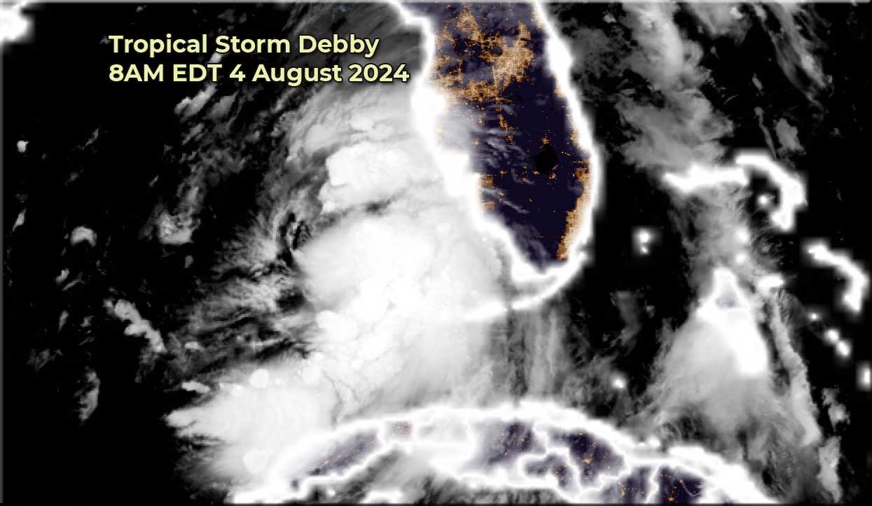
Up to 60mph winds at 8am.
Tropical Storm Debby is slowly strengthening, from a rather broad/sloppy area and is now a 50mph Tropical Storm west of Florida. Bands of rain are moving in along southwest Florida, and with the system trying to consolidate the rain will be delayed in other parts of Florida until later today.
Landfall is expected to be tomorrow afternoon along the Big Bend as a 85mph hurricane with surge up to 10 feet in some areas there, then move slowly across Florida and Georgia toward the Atlantic and be near Savannah and around the South Carolina Lowcountry by Wednesday into Thursday causing a lot of flooding rain and surge along there.

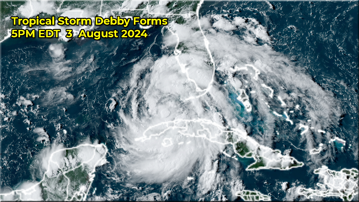
5:00PM EDT 03 August 2024 Update
Tropical Storm Debby has formed with 40mph winds north of Cuba. A hurricane is now forecast before landfall in the Big Bend.
A Hurricane Warning is now in effect for the Florida Gulf coast from the Suwannee River to the Ochlockonee River.
A Tropical Storm Warning is now in effect for the Florida coast west of the Ochlockonee River to Indian Pass, and for the Florida coast east of the Suwannee River to Yankeetown.

7:45AM EDT 03 August 2024 Update
Hurricane Watches are now up from from Aucilla River just east of St. Marks, FL to Yankeetown, Florida South of Cedar Key as there exists potential for the system to reach hurricane strength before landfall. Tropical Depression Four is nearing the western Cuba coastline an expected cross over Cuba and Havana by early Afternoon and enter the Gulf of Mexico. Tropical Storm Warnings are up for the rest of the west coast of Florida. The next name is Debby.
Once landfall happens it's expected to slowly move over Florida and Georgia and reemerge into the Atlantic where it could slow down greatly. Those in Southeast Georgia, and the South Carolina Lowcountry as well as eastern North Carolina should be watching this very closely as this system may be near/over you for several days according to the forecast, and if it stalls over water the potential is there for it to restrengthen.
11PM EDT 02 August 2024 Update
Tropical Depression Four has formed south of Cuba, with Tropical Storm watches and warnings up for parts of the Keys and West coast of Florida currently. The hurricane center calls out in the official discussion that it's possible for a hurricane to form before landfall, if the system maintains itself slightly more than expected. However the current forecast calls for just shy of hurricane with 70mph winds before landfall somewhere in the cone region. Those in the cone need to monitor this closely.
8PM EDT 02 August 2024 Update
It is becoming apparent that development may be starting off the southern coast of Cuba.
Throughout the day, the system overall has been tugged between competing lobes along its wave axis that crosses the island nation from south to north, with its mean center being tracked by NHC. Increasingly, it appears that the aid of a richer, more unobstructed moist inflow from the south and west is benefiting the southern lobe, and unless this gives up the ghost, merges, or loops around cyclonically to the north, genesis may happen there. This would likely shift the forecast track to the left and increase the odds of a system with more time over very warm water, and may even increase the risk of a crawl or stall prior to or just around the time of landfall.
It is important to keep in mind that forecasting the track and intensity of a potential tropical cyclone is often less reliable than forecasting a bona fide cyclone, and those with interests to the left of the recent NHC cones may want to begin paying much more attention.
Original Update
Advisories have begun for Potential Tropical Cyclone Four. Keep in mind, this is the first of many, and could be taken with a grain of salt. While modeling has come together much more with a forecast that cuts across the Florida peninsula and lands back over water along the southeast coast, these model runs are made on a system that 1. Has not yet formed (The P in PTC FOUR does stand for Potential) and 2. Has yet to have had the benefit of recon missions and 3. Is being made for a system still largely over land (Cuba now).
At present, NHC does have a forecast out that is nonetheless of relative confidence. NHC KEY MESSAGES are as follows: Quote:
Key Messages:
1. Heavy rainfall may result in flash and urban flooding across portions of Florida and the Southeast this weekend through Wednesday morning. Isolated river flooding will also be possible.
2. Tropical storm conditions are expected Saturday night within the warning area in southwest Florida from East Cape Sable to Bonita Beach where a Tropical Storm Warning has been issued. Tropical storm conditions are possible in the Florida Keys on Saturday and along the Florida west coast north of Bonita Beach to Aripeka Saturday night and Sunday where a Tropical Storm Watch is in effect.
3. Coastal flooding is possible along portions of the west coast of Florida over the weekend.
4. Interests elsewhere in Florida and along the southeast coast of the United States from Georgia to North Carolina should monitor the progress of this system.
For some deeper model talk as well as speculation as to where exactly FOUR will form and will be going, join us in the Debby Forecast Lounge
And for more official links
{{StormLinks|Debby|04|4|2024|Debby|Debby}}
{{StormLinks|PTC5|05|5|2024|PTC5|Potential Tropical Cyclone Five}}
{{StormCari1b}}
{{NortheastGulfRadar}}
{{SCMedia}}
{{SERadar}}
Edited by MikeC (Sun Aug 11 2024 04:17 PM)
|
|



 Flat
Flat

