Current Radar or Satellite Image

Flhurricane.com - Central Florida Hurricane Center - Tracking Storms since 1995Hurricanes Without the Hype! Since 1995


Clean up and rescue operations in the wake of major hurricanes Milton and Helene continue. No new threatening storms on the immediate horizon.
Days since last H. Landfall - US: Any 6 (Milton) , Major: 6 (Milton) Florida - Any: 6 (Milton) Major: 6 (Milton)


General Discussion >> 2024 Forecast Lounge

cieldumort
Moderator


Reged:
Posts: 2473
Loc: Austin, Tx
Re: 91L Lounge
      Sun Sep 08 2024 02:30 AM

Invest 91L remains messy and things look as though they could go any number of ways, from never organizing enough all the way to strong hurricane. This shouldn't be a surprise given how oddly this entire season has been playing out.

As of 1AM CDT, NHC's latest TWO assigns a 70% chance of 91L becoming a TC within 48 hours and 80% within 7 days. This seems very reasonable, but still does little to nothing to illuminate just how significant a TC. We should know a lot more once recon has spent some time in there tomorrow afternoon.

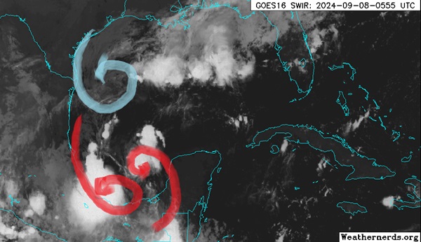
At present, the system we are tracking as 91L consists of two lobes tied to each other, while also starting to interact with an approaching former-90L, that swirl having largely separated from its parent front. So, there could soon even be three lobes interacting with each other.

Recent microwave passes argue for the eastern lobe of 91L to dominate, despite that the westernmost lobe, which is sporting a ball of very deep convection, could already be producing winds somewhere between 30 and 35 knots and is somewhat closed off at the surface.


Light blue: Old Invest 90L non-tropical low
Red: The west and east lobes of Invest 91L
Base image credit: Weathernerds.org

As old 90L continues south and the eastern lobe of 91L already wants to track north as it is rounding Atlantic high pressure, the path of least resistance should be to eject to the north to northwest, possibly hooking around old 90L and getting pulled more to the left for a while. All of this speculation, but models generally want to bring the system inland anywhere from south of Brownsville, TX (generally weaker) to eastern Louisiana (generally stronger).

Post Extras Print Post   Remind Me!     Notify Moderator


Entire topic
Subject Posted by Posted on
* Francine Lounge cieldumort Sun Sep 08 2024 02:30 AM
. * * Re: Francine Lounge cieldumort   Mon Sep 09 2024 05:15 PM
. * * Re: Francine Lounge cieldumort   Mon Sep 09 2024 11:36 AM
. * * Re: Francine Lounge cieldumort   Mon Sep 09 2024 10:25 AM
. * * Re: SIX Lounge cieldumort   Mon Sep 09 2024 09:34 AM
. * * Re: SIX Lounge MikeCAdministrator   Mon Sep 09 2024 07:55 AM
. * * Re: SIX Lounge Robert   Mon Sep 09 2024 08:34 AM
. * * Re: SIX Lounge cieldumort   Mon Sep 09 2024 11:11 AM
. * * Re: 91L Lounge cieldumort   Sun Sep 08 2024 02:51 PM
. * * Re: 91L Lounge cieldumort   Sun Sep 08 2024 02:30 AM
. * * Re: BOC Wave/Front cieldumort   Sat Sep 07 2024 01:52 AM

Extra information
0 registered and 254 anonymous users are browsing this forum.

Moderator:  


Forum Permissions
      You cannot start new topics
      You cannot reply to topics
      HTML is disabled
      UBBCode is enabled

Rating:
Thread views: 2412

Rate this thread

Jump to

Note: This is NOT an official page. It is run by weather hobbyists and should not be used as a replacement for official sources. 
CFHC's main servers are currently located at Hostdime.com in Orlando, FL.
Image Server Network thanks to Mike Potts and Amazon Web Services. If you have static file hosting space that allows dns aliasing contact us to help out! Some Maps Provided by:
Great thanks to all who donated and everyone who uses the site as well. Site designed for 800x600+ resolution
When in doubt, take the word of the National Hurricane Center