cieldumort
Moderator

Reged:
Posts: 2497
Loc: Austin, Tx
|
 Rafael
Sat Nov 02 2024 12:13 PM
|
|
|
6:00PM EST 9 November 2024 Update
Rafael is winding down after having become the farthest west tracking Major Hurricane in the Atlantic basin in any November on record. Rafael's moisture is funneling into Louisiana this weekend, enhancing flooding rains across this region.
NHC:Quote:
....Rainfall indirectly associated with the moisture from Rafael is expected to lead to 3 to 6 inches of rain, with local amounts to 10 inches, across portions of Southwest and Central Louisiana through Sunday morning. This rain will lead to potentially significant flash flooding....
4:00PM EST 4 November 2024 Update

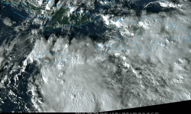
EIGHTEEN has strengthened into Tropical Storm Rafael. Rafael is forecast to become a hurricane in short order, and has the potential to undergo RI as it heads towards Cuba.
NWS National Hurricane Center Miami FL AL182024
400 PM EST Mon Nov 04 2024
...DEPRESSION STRENGTHENS INTO TROPICAL STORM RAFAEL...
...TROPICAL STORM CONDITIONS EXPECTED TO BEGIN IN JAMAICA LATE TONIGHT...
SUMMARY OF 400 PM EST...2100 UTC...INFORMATION
----------------------------------------------
LOCATION...15.5N 76.7W
ABOUT 175 MI...280 KM S OF KINGSTON JAMAICA
ABOUT 395 MI...635 KM SE OF GRAND CAYMAN
MAXIMUM SUSTAINED WINDS...45 MPH...75 KM/H
PRESENT MOVEMENT...N OR 10 DEGREES AT 9 MPH...15 KM/H
MINIMUM CENTRAL PRESSURE...997 MB...29.44 INCHES
WATCHES AND WARNINGS
--------------------
CHANGES WITH THIS ADVISORY:
A Tropical Storm Watch has been issued for the Lower and Middle Florida Keys from Key West to west of the Channel 5 Bridge, and for the Dry Tortugas.
SUMMARY OF WATCHES AND WARNINGS IN EFFECT:
A Hurricane Warning is in effect for...
* Cayman Islands
A Hurricane Watch is in effect for...
* Cuban provinces of Pinar del Rio, Artemisa, La Habana, Mayabeque, Matanzas, and the Isle of Youth
A Tropical Storm Warning is in effect for...
* Jamaica
A Tropical Storm Watch is in effect for...
* Cuban provinces of Villa Clara, Cienfuegos, Sancti Spiritus, Ciego de Avila, Camaguey, and Las Tunas
* Lower and Middle Florida Keys from Key West to west of the Channel 5 Bridge
* Dry Tortugas
10:00AM EST 4 November 2024 Update
Recon finds PTC 18 has become a Tropical Cyclone, therefore is now TD 18 and soon to become Rafael based on everything we see.
SUMMARY OF WATCHES AND WARNINGS IN EFFECT:
A Hurricane Warning is in effect for...
* Cayman Islands
A Hurricane Watch is in effect for...
* Cuban provinces of Pinar del Rio, Artemisa, La Habana, Mayabeque, Matanzas, and the Isle of Youth
A Tropical Storm Warning is in effect for...
* Jamaica
A Tropical Storm Watch is in effect for...
* Cuban provinces of Villa Clara, Cienfuegos, Sancti Spiritus, Ciego de Avila, Camaguey, and Las Tunas
1:00PM EST 3 November 2024 Update

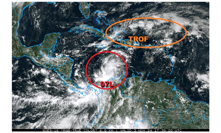
Above: Two Areas of Interest in the W ATL that have potential to become TCs within the next 48 hours.
Of greatest interest is Invest 97L, which early modeling suggests could become yet another hurricane in short order. Recon is investigating this incipient cyclone today, and the data collected will used by these models to greatly improve their forecast simulations going forward.
Original Update
Conditions favorable for a back-loaded 2024 Atlantic Hurricane Season continue, and we are now watching four areas of interest in the Atlantic, one of which has been named today (Patty), and another that has just been Invest tagged this morning (97L).
Patty has become the sixteenth named storm of the season. A Tropical Storm Warning is up for all of the Azores islands in the northern Atlantic.
Closer to home, Invest 97L is likely to become a named storm over the next few days and interests in and around the Caribbean may want to begin paying closer attention. While models suggest a track towards the southern US is very possible, there are a number of known unknowns, and it is too soon tell. We are already doing some deeper dives into its potential in the Rafael Forecast Lounge
{{StormLinks|Patty|17|17|2024|Patty|Patty}}
{{StormLinks|Rafael|18|18|2024|Rafael|Rafael}}
Edited by cieldumort (Sat Nov 09 2024 06:20 PM)
|
|


 Flat
Flat


