MikeC
Admin
Reged:
Posts: 4835
Loc: Orlando, FL
|
 Erin begins to leave the stage as others start to step in
Sat Aug 09 2025 11:25 AM
|
|
|
11:45AM EDT 21 August 2025 Update
Erin continues pulling away from land but impacts remain as the cyclone is very large. Erin should continue to track ENE and is forecast to undergo post-tropical transition in the next 2-3 days or so.
Erin Key Messages from today's 11AM NHC UpdateQuote:
KEY MESSAGES:
1. Erin will continue to produce life-threatening surf and rip currents along the beaches of the Bahamas, much of the east coast of the U.S., Bermuda, and Atlantic Canada during the next several days. Beachgoers in those areas should follow advice from lifeguards, local authorities, and beach warning flags.
2. Storm surge flooding and tropical storm conditions will continue on the North Carolina Outer Banks today. The storm surge will be accompanied by large waves, leading to significant beach erosion and overwash, making some roads impassible.
3. Tropical storm conditions are expected today along the Virginia coast. Wind gusts to tropical storm force are likely along portions of the remainder of the U.S. Mid-Atlantic and southern New England coasts today through early Friday.
4. Tropical storm conditions are possible on Bermuda this afternoon through early Friday. Gusts to gale force are possible along the coast of Nova Scotia on Friday and the Avalon Peninsula of Newfoundland on Saturday.
There are now also three other systems in the Atlantic being monitored by NHC.
First, and closest to land, newly Invest-tagged 90L is approaching the northern Leewards. This feature may very well become our second hurricane of the year, and while likely to head out to sea, interests from the northern Caribbean islands to Bermuda may want to watch.
Second, the robust wave behind 90L we have been tracking continues on a WSW trajectory and its window for TC genesis now appears to be a little longer than NHC was thinking early on. As this system is still undeveloped and traveling at low latitude, despite a forecast of less than ideal conditions for further development ahead, those in and along the eastern Caribbean may want to begin paying it more attention.
Third, the area of low pressure we have been tracking since it was in the northeastern Gulf and went on to track offshore of the Carolinas (Lounge: " Stealthy Low in NE Gulf now Offshore of Carolinas"), continued ENE and became a well-defined, small sub-tropical low yesterday, with more development overnight. This feature now sports a Dvorak of T2 and could become a named storm as it goes harmlessly fishing
Ciel
11:00AM EDT 20 August 2025 Update
With the 11AM NHC Update, Erin is just shy of being a Major Hurricane again.
Erin is an especially large and powerful hurricane now markedly improving in structure, with pressures lowering and maximum winds (sustained and gusts) responding in kind. With regard to Erin's structure, one of the best ways to think about it might be as a very large tropical storm with a now redeveloping Major hurricane in the middle, as mentioned by Dr. Greg Postel, or perhaps as a very powerful subtropical hurricane, reminiscent of Ike (2008) in the Gulf but if one also stuck a Major Hurricane its belly. Either analogy works, with the point being that Erin is not ones garden variety hurricane, and as such, while still tracking offshore and out-to-sea, dangerous and potentially life-threatening impacts will be felt far and wide.
Elsewhere, the large and broad trof/wave we have been watching since its exit out of Africa is now approaching the Caribbean. The northern portion is in the most favorable environment for development and models have started warming up to this again, with development more probable than not perhaps as it nears or round the Leewards in a few days/over the weekend, and NHC has tentatively prepared for an initial flight around 19.0N 61.5W to investigate. Some model runs have also taken its robust southern lobe across northernmost South America and pick it back up in the southwestern Caribbean this weekend and/or next week, and is worth monitoring.
Invest 99L in the far eastern Atlantic is NHC 40% odds of development within the next day or two before conditions for further development are expected to turn unfavorable. This system is likely to track at a lower latitude for a while either way, and is also worth monitoring.
Today is August 20, considered the informal "kick-off" to the real heart of the Atlantic Hurricane Season, and the basin is certainly acting like it.
Ciel
5:00AM EDT 20 August 2025 Update
Hurricane Erin is forecast to slowly restrengthen today. Tropical Storm Warnings are up along the outer banks all the way to the Virginia border now this morning. Overwash has occurred in parts of the outerbanks already. Some webcamera timelapses available https://flhurricane.com/cyclone/animationlist.php?year=all&tag=Erin+%282025%29
5:00PM EDT 18 August 2025 Update
A Tropical Storm Watch has been issued from Beaufort Inlet to Duck, North Carolina including Pamlico Sound
A Storm Surge Watch has been issued from Cape Lookout to Duck, North Carolina.
6:00PM EDT 17 August 2025 Update
Dare County Emergency Management has issued an evacuation of Hatteras Island in the North Carolina Outer Banks (Zone A). Evacuation begins Tuesday Morning. Erin is a very large hurricane that could negatively impact the delicate area even without a direct landfall.
8:00AM EDT 17 August 2025 Update
Hurricane Erin is down to 125MPH winds, with a large eyewall replacement and expanding in size. After the eyewall replacement is complete it has the chance to regain some strength. It is still a major hurricane. It will get close enough to the Turks and Caicos to cause Tropical Storm force winds, thus a tropical storm warning is up, but it will not get close enough for hurricane force winds. Then the official track takes and up and out between North Carolina and Bermuda. It's possible one or the other also receives some fringe heavy bands and possible tropical storm conditions as it does Thursday, but any direct landfall is unlikely.
5:00PM EDT 16 August 2025 Update
5PM Update from NHC holds Erin at 160 MPH, but this is an estimate. Recon has not been in for many hours and while it may be starting to show initial signs of filling, pinhole eye type scenes are very hard to get an intensity handle on, even with recon flying into them, as it becomes a little more challenging to penetrate and drop sondes in what is not totally unlike a couple mile wide tornado vortex in such situations.
Recon is flying in again soon and we should have a better handle on Erin's real current intensity. Could be up, could be down, could very well still be 160.
Ciel
10:00AM EDT 16 August 2025 Update

Above: Erin's past track and points (kept bending south), most recent recon VDMs (keep bending south), and forecast track line and points (keep getting nudged south but still pointing WNW, for now).
Erin may now be a Category 5 hurricane, having undergone completely unforecast Rapid Intensification (RI) overnight, unforeseen by almost all models. However, one Global kept hinting that RI sooner than later ~ along with a more westward track overall ~ was a possibility (ICON).
It is safe to say that there are now some wrinkles in Erin's forecast. Once every so often a hurricane goes wildly off-script. Erin is already there having become this strong, this fast, and tracking south of forecast for eight hours or so now. Forecasts for Erin's strength and importantly track should be taken with a little less certainty this morning, and interests from the Northern Leeward Islands to the east coast of the United States, perhaps particularly the OBX, may want to begin paying much closer attention.
This is a potentially very dangerous hurricane.
Ciel
8:00PM EDT 15 August 2025 Update
Another area, 10% is mentioned on the outlook offshore of the Carolinas. This is the area that flooded parts of Southwest Florida last weekend and moved through the Gulf, over land and back out to sea. This is ahead of Erin, it has about until Monday to potentially develop. Unlikely, but a few ensembles show it.
Forecast lounge for this feature https://flhurricane.com/cyclone/showflat.php?Number=115724&gonew=1#UNREAD
9:00AM EDT 15 August 2025 Update
Recon has found that Erin has become a hurricane. This should be reflected shortly in the next NHC update.
Ciel
8:30AM EDT 15 August 2025 Update
Quick update to highlight the feature a lot closer to land, Invest 98L. Models have woken up and the latest runs are more suggestive of 65% or so odds of it becoming a TD or low-end (wind-wise) TS prior to or just upon pushing ashore somewhere either side of the MX/TX coastal border region later today. More than anything, this is a potential flood threat in areas already hammered by several rounds of flooding last month.
The second recon mission into 98L is en route to provide forecasters and models with critical data not otherwise available.
Ciel
8:45PM EDT 14 August 2025 Update
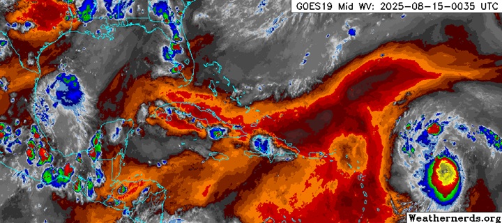
Above: Water Vapor imagery of Erin and Invest 98L at 0035z August 15, 2025 Cr. Weathernerds.org
Erin is on the cusp of being a hurricane tonight. There are a few hints that there could be a center slide or reformation that models have not yet factored in, and this is something to watch overnight into tomorrow morning as there could thus be an adjustment in forecast track on the way. Regardless, at a minimum, very dangerous and potentially life-threatening rip currents will almost be a certainty along a vast portion of the east coast of the United States, and potentially even more significant impacts down the road from there on the east coast and/or Bermuda.
Invest 98L is now up to NHC 50% odds of becoming a Tropical Cyclone. This is in the face of modeling that largely remains unrealistically cool on its potential. Potential Tropical Cyclone Watches and/or Warnings could be put up as soon as later tonight or Friday morning for portions of the Gulf coast from northeastern Mexico to along coastal south Texas. Realistically, this incipient cyclone will likely be coming in as a pretty serious inland flood threat, and interests from deep south Texas into the Texas Hill Country, including locations recently affected by devastating floods may want to start paying close attention to this developing situation and stay tuned to reliable local sources of accurate information.
Ciel
9AM EDT 14 August 2025 Update
Tropical Storm Erin is a 50mph Tropical Storm this morning, still heading generally west, and not expected to reach hurricane strength until the weekend. There's also an area in the Bay of Campeche that has a 20% chance to develop. Erin's forecast to stay north of the Northeastern Caribbean Islands, but they could feel a few fringe outer effects Beyond that it's still a bit tricky, but it's generally headed toward the gap between North Carolina and Bermuda right now. However it's still not comfortably certain yet, recon aircraft are going to be able to head out starting late tonight to help get a better situation and data for the hurricane center.
Modeling is still a bit too uncertain without the recon. Although it is looking better for Bermuda, most models have shifted west of it. However, things like the 6z GFS Ensembles this morning, make it clear how much recon is very much needed.
7PM EDT 13 August 2025 Update
We have just opened up a Forecast Lounge on newly Invest-tagged 98L in the Bay of Campeche. While models suggest its chances are extremely low, this system is landlocked and in a very favorable environment for development. Regardless of development, this system could have the potential to become a serious rain/flood-marker, which is always a very real risk with the "weak" ones. 98L Forecast Lounge
Ciel
5PM EDT 13 August 2025 Update
Tropical Storm Erin has strengthened today to a 50mph Tropical storm.
Erin is unlikely to directly impact the Caribbean islands, however Bermuda and parts of the US east coast could still be affected indirectly (surf, rip currents). It's important to monitor it. Especially in Bermuda and Eastern North Carolina.
Recon aircraft is en route to the area and will go to Erin tomorrow evening. The air force recon planes will be based out of St. Croix, and the NOAA ones out of Barbados.
8AM EDT 12 August 2025 Update
Erin continues to move west quickly around 22mph. Some easterly shear influence should keep it from strengthening much, if at all, for the day or so. Beyond that conditions start to improve, and by the time it gets over to the west conditions greatly improve, especially west of 60 west, where it has a chance to become very intense. The official forecast takes it north of the Caribbean, but folks in the islands will want to watch in the unlikely case anything changes. Low confidence beyond that, Bermuda has the largest chance to see impacts from the system, but other areas including the Bahamas and US coast, although fairly unlikely, cannot be ruled out.
I do want to reiterate how fast and weak the system are now could nudge the forecast track south enough to get closer to (not necessarily) over the Caribbean islands. So do not let your guard down there. The shear may be enough to weaken Erin a bit before it has a chance to strengthen again.
10:15AM EDT 11 August 2025 Update
Tropical Storm Erin has formed in the East Atlantic, it's something to watch closely, but not too concerning at the moment.
Most likely the energy remains offshore of the US, Bermuda will likely need to watch this very closely as it's most likely they will at least see some periphery impacts.
There's still about a 5% chance it could come closer to the Continental United States. The Caribbean Islands are unlikely, the Bahamas (particularly south and east) may need to watch. The Canadian Maritimes will also want to keep tabs on Erin.
It could get close however, close to the outer banks or new England are most likely if it does, but landfall is unlikely. So it's important to watch for trends over the next week or two.
8:15PM EDT 10 August 2025 Update
There have been worse looking tropical lows called TDs than Invest 97L at this time, and it is likely that the system gets the official designation within the next 12 hours or so. Presently, very tropical depression-like conditions are tracking over the Cabo Verde Islands in the far eastern Atlantic.
Over the next 24-48 hours, our incipient Tropical Cyclone (97L) bumps into a region of less unstable and outright subsident air while it tracks over slightly cooler waters. This may stall any further intensification until it reaches the warmer SSTs further west where it has a better chance to become a formidable Cape Verde type hurricane if all the stars remain aligned.
Closer to home, a curious area of low pressure, primarily aloft but also with a surface reflection, exists within a larger trof region in the eastern Gulf. While not yet Invest tagged, there are some ensembles that want to develop it into a depression before it pushes inland over north Florida early in the coming week, and we'll be watching. Lots and lots of rain, either way.
Ciel
Original Update
Invest 97L is a system in the far east Atlantic that just exited Africa, it's poised to a be a long track system. If it gets a name it'll be Erin. The 1995 version of Erin was the first hurricane to be covered by this website.
97L's long term future is uncertain, climatology and ensembles suggest it remains offshore, but odds are only slightly favorable for that outcome, not enough for comfort by any means. So it must be watched by those and the Caribbean and beyond for the trends. If the system becomes a depression it'll get advisories as well. Now that the system is an invest the more specific Hurricane models we begin to be ran on it.
Lots of time to watch where this goes.
More models and speculation can be found in the forecast lounge.
{{StormLinks|Erin|05|5|2025|5|Erin}}
{{StormLinks|99|99|6|2025|99|Invest 99L}}
{{StormLinks|90|90|7|2025|90|Invest 90L}}
{{NCCoastMedia}}
{{StormCarib}}
{{BermudaNews}}
Edited by cieldumort (Thu Aug 21 2025 08:45 PM)
|
|


 Flat
Flat


