F
Current Radar or Satellite Image

Flhurricane.com - Central Florida Hurricane Center - Tracking Storms since 1995Hurricanes Without the Hype! Since 1995


First day of the Atlantic Hurricane season, no tropical activity on the horizon in the near term. Mid August is usually when things pick up.
Days since last H. Landfall - US: Any 285 (Idalia) , Major: 285 (Idalia) Florida - Any: 285 (Idalia) Major: 285 (Idalia)


News Talkback >> 2002 News Articles and Talkback

CFHCAdministrator


Reged:
Posts: 149
Loc: East Central Florida
August and Two Things Worth Watching
      Sun Aug 04 2002 12:08 PM

Minor Update at 4PM:
Looks Like we have TD#2 in the gulf... more to come shortly.
Minor Update at Noon:
The Gulf System is looking bette now, but still too close to land to really leap forth. Aircraft Reconnaissance is heading out tomorrow to check on it.

Original Update:

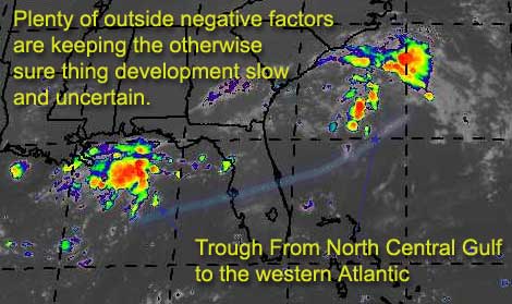
There is a trough of low pressure that's creating two interesting areas worth watching. One in the north central Gulf about due south of Mobile, Alabama, and another east of the carolinas. Both are driftng, and both could slowly develop.

Each system is in a fair local environment to develop quicker, but outside features (like an upper low near Texas) are keeping things in check. There is hardly any chance of either deepining quickly into anything dangerous, but still one of the two hotspots may have a chance. The one East of the Carolinas will tend to move south a bit, and then probably out to sea. If and when that happens it could get faily close to Florida, so it's worth an eye. By the time it does this conditions will be more favorible for development. The gulf system will cause rain somewhere, or at least enhancing the normal afternoon variety storms. This one has a better chance of development if it can hold out a bit longer and keep itself away from land.
Can we develop?


What's my opinion on the chances of the gulf one forming?
code:

forget it) 0 1 2 3 4 5 6 7 8 9 10 (sure thing)
[--------*-------------]


Atlantic?
code:

forget it) 0 1 2 3 4 5 6 7 8 9 10 (sure thing)
[--------*-------------]


Both could go either way at this point, we'll have to wait and see just a few more days.


NASA GHCC Interactive Satellite images at:
North Atlantic Visible (Daytime Only), Infrared, Water Vapor

Some forecast models:
NGM, AVN, MRF, ETA ECMWF
DoD Weather Models (NOGAPS, AVN, MRF)
AVN, ECMWF, GFDL, MM5, NOGAPS, UKMET

Other commentary at Mike Anderson's East Coast Triopical Weather Center, Accuweather's Joe Bastardi, Hurricane City, Gary Gray's Millennium Weather, Barometer Bob's Hurricane Hollow Even more on the links page.

- [mike@flhurricane.com]

Edited by MikeC (Sun Aug 04 2002 03:59 PM)

Post Extras Print Post   Remind Me!     Notify Moderator


Entire topic
Subject Posted by Posted on
* August and Two Things Worth Watching CFHCAdministrator Sun Aug 04 2002 12:08 PM
. * * Check out the Mobile radar loop.. Houstontracker   Sun Aug 04 2002 08:31 PM
. * * You >KNOW< I'm around :) Steve   Sun Aug 04 2002 08:54 PM
. * * Re: You >KNOW< I'm around :) Anonymous   Sun Aug 04 2002 08:59 PM
. * * Re: Check out the Mobile radar loop.. ShawnS   Sun Aug 04 2002 08:53 PM
. * * Resources permiting recon now scheduled for this afternoon.. houstontracker   Sun Aug 04 2002 08:21 PM
. * * Re: August and Two Things Worth Watching AnonymousCarl   Sun Aug 04 2002 07:31 PM
. * * Re: August and Two Things Worth Watching houstontracker   Sun Aug 04 2002 06:39 PM
. * * Re: August and Two Things Worth Watching Anonymous   Sun Aug 04 2002 06:23 PM
. * * Re: August and Two Things Worth Watching ShawnS   Sun Aug 04 2002 06:42 PM
. * * Re: August and Two Things Worth Watching Anonymous   Sun Aug 04 2002 06:49 PM
. * * Re: August and Two Things Worth Watching Anonymous   Sun Aug 04 2002 06:52 PM
. * * la coast/sc coast Anonymous (HF)   Sun Aug 04 2002 07:06 PM
. * * TALLAHASSEE DISCUSSION WXMAN RICHIE   Sun Aug 04 2002 07:24 PM
. * * Re: TALLAHASSEE DISCUSSION Kevin   Sun Aug 04 2002 07:36 PM
. * * Ladies and gents...it's official...we have TD2! Kevin   Sun Aug 04 2002 07:45 PM
. * * 02/99L Anonymous (HF)   Sun Aug 04 2002 09:02 PM
. * * Re: Ladies and gents...it's official...we have TD2! mbfly   Sun Aug 04 2002 07:52 PM
. * * One word describes TWC when it concerns the tropics: S-L-O-W. Kevin   Sun Aug 04 2002 08:00 PM
. * * Re: August and Two Things Worth Watching Kevin   Sun Aug 04 2002 06:48 PM
. * * Re: August and Two Things Worth Watching Anonymous   Sun Aug 04 2002 06:39 PM
. * * Re: August and Two Things Worth Watching Anonymous Carl   Sun Aug 04 2002 05:08 PM
. * * Sure looks like a depression Alex K   Sun Aug 04 2002 04:15 PM
. * * Re: Sure looks like a depression ShawnS   Sun Aug 04 2002 04:40 PM
. * * Re: Sure looks like a depression Shawn   Sun Aug 04 2002 04:57 PM
. * * Re: Sure looks like a depression caneman   Sun Aug 04 2002 05:08 PM
. * * Re: Sure looks like a depression ShawnS   Sun Aug 04 2002 05:24 PM
. * * It feels like one too... Steve   Sun Aug 04 2002 04:57 PM
. * * Re: August and Two Things Worth Watching ShawnS   Sun Aug 04 2002 02:03 PM
. * * Re: August and Two Things Worth Watching Ricreig   Sun Aug 04 2002 02:51 PM
. * * Re: August and Two Things Worth Watching mbfly   Sun Aug 04 2002 03:00 PM
. * * Re: August and Two Things Worth Watching Ricreig   Sun Aug 04 2002 03:07 PM
. * * Re: August and Two Things Worth Watching Ricreig   Sun Aug 04 2002 02:39 PM

Extra information
0 registered and 65 anonymous users are browsing this forum.

Moderator:  


Forum Permissions
      You cannot start new topics
      You cannot reply to topics
      HTML is disabled
      UBBCode is enabled

Rating: ***
Thread views: 9664

Rate this thread

Jump to

Note: This is NOT an official page. It is run by weather hobbyists and should not be used as a replacement for official sources. 
CFHC's main servers are currently located at Hostdime.com in Orlando, FL.
Image Server Network thanks to Mike Potts and Amazon Web Services. If you have static file hosting space that allows dns aliasing contact us to help out! Some Maps Provided by:
Great thanks to all who donated and everyone who uses the site as well. Site designed for 800x600+ resolution
When in doubt, take the word of the National Hurricane Center