HanKFranK
User
Reged:
Posts: 1841
Loc: Graniteville, SC
|
 Alex menacing the coastal southeast
Sun Aug 01 2004 03:56 PM
|
|
|
Alex is slowly getting more organized. The center is still fairly broad and mesoscale vortexes (short-lived mini-centers) can be seen whipping around the periphery of the sheared CDO feature east of the Georgia coastline. Alex is currently hanging out on a limb of the atlantic ridge, a narrow height axis is oriented Sw-Ne to the west and north of the system. Some outflow aloft is apparent with Alex as well, and it is making a bulge on the ridge keeping the storm stuck off Georgia today.
When the storm begins to move it will cross under and possibly travel along this narrow ridge and find favorable conditions for strengthening. The SHIPS intensity model is calling for more strengthening than the official forecast.
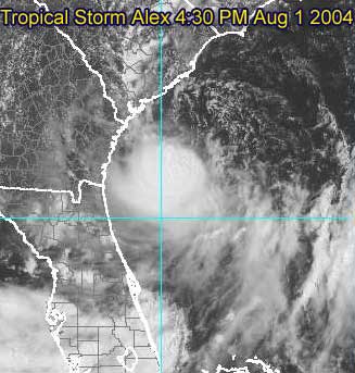
Afternoon visible of Alex with broad center partially exposed
The National Hurricane Center track carries Alex north and northeastward just off the coast of South Carolina, over Cape Fear and Carteret County, North Carolina, and then very close to Cape Hatteras.
Any minor deviation from this path could either result in the storm never making landfall, or a track over the coastal counties of the Carolinas. Specifically, deviation to the left would result in tropical storm conditions outside of the current warning area, so people in the watch area and perhaps as far down the coast as Savannah should keep this in mind.
Alex information:
Event Related Links
Charleston, SC Long Range Radar
Jacksonville, FL Long Range Radar
Various forecast tracks from earlier model runs, Wunderground.com
General Links
Current Aircraft Recon Info
NRL Monterey Marine Meteorology Division Forecast Track of Active Systems (Good Forecast Track Graphic and Satellite Photos)
Check the Storm Forum from time to time for comments on any new developing system.
Follow worldwide SST evolution here:
Global SST Animation
NASA GHCC Interactive Satellite images at:
North Atlantic Visible (Daytime Only), Infrared, Water Vapor
Some forecast models:
NGM, AVN, MRF, ETA ECMWF
AVN, CMC, GFDL, JMA, NOGAPS, UKMET
DoD Weather Models (NOGAPS, AVN, MRF)
Multi-model plots from WREL
Other commentary at Mike Anderson's East Coast Tropical Weather Center, Independentwx.com, Robert Lightbown/Crown Weather Tropical Update Accuweather's Joe Bastardi (now subcriber only unfortunately), Hurricane Alley North Atlantic Page, Cyclomax (Rich B.), Hurricane City , mpittweather , Gary Gray's Millennium Weather, Barometer Bob's Hurricane Hollow, Snonut,
Even more on the links page.
HF 1956z01august
Edited by HanKFranK (Sun Aug 01 2004 04:59 PM)
|
|



 Previous
 Index
Index
 Next
Next
 Flat
Flat
 Edit
Edit
 Reply
Reply
 Quote
Quote


