F
Current Radar or Satellite Image

Flhurricane.com - Central Florida Hurricane Center - Tracking Storms since 1995Hurricanes Without the Hype! Since 1995


First day of the Atlantic Hurricane season, no tropical activity on the horizon in the near term. Mid August is usually when things pick up.
Days since last H. Landfall - US: Any 277 (Idalia) , Major: 277 (Idalia) Florida - Any: 277 (Idalia) Major: 277 (Idalia)


News Talkback >> 2004 News Talkbacks

HanKFranK
User


Reged:
Posts: 1841
Loc: Graniteville, SC
Alex menacing the coastal southeast
      Sun Aug 01 2004 07:56 PM

Alex is slowly getting more organized. The center is still fairly broad and mesoscale vortexes (short-lived mini-centers) can be seen whipping around the periphery of the sheared CDO feature east of the Georgia coastline. Alex is currently hanging out on a limb of the atlantic ridge, a narrow height axis is oriented Sw-Ne to the west and north of the system. Some outflow aloft is apparent with Alex as well, and it is making a bulge on the ridge keeping the storm stuck off Georgia today.

When the storm begins to move it will cross under and possibly travel along this narrow ridge and find favorable conditions for strengthening. The SHIPS intensity model is calling for more strengthening than the official forecast.

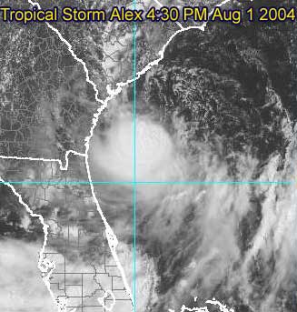
Afternoon visible of Alex with broad center partially exposed

The National Hurricane Center track carries Alex north and northeastward just off the coast of South Carolina, over Cape Fear and Carteret County, North Carolina, and then very close to Cape Hatteras.
Any minor deviation from this path could either result in the storm never making landfall, or a track over the coastal counties of the Carolinas. Specifically, deviation to the left would result in tropical storm conditions outside of the current warning area, so people in the watch area and perhaps as far down the coast as Savannah should keep this in mind.

Alex information:

Event Related Links
Charleston, SC Long Range Radar
Jacksonville, FL Long Range Radar

Various forecast tracks from earlier model runs, Wunderground.com

General Links
Current Aircraft Recon Info

NRL Monterey Marine Meteorology Division Forecast Track of Active Systems (Good Forecast Track Graphic and Satellite Photos)

Check the Storm Forum from time to time for comments on any new developing system.

Follow worldwide SST evolution here:

Global SST Animation

NASA GHCC Interactive Satellite images at:

North Atlantic Visible (Daytime Only), Infrared, Water Vapor

Some forecast models:
NGM, AVN, MRF, ETA ECMWF
AVN, CMC, GFDL, JMA, NOGAPS, UKMET

DoD Weather Models (NOGAPS, AVN, MRF)

Multi-model plots from WREL

Other commentary at Mike Anderson's East Coast Tropical Weather Center, Independentwx.com, Robert Lightbown/Crown Weather Tropical Update Accuweather's Joe Bastardi (now subcriber only unfortunately), Hurricane Alley North Atlantic Page, Cyclomax (Rich B.), Hurricane City , mpittweather , Gary Gray's Millennium Weather, Barometer Bob's Hurricane Hollow, Snonut,
Even more on the links page.
HF 1956z01august

Edited by HanKFranK (Sun Aug 01 2004 08:59 PM)

Post Extras Print Post   Remind Me!     Notify Moderator


Entire topic
Subject Posted by Posted on
* Alex menacing the coastal southeast HanKFranK Sun Aug 01 2004 07:56 PM
. * * Re: Alex menacing the coastal southeast cyclone_head   Mon Aug 02 2004 01:25 PM
. * * Re: Alex menacing the coastal southeast LI Phil   Sun Aug 01 2004 08:01 PM
. * * Re: Alex menacing the coastal southeast HanKFranK   Sun Aug 01 2004 08:10 PM
. * * Re: Alex menacing the coastal southeast Carl   Sun Aug 01 2004 08:26 PM
. * * Re: Alex menacing the coastal southeast James88   Sun Aug 01 2004 08:42 PM
. * * Multiple Centers Robert   Sun Aug 01 2004 08:48 PM
. * * Re: Multiple Centers Robert   Sun Aug 01 2004 08:59 PM
. * * Re: Multiple Centers HanKFranK   Sun Aug 01 2004 10:04 PM
. * * if only.. HanKFranK   Sun Aug 01 2004 10:15 PM
. * * Uncalled for activity LI Phil   Sun Aug 01 2004 10:11 PM
. * * Circular Storm James88   Sun Aug 01 2004 10:15 PM
. * * Alex LoisCane   Sun Aug 01 2004 10:30 PM
. * * Re: Alex Tropics Guy   Sun Aug 01 2004 11:37 PM
. * * Alex.... Anonymous   Mon Aug 02 2004 12:01 AM
. * * Alex....South? Anonymous   Mon Aug 02 2004 12:09 AM
. * * recon Anonymous   Mon Aug 02 2004 12:15 AM
. * * Re: recon Anonymous   Mon Aug 02 2004 01:41 AM
. * * alex LoisCane   Mon Aug 02 2004 02:43 AM
. * * Re: recon danielwAdministrator   Mon Aug 02 2004 02:03 AM
. * * Re: recon Anonymous   Mon Aug 02 2004 01:57 PM
. * * Re: recon BillD   Mon Aug 02 2004 02:11 PM
. * * triplets bobbi   Mon Aug 02 2004 04:34 PM
. * * 11 pm hurricane_run   Mon Aug 02 2004 02:38 AM
. * * Re: 11 pm hurricane_run   Mon Aug 02 2004 02:39 AM
. * * Re: 11 pm hurricane_run   Mon Aug 02 2004 03:01 AM
. * * Re: 11 pm Old Sailor   Mon Aug 02 2004 02:48 AM
. * * 91L and friend, plus Alex joepub1   Mon Aug 02 2004 03:16 AM
. * * Re: 91L and friend, plus Alex HanKFranK   Mon Aug 02 2004 03:49 AM
. * * Re: 91L and friend, plus Alex Cycloneye   Mon Aug 02 2004 04:04 AM
. * * Re: 91L and friend, plus Alex danielwAdministrator   Mon Aug 02 2004 04:17 AM
. * * Re: 91L and friend, plus Alex danielwAdministrator   Mon Aug 02 2004 05:42 AM
. * * Re: Radar Data Ed DunhamAdministrator   Mon Aug 02 2004 04:48 AM
. * * Re: Radar Data danielwAdministrator   Mon Aug 02 2004 05:03 AM
. * * Re: Radar Data Joe   Mon Aug 02 2004 05:49 AM
. * * Re: New Vortex report danielwAdministrator   Mon Aug 02 2004 05:56 AM
. * * Re: New Vortex report James88   Mon Aug 02 2004 06:57 AM
. * * Re:07Z Update danielwAdministrator   Mon Aug 02 2004 07:22 AM
. * * Still 35 knots James88   Mon Aug 02 2004 08:42 AM
. * * Re: Still 35 knots danielwAdministrator   Mon Aug 02 2004 09:05 AM
. * * Re: 91L danielwAdministrator   Mon Aug 02 2004 09:30 AM
. * * Re: 91L James88   Mon Aug 02 2004 09:36 AM
. * * Re: 91L danielwAdministrator   Mon Aug 02 2004 09:52 AM
. * * Re: 91L Visible Sat danielwAdministrator   Mon Aug 02 2004 10:11 AM
. * * Re: 91L Visible Sat James88   Mon Aug 02 2004 10:33 AM
. * * Re: Recon danielwAdministrator   Mon Aug 02 2004 10:40 AM
. * * Re: Recon javlin   Mon Aug 02 2004 12:14 PM
. * * Re: Recon James88   Mon Aug 02 2004 12:22 PM
. * * Re: Recon James88   Mon Aug 02 2004 12:12 PM
. * * Re: 91L danielwAdministrator   Mon Aug 02 2004 09:41 AM
. * * Re: 91L danielwAdministrator   Mon Aug 02 2004 09:36 AM
. * * Re: Still 35 knots Rich B   Mon Aug 02 2004 08:58 AM
. * * out east hurricane_run   Mon Aug 02 2004 02:54 AM
. * * Re: out east Old Sailor   Mon Aug 02 2004 03:14 AM
. * * Re: out east hurricane_run   Mon Aug 02 2004 02:56 AM
. * * Re: looking east...... Tropics Guy   Mon Aug 02 2004 03:04 AM
. * * Re: out east Jamiewx   Mon Aug 02 2004 03:00 AM
. * * Re: out east danielwAdministrator   Mon Aug 02 2004 03:04 AM
. * * Re: out east hurricane_run   Mon Aug 02 2004 03:02 AM
. * * Whoa there... LI Phil   Mon Aug 02 2004 12:34 AM
. * * Re: Whoa there... Storm Cooper   Mon Aug 02 2004 01:14 AM
. * * Re: Whoa there... danielwAdministrator   Mon Aug 02 2004 12:43 AM
. * * GOM hints of a possible mid/upper level circulation Frank P   Sun Aug 01 2004 11:00 PM
. * * Could Alex make hurricane? Anonymous   Sun Aug 01 2004 11:32 PM
. * * Re: GOM hints of a possible mid/upper level circulation teal61   Sun Aug 01 2004 11:24 PM
. * * Re: GOM hints of a possible mid/upper level circulation Frank P   Sun Aug 01 2004 11:52 PM
. * * Re: GOM hints of a possible mid/upper level circulation danielwAdministrator   Mon Aug 02 2004 12:12 AM
. * * Re: GOM hints of a possible mid/upper level circulation danielwAdministrator   Sun Aug 01 2004 11:51 PM
. * * Re: GOM hints of a possible mid/upper level circulation Frank P   Mon Aug 02 2004 12:01 AM
. * * Re: Multiple Centers Rich B   Sun Aug 01 2004 09:31 PM
. * * Re: Multiple Centers James88   Sun Aug 01 2004 09:34 PM
. * * Ain't Misbehavin' LI Phil   Sun Aug 01 2004 09:43 PM
. * * Re: Ain't Misbehavin' James88   Sun Aug 01 2004 10:03 PM

Extra information
0 registered and 550 anonymous users are browsing this forum.

Moderator:  


Forum Permissions
      You cannot start new topics
      You cannot reply to topics
      HTML is disabled
      UBBCode is enabled

Rating: *****
Thread views: 13731

Rate this thread

Jump to

Note: This is NOT an official page. It is run by weather hobbyists and should not be used as a replacement for official sources. 
CFHC's main servers are currently located at Hostdime.com in Orlando, FL.
Image Server Network thanks to Mike Potts and Amazon Web Services. If you have static file hosting space that allows dns aliasing contact us to help out! Some Maps Provided by:
Great thanks to all who donated and everyone who uses the site as well. Site designed for 800x600+ resolution
When in doubt, take the word of the National Hurricane Center