CFHC

Reged:
Posts: 161
Loc: East Central Florida
|
 Cristobal... See the East? Take a Hike
Wed Aug 07 2002 09:23 AM
|
|
|
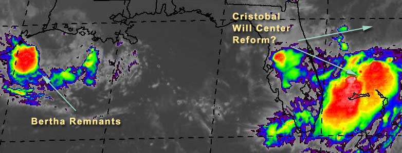
Tropical Storm Cristobal is being naughty. The models are telling it to go east, but instead it moves south.
What's really going on is the trough/front going through Georgia was supposed to kick it eastward, but instead it creeped south. The "center" is northeast of where you see all the rain and clouds. Which brings up the possibility where the center just may reform closer to Florida and miss the eastward jog altogether, leaving it to taunt us and the Bahamas for days on end. The upper level conditions aren't that great for strengthening now, but if it hangs around it could build up, just a stones throw away from us.
The rain in Central Florida was caused by the front coming down and enhanced by Cristobal, so we've already seen some of it here. It's important to watch Cristobal until it has decided to move east away from us.
Bertha Remnants are in the Gulf now, but rather disorganized. It won't have much time to reform--so other than a lot of rain, I don't see much from it.
Ed Dunham is making posts in our Storm Forum with some updates, and Snonut is back making some sporadic updates as well.
Dr William Gray and Company have put up the august updates of storm activity and have dropped it to 9 named stormss, 4 hurricanes, and 1 intense hurricane. I suspect this may be a tad too conservative, but not far off the mark.
NASA GHCC Interactive Satellite images at:
North Atlantic Visible (Daytime Only), Infrared, Water Vapor
Some forecast models:
NGM, AVN, MRF, ETA ECMWF
DoD Weather Models (NOGAPS, AVN, MRF)
AVN, ECMWF, GFDL, MM5, NOGAPS, UKMET
Other commentary at Mike Anderson's East Coast Triopical Weather Center, Accuweather's Joe Bastardi, Hurricane City, Gary Gray's Millennium Weather, Barometer Bob's Hurricane Hollow, Snonut, Ed Dunham in our Storm Forum Even more on the links page.
- [mike@flhurricane.com]
|
|


 Flat
Flat


